Home > North America > Saint Kitts and Nevis > Maps
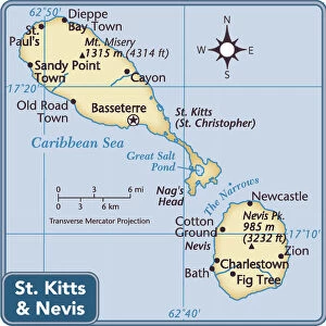
Map of Saint Kitts, 19th Century

![]()
Wall Art and Photo Gifts from Fine Art Storehouse
Map of Saint Kitts, 19th Century
Vintage engraving of a Map of Saint Kitts, 19th Century. Saint Kitts and Nevis, also known as the Federation of Saint Christopher and Nevis, [4] is an island country in the West Indies. Located in the Leeward Islands chain of the Lesser Antilles
Unleash your creativity and transform your space into a visual masterpiece!
duncan1890
Media ID 14756364
© This content is subject to copyright
1870s Antilles Caribbean Equipment Lesser Antilles Navigational Equipment Retro Saint Kitts And Nevis Styles Supplies The Americas Victorian West Indies Saint Kitts
FEATURES IN THESE COLLECTIONS
> Fine Art Storehouse
> Map
> Historical Maps
> Maps and Charts
> Early Maps
> North America
> Saint Kitts and Nevis
> Maps
EDITORS COMMENTS
This vintage engraving of a 19th-century map of Saint Kitts takes us on a journey back in time to the captivating Caribbean island. The print showcases the intricate details of this historical cartographic masterpiece, transporting us to an era when navigational equipment was essential for exploration. Saint Kitts and Nevis, also known as the Federation of Saint Christopher and Nevis, is beautifully depicted within the Leeward Islands chain of the Lesser Antilles. This old-fashioned woodcut print captures the essence of Victorian-era illustration and painting styles, evoking a sense of nostalgia for times gone by. As we admire this antique map, we can almost feel ourselves stepping into history. The delicate lines and meticulous craftsmanship remind us that maps were once invaluable tools for discovering new lands and charting unknown territories. With its rich history and stunning natural beauty, Saint Kitts continues to captivate travelers from around the world. This print serves as a reminder that even in our modern age with advanced technology at our fingertips, there is still something enchanting about exploring old maps like this one – they offer glimpses into forgotten worlds and inspire curiosity about what lies beyond familiar shores. Whether you're an avid collector or simply appreciate art that tells stories from days long past, this vintage engraving will transport you to another time as you immerse yourself in its intricate details.
MADE IN AUSTRALIA
Safe Shipping with 30 Day Money Back Guarantee
FREE PERSONALISATION*
We are proud to offer a range of customisation features including Personalised Captions, Color Filters and Picture Zoom Tools
SECURE PAYMENTS
We happily accept a wide range of payment options so you can pay for the things you need in the way that is most convenient for you
* Options may vary by product and licensing agreement. Zoomed Pictures can be adjusted in the Cart.