Home > North America > Guatemala > Maps
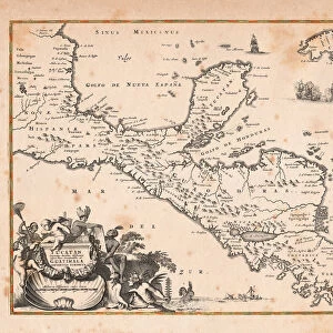
Mexico and Central America map 1867

![]()
Wall Art and Photo Gifts from Fine Art Storehouse
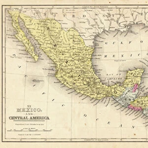
Mexico and Central America map 1867
Mitchellas Modern Atlas - Published by E.H. Butler and Co - Philadelphia 1867
Unleash your creativity and transform your space into a visual masterpiece!
THEPALMER
Media ID 13609201
© This content is subject to copyright
Central America Guatemala Honduras Mexico
FEATURES IN THESE COLLECTIONS
> Fine Art Storehouse
> Map
> Historical Maps
> Fine Art Storehouse
> Map
> USA Maps
> Maps and Charts
> Early Maps
> North America
> Guatemala
> Maps
> North America
> Honduras
> Maps
> North America
> Mexico
> Maps
> North America
> United States of America
> Maps
EDITORS COMMENTS
This print showcases a remarkable piece of history - the Mexico and Central America map from 1867. Published by E. H. Butler and Co in Philadelphia, this exquisite artifact takes us back to a time when cartography was an art form in itself. The intricate details etched into this old lithograph are truly awe-inspiring. As we gaze upon this vintage masterpiece, our eyes are drawn to the rich tapestry of geographical features that define these lands. From the rugged mountains of Guatemala to the vast plains of Honduras, every contour is meticulously depicted with precision and skill. This map serves as a testament to the dedication and expertise of those who crafted it. The sepia tones lend an air of nostalgia, transporting us back to an era where exploration was at its peak. It reminds us of a time when adventurers embarked on perilous journeys through uncharted territories, armed only with their maps and unwavering determination. Beyond its historical significance, this artwork also holds aesthetic appeal. The delicate engravings create a visual symphony that captivates our imagination. Its horizontal format allows for easy appreciation of each detail without overwhelming the viewer. "The Mexico and Central America Map 1867" by THEPALMER is not just a mere depiction; it is an invitation to explore forgotten realms and uncover hidden treasures within these ancient lands. Whether you're an avid collector or simply appreciate fine art, this antique lithograph will undoubtedly be cherished for generations to come.
MADE IN AUSTRALIA
Safe Shipping with 30 Day Money Back Guarantee
FREE PERSONALISATION*
We are proud to offer a range of customisation features including Personalised Captions, Color Filters and Picture Zoom Tools
SECURE PAYMENTS
We happily accept a wide range of payment options so you can pay for the things you need in the way that is most convenient for you
* Options may vary by product and licensing agreement. Zoomed Pictures can be adjusted in the Cart.