Home > Maps and Charts > Africa
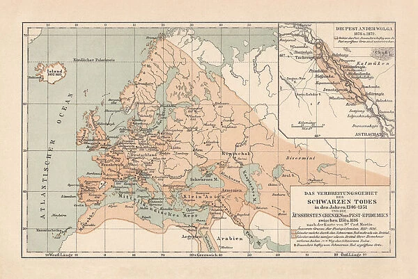
Pestilence in Europe, mid-14th century, lithograph, published in 1880
![]()

Wall Art and Photo Gifts from Fine Art Storehouse
Pestilence in Europe, mid-14th century, lithograph, published in 1880
Ancient map of the area of pestilence in Europe, Western Asia, and North Africa in the years 1346 - 1351. Lithograph, published in 1880
Unleash your creativity and transform your space into a visual masterpiece!
Media ID 13666837
© ZU_09
91555 Circa 14th Century Coastal Feature Contour Drawing Dead Death Epidemic Ethnocultural History European Culture Illness Island Medical Condition Medieval Mediterranean Countries Mediterranean Sea Middle Ages Topographic Map Topography Unpleasant Smell Mediterran Ulcer
FEATURES IN THESE COLLECTIONS
> Africa
> Related Images
> Asia
> Related Images
> Europe
> Related Images
> Fine Art Storehouse
> Map
> Historical Maps
> Maps and Charts
> Early Maps
EDITORS COMMENTS
This lithograph, published in 1880, transports us back to the mid-14th century when Europe was ravaged by a devastating pestilence. The ancient map depicted here offers a glimpse into the medical condition and cartography of that time, showcasing the areas affected by this horrific epidemic. From Western Asia to North Africa, this topographic map reveals the extent of its reach. The image itself is an engraved masterpiece, capturing the essence of European culture during the Middle Ages. Its horizontal layout allows for a comprehensive view of coastal features along the Mediterranean Sea - an important trade route connecting various civilizations. As we delve into history through this antique print, we are reminded of the grim reality faced by our ancestors. Death lurked around every corner as illness spread like wildfire across continents. The contour drawing emphasizes both the geographical landscape and ethnocultural history intertwined within these regions. Although devoid of people in this particular rendition, one can almost imagine how bustling cities and once-thriving communities succumbed to despair during those dark times. The unpleasant smell and ulcerous wounds associated with this pestilence haunt our imagination as we contemplate its impact on society. Intriguingly preserved through photography in 2015, this lithograph serves as a poignant reminder of human vulnerability throughout history – reminding us to appreciate our present while acknowledging the lessons learned from our past encounters with death and disease.
MADE IN AUSTRALIA
Safe Shipping with 30 Day Money Back Guarantee
FREE PERSONALISATION*
We are proud to offer a range of customisation features including Personalised Captions, Color Filters and Picture Zoom Tools
SECURE PAYMENTS
We happily accept a wide range of payment options so you can pay for the things you need in the way that is most convenient for you
* Options may vary by product and licensing agreement. Zoomed Pictures can be adjusted in the Cart.


