Home > Animals > Birds > Gruiformes > Rallidae > Chestnut Rail
MA Hampshire Hatfield Vector Road Map

![]()
Wall Art and Photo Gifts from Fine Art Storehouse
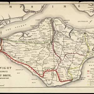
MA Hampshire Hatfield Vector Road Map
MA Hampshire Hatfield Vector Road Map. All source data is in the public domain. U.S. Census Bureau Census Tiger. Used Layers: areawater, linearwater, roads, rails, cousub, pointlm, uac10
Unleash your creativity and transform your space into a visual masterpiece!
Frank Ramspott
Media ID 20690841
© Frank Ramspott, all rights reserved
City Map Computer Graphic County Digital Composite District Geographical Border Hampshire Hatfield Massachusetts Road Map Text Vector Bradstreet Digitally Generated Image Hadley Westbrook
FEATURES IN THESE COLLECTIONS
> Animals
> Birds
> Gruiformes
> Rallidae
> Chestnut Rail
> Animals
> Birds
> Gruiformes
> Rallidae
> Water Rail
> Animals
> Mammals
> Cats (Wild)
> Tiger
> Arts
> Landscape paintings
> Waterfall and river artworks
> River artworks
> Arts
> Portraits
> Pop art gallery
> Street art portraits
> Arts
> Street art graffiti
> Digital art
> Digital paintings
> Europe
> United Kingdom
> England
> Hampshire
> Related Images
> Fine Art Storehouse
> Map
> Reference Maps
> Maps and Charts
> Related Images
EDITORS COMMENTS
This print showcases the MA Hampshire Hatfield Vector Road Map, a stunning piece of cartography art created by Frank Ramspott. The intricate design and attention to detail in this digitally generated image are truly remarkable. The map encompasses various layers of information sourced from the public domain, including data from the U. S. Census Bureau Census Tiger. It incorporates elements such as roads, rails, water bodies like rivers and lakes, as well as important landmarks like cities and towns within Hampshire County. The vibrant colors used in this vector map bring it to life, making it an eye-catching addition to any space. Its clean lines and precise typography make it easy to navigate through the geographical borders depicted on the map. While there are no people featured in this image, its focus on physical geography allows viewers to appreciate the natural beauty of places like Laurel Park, Westbrook, Bradstreet, Chestnut Mountain, Hog Mountain, Hadley, Russelville and more. Whether you're a fan of maps or simply appreciate visually appealing artwork that combines both form and function seamlessly together - this digital composite is sure to captivate your imagination. It's perfect for anyone who appreciates fine art with a touch of geographic exploration!
MADE IN AUSTRALIA
Safe Shipping with 30 Day Money Back Guarantee
FREE PERSONALISATION*
We are proud to offer a range of customisation features including Personalised Captions, Color Filters and Picture Zoom Tools
SECURE PAYMENTS
We happily accept a wide range of payment options so you can pay for the things you need in the way that is most convenient for you
* Options may vary by product and licensing agreement. Zoomed Pictures can be adjusted in the Cart.