Home > North America > United States of America > Arizona > Gilbert
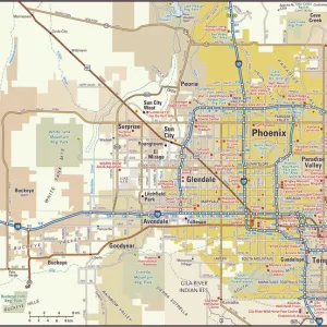
Gilbert Arizona US City Street Map

![]()
Wall Art and Photo Gifts from Fine Art Storehouse
Gilbert Arizona US City Street Map
Vector Illustration of a City Street Map of Gilbert, Arizona, USA. Scale 1:60, 000.
All source data is in the public domain.
U.S. Geological Survey, US Topo
Used Layers:
USGS The National Map: National Hydrography Dataset (NHD)
USGS The National Map: National Transportation Dataset (NTD)
Unleash your creativity and transform your space into a visual masterpiece!
Frank Ramspott
Media ID 15055185
© Frank Ramspott, all rights reserved
Aerial View Arizona Computer Graphic Directly Above Gray Green Road Map Street Map Text Digitally Generated Image Gilbert
FEATURES IN THESE COLLECTIONS
> Aerial Photography
> Related Images
> Animals
> Insects
> Hemiptera
> Green Scale
> Arts
> Landscape paintings
> Waterfall and river artworks
> River artworks
> Arts
> Portraits
> Pop art gallery
> Street art portraits
> Fine Art Storehouse
> Map
> Street Maps
> Fine Art Storehouse
> Map
> USA Maps
> Maps and Charts
> Geological Map
> North America
> United States of America
> Arizona
> Gilbert
> North America
> United States of America
> Lakes
> Related Images
> North America
> United States of America
> Maps
EDITORS COMMENTS
This print showcases a meticulously detailed city street map of Gilbert, Arizona, USA. With a scale of 1:60,000, every intricate feature is beautifully illustrated in this vector image. The artist has utilized various layers from the public domain data sources such as USGS The National Map: National Hydrography Dataset (NHD) and USGS The National Map: National Transportation Dataset (NTD), ensuring accuracy and authenticity. The stunning aerial view captures the essence of Gilbert's physical geography with its meandering river, serene lake, and bustling streets lined with buildings. The digitally generated image presents a colorful composition where shades of gray, green, blue, and white harmoniously blend together. This artwork by Frank Ramspott is not just a mere map; it is an exquisite piece of cartography design that seamlessly combines artistry with functionality. It allows viewers to explore the city's roads and navigate through its vibrant neighborhoods without even stepping foot on them. With no people present in the image, all attention is drawn towards the remarkable craftsmanship behind this visually appealing creation. Whether you are an avid traveler or simply appreciate fine art prints that showcase urban landscapes at their finest, this Gilbert City Street Map will undoubtedly captivate your imagination.
MADE IN AUSTRALIA
Safe Shipping with 30 Day Money Back Guarantee
FREE PERSONALISATION*
We are proud to offer a range of customisation features including Personalised Captions, Color Filters and Picture Zoom Tools
SECURE PAYMENTS
We happily accept a wide range of payment options so you can pay for the things you need in the way that is most convenient for you
* Options may vary by product and licensing agreement. Zoomed Pictures can be adjusted in the Cart.