Home > Animals > Insects > Hemiptera > Green Scale
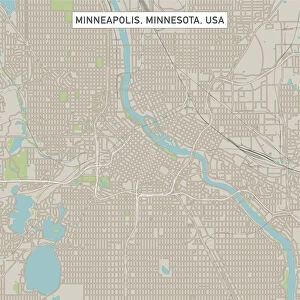
Saint Paul Minnesota US City Street Map

![]()
Wall Art and Photo Gifts from Fine Art Storehouse
Saint Paul Minnesota US City Street Map
Vector Illustration of a City Street Map of Saint Paul, Minnesota, USA. Scale 1:60, 000.
All source data is in the public domain.
U.S. Geological Survey, US Topo
Used Layers:
USGS The National Map: National Hydrography Dataset (NHD)
USGS The National Map: National Transportation Dataset (NTD)
Unleash your creativity and transform your space into a visual masterpiece!
Frank Ramspott
Media ID 15215822
© Frank Ramspott, all rights reserved
Aerial View City Map Computer Graphic Directly Above Downtown District Gray Minnesota Mississippi River Road Map Text Digitally Generated Image Green Color Saint Paul White Color
FEATURES IN THESE COLLECTIONS
> Aerial Photography
> Related Images
> Animals
> Insects
> Hemiptera
> Green Scale
> Arts
> Landscape paintings
> Waterfall and river artworks
> River artworks
> Arts
> Portraits
> Pop art gallery
> Street art portraits
> Fine Art Storehouse
> Map
> Street Maps
> Fine Art Storehouse
> Map
> USA Maps
> Maps and Charts
> Geological Map
> North America
> United States of America
> Lakes
> Related Images
> North America
> United States of America
> Maps
> North America
> United States of America
> Minnesota
> Related Images
> North America
> United States of America
> Mississippi
> Related Images
EDITORS COMMENTS
This print showcases a meticulously detailed vector illustration of the vibrant city street map of Saint Paul, Minnesota, USA. With a scale of 1:60,000, every intricate aspect of this bustling city is beautifully depicted. The source data used for this artwork is in the public domain and comes from reputable sources such as the U. S. Geological Survey and US Topo. The various layers utilized in creating this masterpiece include the USGS National Hydrography Dataset (NHD) and National Transportation Dataset (NTD), ensuring accuracy and precision in representing water bodies, transportation networks, roads, and streets within Saint Paul. From its iconic Mississippi River meandering through the heart of the city to its charming downtown district surrounded by picturesque lakes and rivers, this visually stunning image captures all that makes Saint Paul unique. The digitally generated design presents an aerial view directly above the cityscape with text elements elegantly integrated into shades of gray, blue, white color scheme complemented by touches of refreshing green. Perfectly suited for any space or occasion where appreciation for cartography meets artistry; this print offers a glimpse into Saint Paul's physical geography while omitting human presence intentionally. Created by talented artist Frank Ramspott exclusively for Fine Art Storehouse – it is an exquisite addition to any collection without commercial use intentions mentioned.
MADE IN AUSTRALIA
Safe Shipping with 30 Day Money Back Guarantee
FREE PERSONALISATION*
We are proud to offer a range of customisation features including Personalised Captions, Color Filters and Picture Zoom Tools
SECURE PAYMENTS
We happily accept a wide range of payment options so you can pay for the things you need in the way that is most convenient for you
* Options may vary by product and licensing agreement. Zoomed Pictures can be adjusted in the Cart.