Fraud Blocker Skip to main content

Framed Print > Asia > Singapore > Maps

Maps Framed Print Collection

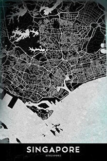
Discover the vibrant and diverse landscapes of Singapore with our Maps of Singapore collection from Media Storehouse. These beautifully crafted framed prints showcase the city-state's iconic landmarks, from the bustling streets of Chinatown and Little India to the tranquil Gardens by the Bay and the majestic Marina Bay Sands. Each map is meticulously designed to capture the essence of Singapore's rich cultural heritage and modern urban development. Bring a piece of this fascinating destination into your home or office and let the beauty of Singapore inspire you every day.

Maps of Singapore Asia are a collection that depict the geography and history of the island nation

Choose a picture from our collection for your Wall Art and Photo Gifts

49 Framed Prints

Background imageMaps Framed Print Collection: Map of Singapore 1898

Map of Singapore 1898 Original edition from my own archives Source : Brockhaus 1898

Background imageMaps Framed Print Collection: Singapore, bastion in the East, by G. H. Davis

Singapore, bastion in the East, by G. H. Davis
Britains great bastion in the East: Singapore, stubborn obstacle to Japans ambitious projects in Southern Asia during the Second World War

Background imageMaps Framed Print Collection: 1 Maps 51

1 Maps 51
Emiliano Deificus

Background imageMaps Framed Print Collection: Black Maps Earth Tones 81

Black Maps Earth Tones 81
Emiliano Deificus

Background imageMaps Framed Print Collection: Singapore

Singapore
Antique illustration of a Republic of Singapore

Background imageMaps Framed Print Collection: Telegraph map of the Eastern World, 1865. Creator: John Dower

Telegraph map of the Eastern World, 1865. Creator: John Dower
Telegraph map of the Eastern World, 1865. Map showing '...the progress of telegraphic communication from England in the directions of India, China

Background imageMaps Framed Print Collection: Map of the Malay Peninsula, c.1900 (engraving)

Map of the Malay Peninsula, c.1900 (engraving)
533325 Map of the Malay Peninsula, c.1900 (engraving); (add.info.: Map showing historical boundaries of the Malay Peninsula, Sumatra, and Singapore, circa 1902)

Background imageMaps Framed Print Collection: A plan of the harbour near Singapore by Captain D.l. Ross, FRS Marine Surveyor General

A plan of the harbour near Singapore by Captain D.l. Ross, FRS Marine Surveyor General, 1827 (Pencil)
7339515 A plan of the harbour near Singapore by Captain D.l. Ross, FRS Marine Surveyor General, 1827 (Pencil, black ink and grey wash) by Ross, D. I

Background imageMaps Framed Print Collection: China Sea Singapore Main Strait From Tree I (pulo Angup) to Battam Bay Surveyed by Staff Commander

China Sea Singapore Main Strait From Tree I (pulo Angup) to Battam Bay Surveyed by Staff Commander J.W. Reed, R.N
7339589 China Sea Singapore Main Strait From Tree I (pulo Angup) to Battam Bay Surveyed by Staff Commander J.W. Reed, R.N. and the officers of H.M.S

Background imageMaps Framed Print Collection: World map. Believed by some to have been compiled by Zheng He.Zheng He (1371-1435)or Cheng Ho

World map. Believed by some to have been compiled by Zheng He.Zheng He (1371-1435)or Cheng Ho
529404 World map. Believed by some to have been compiled by Zheng He.Zheng He (1371-1435)or Cheng Ho, China's most famous navigator

Background imageMaps Framed Print Collection: City Love Maps 81

City Love Maps 81
Emiliano Deificus

Background imageMaps Framed Print Collection: City Heart Maps 81

City Heart Maps 81
Emiliano Deificus

Background imageMaps Framed Print Collection: Black Maps 81

Black Maps 81
Emiliano Deificus

Background imageMaps Framed Print Collection: Map of British Malaya and Singapore, 1890s

Map of British Malaya and Singapore, 1890s
Vintage engraving of Map of British Malaya and Singapore, 1890s, 19th Century

Background imageMaps Framed Print Collection: 1855 Colton Map Of The East Indies Singapore

1855 Colton Map Of The East Indies Singapore
1855, Colton Map of the East Indies, Singapore, Thailand, Borneo, Malaysia

Background imageMaps Framed Print Collection: 1852 Bellin Map Of Sumatra Malaca And Singapore

1852 Bellin Map Of Sumatra Malaca And Singapore
1852, Bellin Map of Sumatra, Malaca, and Singapore

Background imageMaps Framed Print Collection: 1818 Pinkerton Map Of The East Indies And Southeast Asia

1818 Pinkerton Map Of The East Indies And Southeast Asia
1818, Pinkerton Map of the East Indies and Southeast Asia, Singapore, Borneo, Java, Sumatra, Thailand, John Pinkerton, 1758 - 1826, Scottish antiquarian, cartographer, UK

Background imageMaps Framed Print Collection: 1810 Tardieu Map Of The East Indies Singapore

1810 Tardieu Map Of The East Indies Singapore
1810, Tardieu Map of the East Indies, Singapore, Southeast Asia, Sumatra, Borneo, Java

Background imageMaps Framed Print Collection: 1801 Cary Map Of The East Indies And Southeast Asia

1801 Cary Map Of The East Indies And Southeast Asia
1801, Cary Map of the East Indies and Southeast Asia, Singapore, Borneo, Sumatra, Java, Philippines, John Cary, 1754 - 1835, English cartographer

Background imageMaps Framed Print Collection: 1780 Raynal And Bonne Map Of The East Indies

1780 Raynal And Bonne Map Of The East Indies
1780, Raynal and Bonne Map of the East Indies, Singapore, Java, Sumatra, Borneo, Rigobert Bonne 1727 - 1794, one of the most important cartographers of the late 18th century

Background imageMaps Framed Print Collection: 1770 Bonne Map Of The East Indies Java Sumatra

1770 Bonne Map Of The East Indies Java Sumatra
1770, Bonne Map of the East Indies, Java, Sumatra, Borneo, Singapore, Rigobert Bonne 1727 - 1794, one of the most important cartographers of the late 18th century

Background imageMaps Framed Print Collection: 1770 Bonne Map Of India Southeast Asia And The East Indies

1770 Bonne Map Of India Southeast Asia And The East Indies
1770, Bonne Map of India, Southeast Asia and The East Indies, Thailand, Borneo, Singapore, Rigobert Bonne 1727 - 1794, one of the most important cartographers of the late 18th century

Background imageMaps Framed Print Collection: 1710 Ottens Map Of Southeast Asia Singapore Thailand

1710 Ottens Map Of Southeast Asia Singapore Thailand
1710, Ottens Map of Southeast Asia, Singapore, Thailand, Siam, Malaysia, Sumatra, Borneo

Background imageMaps Framed Print Collection: EDITORIAL Map showing details of the fall of Singapore, 15 February, 1942

EDITORIAL Map showing details of the fall of Singapore, 15 February, 1942. From The War in Pictures Third Year
15 February, 1942, 20th Century, Archival, Archive, Asia, Conflict, Details, Engraving, fall of Singapore, Historical, History, Illustration, Island, Old, Period, Picture, Print, Second World War

Background imageMaps Framed Print Collection: EDITORIAL Retreat to Singapore. Map showing the stages of the Japanese advance

EDITORIAL Retreat to Singapore. Map showing the stages of the Japanese advance
1942, 20th Century, 30-31 January, Advance, Archival, Archive, Asia, Conflict, Country, Engraving, Geographical, Geography, Historical, History, Illustration, in relation to, Insets, Japanese

Background imageMaps Framed Print Collection: Singapore

Singapore
StudioSix

Background imageMaps Framed Print Collection: Medway ME7 5 Map

Medway ME7 5 Map
Postcode Sector Map of Medway ME7 5

Background imageMaps Framed Print Collection: North Somerset BS23 4 Map

North Somerset BS23 4 Map
Postcode Sector Map of North Somerset BS23 4

Background imageMaps Framed Print Collection: Historical city map of Singapore and Singapore Strait, published 1897

Historical city map of Singapore and Singapore Strait, published 1897
Historical city map of Singapore and Singapore Strait. Wood engraving, published in 1897

Background imageMaps Framed Print Collection: SINGAPORE

SINGAPORE
StudioSix

Background imageMaps Framed Print Collection: 13881189

13881189

Background imageMaps Framed Print Collection: 13870626

13870626

Background imageMaps Framed Print Collection: 13835464

13835464

Background imageMaps Framed Print Collection: 13835451

13835451

Background imageMaps Framed Print Collection: 13834784

13834784

Background imageMaps Framed Print Collection: 13834573

13834573

Background imageMaps Framed Print Collection: 13834549

13834549

Background imageMaps Framed Print Collection: 13834491

13834491

Background imageMaps Framed Print Collection: 13826710

13826710

Background imageMaps Framed Print Collection: 13819705

13819705

Background imageMaps Framed Print Collection: Surrender of Singapore to the Japanese, 15 February 1942 (b / w photo)

Surrender of Singapore to the Japanese, 15 February 1942 (b / w photo)
7173259 Surrender of Singapore to the Japanese, 15 February 1942 (b/w photo) by Japanese Photographer (20th century); Private Collection; (add.info)

Background imageMaps Framed Print Collection: View and map of the East Indian establishment Singapore (coloured engraving)

View and map of the East Indian establishment Singapore (coloured engraving)
998371 View and map of the East Indian establishment Singapore (coloured engraving) by German School, (19th century); Private Collection; (add.info)

Background imageMaps Framed Print Collection: Map of East India (South and Southeast Asia: Pakistan, India, Nepal, Bangladesh, Burma

Map of East India (South and Southeast Asia: Pakistan, India, Nepal, Bangladesh, Burma
LRI4710618 Map of East India (South and Southeast Asia: Pakistan, India, Nepal, Bangladesh, Burma, Sri Lanka, Thailand, Malaysia, Vietnam, Cambodia, Laos, Philipines)

Background imageMaps Framed Print Collection: Ealing W13 0 Map

Ealing W13 0 Map
Postcode Sector Map of Ealing W13 0

Background imageMaps Framed Print Collection: Dumfriesshire DG12 6 Map

Dumfriesshire DG12 6 Map
Postcode Sector Map of Dumfriesshire DG12 6

Background imageMaps Framed Print Collection: Singapore, 1895

Singapore, 1895. As seen from Fort Canning. From The Universal Geography with Illustrations and Maps, division XVI, written by Elisee Reclus and published by Virtue & Co. Limited (London, 1895)

Background imageMaps Framed Print Collection: Singapore locator map

Singapore locator map
2012 edition

Background imageMaps Framed Print Collection: Map of southeast Asia's Malay Archipelago 1896

Map of southeast Asia's Malay Archipelago 1896
Andres Allgemeiner Handatlas - Bielefeld und Leipzig 1896


All Professionally Made to Order for Quick Shipping


-

Maps Framed Print Collection

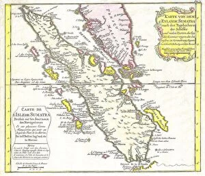
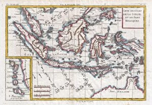
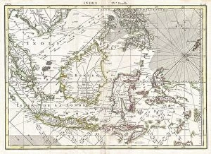
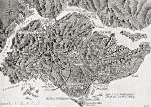
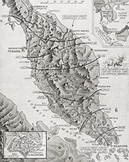
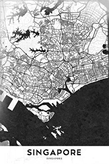
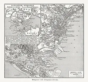
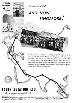
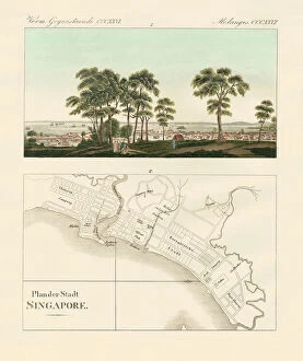
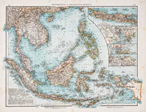
Maps of Singapore Asia are a collection that depict the geography and history of the island nation. They include detailed physical maps, topographic maps, political maps, and historical maps. These detailed maps provide an in-depth look at Singapore's unique culture, its people and its history. The physical map shows the main features of the country such as mountains, rivers and lakes while the topographic map provides a more detailed look at elevation changes across the country. The political map shows boundaries between countries and provinces while historical maps show how Singapore has changed over time. Maps of Singapore Asia provide an invaluable source for anyone interested in learning more about this fascinating country.
+

Our beautiful Wall Art and Photo Gifts include Framed Prints, Photo Prints, Poster Prints, Canvas Prints, Jigsaw Puzzles, Metal Prints and so much more

The Maps of Singapore Asia collection from Media Storehouse is a stunning compilation of vintage and contemporary maps that showcase the rich history and culture of Singapore. Our collection features a wide range of maps, including antique hand-drawn maps, colorful city plans, topographical charts, and satellite images. Each map in our collection is carefully selected for its unique style and historical significance. Some highlight important landmarks such as the Merlion statue or Marina Bay Sands while others depict old neighborhoods like Chinatown or Little India. The Maps of Singapore Asia collection offers an excellent opportunity to explore the evolution of this vibrant city-state over time. These beautiful wall art pieces are available in various sizes and formats to suit different preferences. Whether you're looking for a striking centerpiece for your living room or an elegant addition to your office decor, these framed prints will add character and charm to any space. With their exceptional quality and attention to detail, they make perfect gifts for anyone who loves travel or history.
+

What are Maps of Singapore Asia art prints?

Maps of Singapore Asia art prints are high-quality reproductions of vintage and contemporary maps depicting the city-state of Singapore, located in Southeast Asia. These art prints showcase the intricate details and features of Singapore's geography, including its streets, landmarks, waterways, and other important locations. These maps are not only visually stunning but also serve as valuable historical artifacts that provide insight into the evolution of Singapore over time. They make for great decorative pieces in homes or offices and can be used to add a touch of sophistication to any space. Whether you're a history buff or simply appreciate beautiful artwork, Maps of Singapore Asia art prints offer something for everyone. With their exceptional quality and attention to detail, they are sure to impress anyone who sees them.
+

What Maps of Singapore Asia art prints can I buy from Media Storehouse?

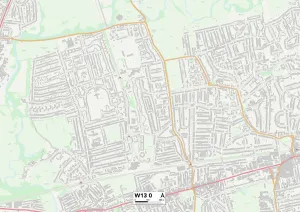
We offer a wide range of Maps of Singapore Asia art prints that are perfect for anyone who loves to explore the city-state. These maps come in various styles, sizes and designs, ranging from vintage to modern, colourful to monochrome. You can choose from different types of maps such as street maps, topographical maps or historical maps. Some popular options include the 'Singapore City Map' which showcases all major landmarks and attractions in the city centre; 'Vintage Singapore Map' which depicts how the island looked like back in 1924; and 'Singapore Topographic Map' which shows detailed elevation contours and terrain features. These Maps of Singapore Asia art prints are printed on high-quality paper using advanced printing techniques that ensure vibrant colours and sharp details. They make great gifts for friends or family members who have visited or lived in Singapore before, or simply as a beautiful addition to your home decor collection.
+

How do I buy Maps of Singapore Asia art prints?

To purchase Maps of Singapore Asia art prints from Media Storehouse, you can browse through our extensive collection of maps and select the one that suits your needs. Once you have found the map you want to buy, simply add it to your cart and proceed to checkout. You will then be prompted to enter your shipping and payment details. We offer a range of payment options including credit card, PayPal, and Apple Pay. We also offer international shipping so customers from all over the world can enjoy their beautiful art prints. Whether you are looking for a vintage map of Singapore or a modern interpretation of Asia's geography, we have something for everyone. Their high-quality prints are perfect for adding some color and character to any room in your home or office. So why wait? Start browsing today and find the perfect Maps of Singapore Asia art print for your space.
+

How much do Maps of Singapore Asia art prints cost?

We offer a wide range of Maps of Singapore Asia art prints that are available at varying prices. Our collection includes high-quality prints that feature detailed maps of the city-state and surrounding areas, showcasing the region's rich history and culture. The cost of our Maps of Singapore Asia art prints depends on several factors such as size, framing options, and print quality. We have a variety of sizes to choose from ranging from small to large formats suitable for any space or budget. Our team takes pride in providing affordable yet premium quality art prints that will surely add character and style to your home or office decor. Whether you're looking for a unique gift idea or simply want to enhance your living space with stunning wall art, our Maps of Singapore Asia art prints are an excellent choice. We invite you to browse through our extensive collection today and discover the perfect piece that suits your taste and preference.
+

How will my Maps of Singapore Asia art prints be delivered to me?

We take great care in ensuring that your Maps of Singapore Asia art prints are delivered to you safely and securely. We use high-quality packaging materials to protect your artwork during transit, including sturdy cardboard tubes for rolled prints and flat boxes for framed prints. Our delivery partners are reliable and experienced couriers who will handle your package with care. They will provide tracking information so you can keep an eye on the progress of your delivery. Once your order has been dispatched, you should receive an email notification with all the relevant details about your shipment. If there are any issues or delays with the delivery, our customer service team is always available to help resolve them quickly and efficiently. We want you to be completely satisfied with your purchase from Media Storehouse, which is why we go above and beyond to ensure that every aspect of the ordering process runs smoothly – including shipping and delivery.