Framed Print > Fine Art Finder > Schools > French School
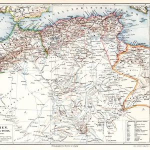
Framed Print : Map of Algeria, 1876 (litho) (b / w photo)
 (b / w photo)")
 (b / w photo)")

Please select a smaller print size for this image
![]()
Framed Photos from Fine Art Finder
Map of Algeria, 1876 (litho) (b / w photo)
XIR239505 Map of Algeria, 1876 (litho) (b/w photo) by French School, (19th century); Min. Defense - Service Historique de l Armee de Terre, France; French, out of copyright
Media ID 12768746
© www.bridgemanimages.com
Algerie Mediterranean North African Coast
21.5"x17.5" (55x44cm) Premium Frame
Discover the historical charm of the past with our Framed Prints from Media Storehouse. This captivating Map of Algeria, 1876 (litho) (b/w photo) by the French School is an intriguing piece of history. Originally published in the 19th century, this out-of-copyright map is a fascinating glimpse into the past, meticulously detailed and expertly preserved. Our high-quality framed prints bring the rich history of this map to life in your home or office, making it a perfect addition to any decor. Courtesy of Bridgeman Images and Fine Art Finder, this unique piece is sure to inspire wonder and curiosity. Order your Framed Print of Map of Algeria, 1876 today and travel back in time with every glance.
Framed and mounted 17x12 print. Professionally handmade full timber moulded frames are finished off with framers tape and come with a hanging solution on the back. Outer dimensions are 21.5x17.5 inches (546x444mm). Quality timber frame frame moulding (20mm wide and 30mm deep) with frame colours in your choice of black, white, or raw oak and a choice of black or white card mounts. Frames have a perspex front providing a virtually unbreakable glass-like finish which is easily cleaned with a damp cloth.
Contemporary Framed and Mounted Prints - Professionally Made and Ready to Hang
Estimated Image Size (if not cropped) is 41.8cm x 41.8cm (16.5" x 16.5")
Estimated Product Size is 54.6cm x 44.4cm (21.5" x 17.5")
These are individually made so all sizes are approximate
Artwork printed orientated as per the preview above, with landscape (horizontal) or portrait (vertical) orientation to match the source image.
EDITORS COMMENTS
This print showcases a historical gem - the "Map of Algeria, 1876". Created through lithography by an anonymous French School artist in the 19th century, this masterpiece is now preserved at the Ministry of Defense's Service Historique de l'Armee de Terre in France. With its copyright expired, this remarkable piece can be appreciated by all. The map takes us on a journey to North Africa's enchanting land, Algeria. Its intricate details beautifully capture the country's diverse topography and geographical features. From the rugged Atlas Mountains to the vast Sahara Desert, every contour is meticulously depicted. As we delve into this visual treasure trove, our eyes are drawn to Algeria's stunning coastline along the Mediterranean Sea. The artist skillfully portrays its jagged edges and gentle curves with utmost precision. This coastal region has witnessed countless stories unfold throughout history - tales of trade routes, conquests, and cultural exchanges that have shaped Algeria's rich heritage. This photograph print from Fine Art Finder allows us to appreciate not only the artistry behind this historic map but also invites us to explore Algeria's past. It serves as a reminder of how art transcends time and space; it connects us with distant lands and cultures long gone yet still alive within these delicate lines.
MADE IN AUSTRALIA
Safe Shipping with 30 Day Money Back Guarantee
FREE PERSONALISATION*
We are proud to offer a range of customisation features including Personalised Captions, Color Filters and Picture Zoom Tools
FREE COLORIZATION SERVICE
You can choose advanced AI Colorization for this picture at no extra charge!
SECURE PAYMENTS
We happily accept a wide range of payment options so you can pay for the things you need in the way that is most convenient for you
* Options may vary by product and licensing agreement. Zoomed Pictures can be adjusted in the Cart.