Photographic Print > Fine Art Finder > Schools > French School
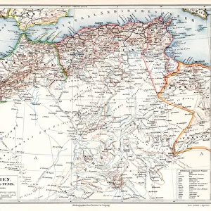
Photographic Print : Map of Algeria, 1876 (litho) (b / w photo)
 (b / w photo)")

Please select a smaller print size for this image
![]()
Photo Prints from Fine Art Finder
Map of Algeria, 1876 (litho) (b / w photo)
XIR239505 Map of Algeria, 1876 (litho) (b/w photo) by French School, (19th century); Min. Defense - Service Historique de l Armee de Terre, France; French, out of copyright
Media ID 12768746
© www.bridgemanimages.com
Algerie Mediterranean North African Coast
10"x8" (25x20cm) Photo Print
"Discover the intriguing history of Algeria with our vintage Map of Algeria, 1876 (XIR239505). This beautiful black and white photograph, taken from an original lithograph, offers a fascinating glimpse into the cartographic knowledge of the 19th century. Produced by the French School, this historical map was once part of the Min. Defense - Service Historique de l'Armee de Terre collection in France. Add an authentic touch to your home or office décor with this captivating piece of fine art from Media Storehouse's extensive photographic prints collection, now available through Bridgeman Images on Fine Art Finder."
Ideal for framing, Australian made Photo Prints are produced on high-quality 270 gsm lustre photo paper which has a subtle shimmer adding a touch of elegance, designed to enhance their visual appeal.
Our Photo Prints are in a large range of sizes and are printed on Archival Quality Paper for excellent colour reproduction and longevity. They are ideal for framing (our Framed Prints use these) at a reasonable cost. Alternatives include cheaper Poster Prints and higher quality Fine Art Paper, the choice of which is largely dependant on your budget.
Estimated Product Size is 25.4cm x 20.3cm (10" x 8")
These are individually made so all sizes are approximate
Artwork printed orientated as per the preview above, with landscape (horizontal) or portrait (vertical) orientation to match the source image.
EDITORS COMMENTS
This print showcases a historical gem - the "Map of Algeria, 1876". Created through lithography by an anonymous French School artist in the 19th century, this masterpiece is now preserved at the Ministry of Defense's Service Historique de l'Armee de Terre in France. With its copyright expired, this remarkable piece can be appreciated by all. The map takes us on a journey to North Africa's enchanting land, Algeria. Its intricate details beautifully capture the country's diverse topography and geographical features. From the rugged Atlas Mountains to the vast Sahara Desert, every contour is meticulously depicted. As we delve into this visual treasure trove, our eyes are drawn to Algeria's stunning coastline along the Mediterranean Sea. The artist skillfully portrays its jagged edges and gentle curves with utmost precision. This coastal region has witnessed countless stories unfold throughout history - tales of trade routes, conquests, and cultural exchanges that have shaped Algeria's rich heritage. This photograph print from Fine Art Finder allows us to appreciate not only the artistry behind this historic map but also invites us to explore Algeria's past. It serves as a reminder of how art transcends time and space; it connects us with distant lands and cultures long gone yet still alive within these delicate lines.
MADE IN AUSTRALIA
Safe Shipping with 30 Day Money Back Guarantee
FREE PERSONALISATION*
We are proud to offer a range of customisation features including Personalised Captions, Color Filters and Picture Zoom Tools
FREE COLORIZATION SERVICE
You can choose advanced AI Colorization for this picture at no extra charge!
SECURE PAYMENTS
We happily accept a wide range of payment options so you can pay for the things you need in the way that is most convenient for you
* Options may vary by product and licensing agreement. Zoomed Pictures can be adjusted in the Cart.