Framed Print > Fine Art Storehouse > The Magical World of Illustration > Palmer Illustrated Collection
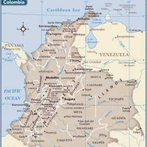
Framed Print : Map of South America 1856


![]()
Framed Photos from Fine Art Storehouse
Map of South America 1856
Colton and Fitchs Modern School Geography by George W. Fitch - New York 1856
Unleash your creativity and transform your space into a visual masterpiece!
THEPALMER
Media ID 13668779
© Roberto A Sanchez
Argentina Atlantic Ocean Backgrounds Brazil Colombia Direction Latin America Pacific Ocean Paper Patina Sepia Toned South America Textured Effect Uruguay Venezuela Obsolete Retro Styled
13.5"x11.5" (34x29cm) Premium Frame
Discover the historical charm of the past with our Framed Print of "Map of South America 1856" by THEPALMER from the Fine Art Storehouse collection. This exquisite piece is taken from Colton and Fitch's Modern School Geography by George W. Fitch, published in New York in 1856. Each detail of the map is beautifully preserved, transporting you back in time. The intricate borders, vivid colors, and meticulous labeling showcase the cartographic mastery of the era. Add this unique and educational piece to your home or office decor, and let the stories of history unfold before your eyes.
Framed and mounted 9x7 print. Professionally handmade full timber moulded frames are finished off with framers tape and come with a hanging solution on the back. Outer dimensions are 13.5x11.5 inches (34x29cm). Quality timber frame frame moulding (20mm wide and 30mm deep) with frame colours in your choice of black, white, or raw oak and a choice of black or white card mounts. Frames have a perspex front providing a virtually unbreakable glass-like finish which is easily cleaned with a damp cloth.
Contemporary Framed and Mounted Prints - Professionally Made and Ready to Hang
Estimated Image Size (if not cropped) is 21.4cm x 21.4cm (8.4" x 8.4")
Estimated Product Size is 29.2cm x 34cm (11.5" x 13.4")
These are individually made so all sizes are approximate
Artwork printed orientated as per the preview above, with landscape (horizontal) or portrait (vertical) orientation to match the source image.
EDITORS COMMENTS
This print takes us back in time to the year 1856, showcasing a beautifully detailed "Map of South America". The map is sourced from George W. Fitch's renowned publication, "Colton and Fitchs Modern School Geography" which was widely used during that era. With its retro-styled appearance and textured effect, this print exudes an air of nostalgia. The sepia-toned image highlights the intricate cartography of Latin America, featuring countries such as Venezuela, Uruguay, Colombia, Brazil, Argentina, and many more. The physical geography is meticulously depicted with mountains ranges, rivers snaking through vast landscapes, and coastlines bordering both the Pacific Ocean and Atlantic Ocean. Printed on aged paper with a patina finish further enhances its vintage charm. This piece serves as a testament to how maps were once essential tools for navigation before modern technology took over. Whether you are a history enthusiast or simply appreciate artistry in old illustrations like this one; this vertical illustration will transport you back in time while adding character to any space it graces. Let yourself be captivated by the obsolete beauty of this Map of South America from 1856 captured by THEPALMER at Fine Art Storehouse.
MADE IN AUSTRALIA
Safe Shipping with 30 Day Money Back Guarantee
FREE PERSONALISATION*
We are proud to offer a range of customisation features including Personalised Captions, Color Filters and Picture Zoom Tools
SECURE PAYMENTS
We happily accept a wide range of payment options so you can pay for the things you need in the way that is most convenient for you
* Options may vary by product and licensing agreement. Zoomed Pictures can be adjusted in the Cart.