Framed Print > Fine Art Storehouse > Map
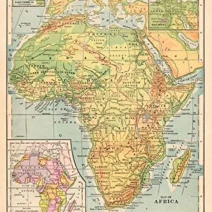
Framed Print : Africa map 1881


![]()
Framed Photos from Fine Art Storehouse
Africa map 1881
Harpers School Geography, New York, Harpers and Brothers, 1881
Unleash your creativity and transform your space into a visual masterpiece!
THEPALMER
Media ID 14756122
© This content is subject to copyright
Central Africa East Africa Madagascar Sahara
13.5"x11.5" (34x29cm) Premium Frame
Step back in time with our exquisite framed print of "Africa Map 1881" from ThePalmer's Harpers School Geography collection. Published by Harpers and Brothers, New York, in 1881, this vintage map offers a fascinating glimpse into the historical geography of Africa during the late 19th century. Each detail is beautifully preserved, from the intricate borders to the meticulously hand-drawn labels. Frame this captivating piece in your home or office to add a touch of history and character to your space, making it an excellent conversation starter. Embrace the rich history of cartography with our high-quality framed print from the Media Storehouse Fine Art collection.
Framed and mounted 9x7 print. Professionally handmade full timber moulded frames are finished off with framers tape and come with a hanging solution on the back. Outer dimensions are 13.5x11.5 inches (34x29cm). Quality timber frame frame moulding (20mm wide and 30mm deep) with frame colours in your choice of black, white, or raw oak and a choice of black or white card mounts. Frames have a perspex front providing a virtually unbreakable glass-like finish which is easily cleaned with a damp cloth.
Contemporary Framed and Mounted Prints - Professionally Made and Ready to Hang
Estimated Image Size (if not cropped) is 21.4cm x 21.4cm (8.4" x 8.4")
Estimated Product Size is 29.2cm x 34cm (11.5" x 13.4")
These are individually made so all sizes are approximate
Artwork printed orientated as per the preview above, with landscape (horizontal) or portrait (vertical) orientation to match the source image.
FEATURES IN THESE COLLECTIONS
> Fine Art Storehouse
> Map
> Historical Maps
EDITORS COMMENTS
In this print titled "Africa map 1881" we are transported back in time to the late 19th century, where cartography was still a blend of art and science. The intricate details and craftsmanship of this engraved image from Harpers School Geography, New York, Harpers and Brothers, 1881, truly capture the essence of Africa's diverse landscapes. The map showcases the vastness of the African continent with its rich tapestry of nations and regions. From Central Africa to East Africa, every corner is meticulously depicted with precision and accuracy. One cannot help but marvel at how much our understanding of geography has evolved since then. Notably featured on this vintage map is Madagascar, an island off the southeastern coast that adds a touch of mystery to the composition. As our eyes wander across the Sahara desert stretching across Northern Africa like a golden sea, we can almost feel its arid heat emanating from the print. "The Palmer" whose name accompanies this remarkable work, remains shrouded in anonymity. However, their talent for capturing historical maps in such exquisite detail is undeniable. As we gaze upon this piece from Fine Art Storehouse today, it serves as a reminder not only of Africa's geographical beauty but also as a testament to human curiosity and exploration throughout history. It invites us to reflect on how far we have come while appreciating those who paved the way for our modern understanding of our world's continents.
MADE IN AUSTRALIA
Safe Shipping with 30 Day Money Back Guarantee
FREE PERSONALISATION*
We are proud to offer a range of customisation features including Personalised Captions, Color Filters and Picture Zoom Tools
SECURE PAYMENTS
We happily accept a wide range of payment options so you can pay for the things you need in the way that is most convenient for you
* Options may vary by product and licensing agreement. Zoomed Pictures can be adjusted in the Cart.