Framed Print > Fine Art Storehouse > Map
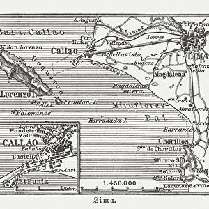
Framed Print : Antique map of Peru and Ecuador with plans for Lima


![]()
Framed Photos from Fine Art Storehouse
Antique map of Peru and Ecuador with plans for Lima
Unleash your creativity and transform your space into a visual masterpiece!
Hemera Technologies
Media ID 13609431
© Getty Images
18th Century 18th Century Style Columns Culture Custom Ecuador Equator Geography Natural Column Peru Plan Scene Scenes South America Text Vignette Vignettes Words Chatelain Lima Lima Peru Plans
21.5"x17.5" (55x44cm) Premium Frame
Step back in time with our exquisite Framed Print of the Antique Map of Peru and Ecuador with Plans for Lima, from the Fine Art Storehouse collection at Media Storehouse. This stunning piece, brought to you by Hemera Technologies, transports you to the past with intricate detail and authenticity. The antique map beautifully illustrates the territories of Peru and Ecuador, while the plans for Lima provide a fascinating glimpse into the historical layout of the city. Add this captivating work of art to your home or office to infuse it with a rich, historical charm.
Framed and mounted 17x12 print. Professionally handmade full timber moulded frames are finished off with framers tape and come with a hanging solution on the back. Outer dimensions are 21.5x17.5 inches (546x444mm). Quality timber frame frame moulding (20mm wide and 30mm deep) with frame colours in your choice of black, white, or raw oak and a choice of black or white card mounts. Frames have a perspex front providing a virtually unbreakable glass-like finish which is easily cleaned with a damp cloth.
Contemporary Framed and Mounted Prints - Professionally Made and Ready to Hang
Estimated Image Size (if not cropped) is 41.8cm x 41.8cm (16.5" x 16.5")
Estimated Product Size is 44.4cm x 54.6cm (17.5" x 21.5")
These are individually made so all sizes are approximate
Artwork printed orientated as per the preview above, with landscape (horizontal) or portrait (vertical) orientation to match the source image.
FEATURES IN THESE COLLECTIONS
> Fine Art Storehouse
> Map
> Historical Maps
EDITORS COMMENTS
This 18th-century print showcases an antique map of Peru and Ecuador, adorned with intricate plans for the vibrant city of Lima. A true treasure from the past, this archival piece takes us on a journey through time, revealing the rich cartography and historical significance of South America. The expertly engraved details bring to life the cultural heritage of these nations, as vignettes and scenes gracefully intertwine with columns of text. The vintage color image adds a touch of nostalgia, immersing viewers in a bygone era where exploration and discovery were paramount. As we delve into this remarkable artwork, our eyes are drawn to Lima's grandeur depicted in its meticulously crafted plans. The bustling streets come alive with custom scenes that capture the essence of daily life during that period. From historic landmarks to natural columns dotting the landscape, every element tells a story about Peru's fascinating history and physical geography. With its vertical composition and exquisite craftsmanship, this antique map invites us to appreciate not only its aesthetic beauty but also its educational value. It serves as a testament to human curiosity and our relentless pursuit of knowledge throughout centuries. Hemera Technologies has preserved this invaluable piece from their collection at Fine Art Storehouse so that we may continue to marvel at its splendor today.
MADE IN AUSTRALIA
Safe Shipping with 30 Day Money Back Guarantee
FREE PERSONALISATION*
We are proud to offer a range of customisation features including Personalised Captions, Color Filters and Picture Zoom Tools
SECURE PAYMENTS
We happily accept a wide range of payment options so you can pay for the things you need in the way that is most convenient for you
* Options may vary by product and licensing agreement. Zoomed Pictures can be adjusted in the Cart.