Framed Print > Fine Art Storehouse > Map
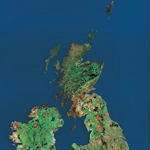
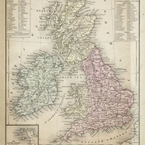
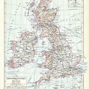
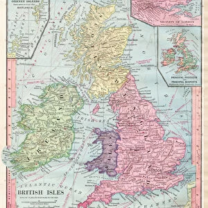
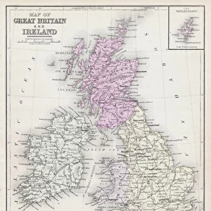
Framed Print : British isles map 1898


![]()
Framed Photos from Fine Art Storehouse
British isles map 1898
Unleash your creativity and transform your space into a visual masterpiece!
THEPALMER
Media ID 14549479
© This content is subject to copyright
13.5"x11.5" (34x29cm) Premium Frame
Discover the rich history of the British Isles with our stunningly detailed Framed Print of the British Isles Map from 1898 by THEPALMER, available at Media Storehouse from Fine Art Storehouse. This exquisite piece of cartography transports you back in time, showcasing the intricate details of the British Isles as they were known over a century ago. The high-quality print is expertly framed, adding an elegant touch to any room in your home or office. Bring a piece of historical cartography into your space and ignite conversations with this beautiful Framed Print from Media Storehouse.
Framed and mounted 9x7 print. Professionally handmade full timber moulded frames are finished off with framers tape and come with a hanging solution on the back. Outer dimensions are 13.5x11.5 inches (34x29cm). Quality timber frame frame moulding (20mm wide and 30mm deep) with frame colours in your choice of black, white, or raw oak and a choice of black or white card mounts. Frames have a perspex front providing a virtually unbreakable glass-like finish which is easily cleaned with a damp cloth.
Contemporary Framed and Mounted Prints - Professionally Made and Ready to Hang
Estimated Image Size (if not cropped) is 21.4cm x 21.4cm (8.4" x 8.4")
Estimated Product Size is 29.2cm x 34cm (11.5" x 13.4")
These are individually made so all sizes are approximate
Artwork printed orientated as per the preview above, with landscape (horizontal) or portrait (vertical) orientation to match the source image.
FEATURES IN THESE COLLECTIONS
> Fine Art Storehouse
> Map
> Historical Maps
EDITORS COMMENTS
This print showcases a meticulously detailed map of the British Isles from the year 1898. Created by THEPALMER, this piece captures the essence of historical cartography with its intricate lines and exquisite craftsmanship. The map itself is a testament to the rich heritage and cultural significance of the British Isles. As we delve into this snapshot of history, our eyes are immediately drawn to the beautifully rendered coastlines, rivers, and mountains that define these iconic lands. Each contour tells a story, revealing centuries-old towns and cities nestled amidst lush green landscapes. It is as if time has stood still within these borders. The sepia tones lend an air of nostalgia to this artwork, evoking a sense of reverence for times gone by. One can almost imagine explorers poring over similar maps in search of new territories or sailors relying on them for safe passage across treacherous waters. Beyond its aesthetic appeal lies an educational treasure trove; every inch teems with historical significance waiting to be discovered. This image serves as both a visual delight and an invaluable resource for historians, geographers, or anyone seeking insight into Britain's past. Whether displayed in a study room or adorning the walls of an art enthusiast's collection, this print invites us to explore not only geographical boundaries but also our own curiosity about how our world has evolved over time.
MADE IN AUSTRALIA
Safe Shipping with 30 Day Money Back Guarantee
FREE PERSONALISATION*
We are proud to offer a range of customisation features including Personalised Captions, Color Filters and Picture Zoom Tools
SECURE PAYMENTS
We happily accept a wide range of payment options so you can pay for the things you need in the way that is most convenient for you
* Options may vary by product and licensing agreement. Zoomed Pictures can be adjusted in the Cart.