Home > North America > United States of America > New York > New York > Maps
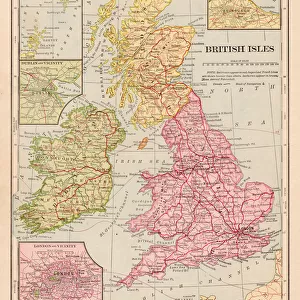
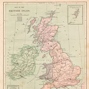
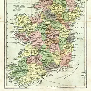
Map of the British isles 1869

![]()
Wall Art and Photo Gifts from Fine Art Storehouse
Map of the British isles 1869
Cornells Grammars-School Geography - S.S. Cornell - New York D. Appleton and Company 1869
Unleash your creativity and transform your space into a visual masterpiece!
THEPALMER
Media ID 13668819
© Roberto A Sanchez
Backgrounds British Culture Frame Grunge Grunge Image Technique Island Northern Ireland Paper Patina Republic Of Ireland Stained Textured Effect Obsolete Retro Styled
FEATURES IN THESE COLLECTIONS
> Europe
> Republic of Ireland
> Maps
> Europe
> United Kingdom
> England
> Maps
> Europe
> United Kingdom
> England
> York
> Europe
> United Kingdom
> Maps
> Europe
> United Kingdom
> Northern Ireland
> Maps
> Fine Art Storehouse
> The Magical World of Illustration
> Palmer Illustrated Collection
> Fine Art Storehouse
> Map
> Historical Maps
> Maps and Charts
> Early Maps
> Maps and Charts
> World
> North America
> United States of America
> New York
> New York
> Maps
EDITORS COMMENTS
This print showcases a vintage map of the British Isles from 1869, taken from "Cornells Grammars-School Geography" by S. S. Cornell. The retro-styled image exudes a sense of nostalgia and takes us back to a time when cartography was an art form in itself. The engraving, with its intricate details and engraved lines, adds to the charm of this piece. Although stained and showing signs of age, it only enhances the overall aesthetic appeal. Encased within an elegant frame, this print is reminiscent of old-world sophistication. The physical geography depicted on this map offers a fascinating glimpse into the past. It encompasses England, Northern Ireland, Scotland, Wales as well as parts of the Republic of Ireland. Each island is meticulously illustrated with textured effects that give it a unique character. With its grunge image technique and patina-like appearance, this illustration transports us to another era while celebrating British culture and heritage. Its vertical orientation allows for easy display in any space - be it your study or living room. "The Map of the British Isles 1869" by THEPALMER captures not just geographical information but also evokes emotions through its retro aesthetics and obsolete charm. Whether you are an avid collector or simply appreciate historical artifacts, this print promises to be a cherished addition to your collection without mentioning commercial use
MADE IN AUSTRALIA
Safe Shipping with 30 Day Money Back Guarantee
FREE PERSONALISATION*
We are proud to offer a range of customisation features including Personalised Captions, Color Filters and Picture Zoom Tools
SECURE PAYMENTS
We happily accept a wide range of payment options so you can pay for the things you need in the way that is most convenient for you
* Options may vary by product and licensing agreement. Zoomed Pictures can be adjusted in the Cart.