Framed Print > Asia > Malaysia > Maps
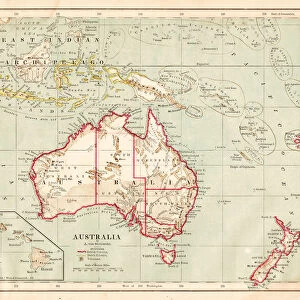
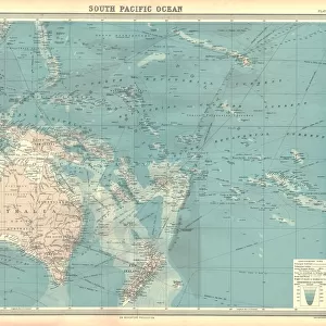
Framed Print : Map of Australia and Polynesia 1877


![]()
Framed Photos from Fine Art Storehouse
Map of Australia and Polynesia 1877
Warrens Common School Geography 1877
Unleash your creativity and transform your space into a visual masterpiece!
THEPALMER
Media ID 14824579
© This content is subject to copyright
Australasia Australia Indonesia Malaysia New Zealand Oceania Pacific Papua Polynesia Solomon Tasmania
13.5"x11.5" (34x29cm) Premium Frame
Discover the rich history of cartography with our stunning Framed Print of "Map of Australia and Polynesia 1877" by THEPALMER, available at Media Storehouse's Fine Art Storehouse. This exquisite piece, originally published in Warrens Common School Geography in 1877, showcases the intricate details of the maps from an era of exploration and discovery. The high-quality print is expertly framed to preserve its beauty and add a touch of historical charm to any room. Bring a piece of cartographic history into your home or office and start your own adventure in time with Media Storehouse's Framed Prints.
Framed and mounted 9x7 print. Professionally handmade full timber moulded frames are finished off with framers tape and come with a hanging solution on the back. Outer dimensions are 13.5x11.5 inches (34x29cm). Quality timber frame frame moulding (20mm wide and 30mm deep) with frame colours in your choice of black, white, or raw oak and a choice of black or white card mounts. Frames have a perspex front providing a virtually unbreakable glass-like finish which is easily cleaned with a damp cloth.
Contemporary Framed and Mounted Prints - Professionally Made and Ready to Hang
Estimated Image Size (if not cropped) is 21.4cm x 21.4cm (8.4" x 8.4")
Estimated Product Size is 34cm x 29.2cm (13.4" x 11.5")
These are individually made so all sizes are approximate
Artwork printed orientated as per the preview above, with landscape (horizontal) or portrait (vertical) orientation to match the source image.
FEATURES IN THESE COLLECTIONS
> Fine Art Storehouse
> Map
> Historical Maps
> Asia
> Indonesia
> Related Images
> Asia
> Malaysia
> Related Images
> Maps and Charts
> Related Images
> Oceania
> Australia
> Related Images
> Oceania
> New Zealand
> Maps
> Oceania
> New Zealand
> Related Images
EDITORS COMMENTS
In this print titled "Map of Australia and Polynesia 1877" we are transported back in time to the late 19th century, when exploration and discovery were at their peak. This vintage map, taken from Warrens Common School Geography in 1877, offers a fascinating glimpse into the geographical knowledge of that era. The intricate details on this map showcase not only the vastness of Australia but also its surrounding regions such as Malaysia, Tasmania, Australasia, Indonesia, New Zealand, Oceania, Pacific Islands including Papua and Polynesia. The artist behind this masterpiece is THEPALMER whose expertise shines through every line and contour. As we examine this historical artifact closely, it becomes apparent how much our understanding of these lands has evolved over time. It serves as a reminder of the tireless efforts made by early cartographers to unravel the mysteries of distant lands for future generations. The warm hues used in this print evoke a sense of nostalgia while simultaneously igniting curiosity about what life was like during that period. Whether displayed in an educational institution or within your own personal space, this artwork will undoubtedly spark conversations about history and geography. "The Map of Australia and Polynesia 1877" by THEPALMER is more than just a decorative piece; it is a window into our past. It invites us to explore forgotten territories with fresh eyes while appreciating the artistry involved in creating such detailed maps.
MADE IN AUSTRALIA
Safe Shipping with 30 Day Money Back Guarantee
FREE PERSONALISATION*
We are proud to offer a range of customisation features including Personalised Captions, Color Filters and Picture Zoom Tools
SECURE PAYMENTS
We happily accept a wide range of payment options so you can pay for the things you need in the way that is most convenient for you
* Options may vary by product and licensing agreement. Zoomed Pictures can be adjusted in the Cart.