Framed Print > North America > United States of America > New York > New York > Maps
Framed Print : Map New York and vicinities 1889


![]()
Framed Photos from Fine Art Storehouse
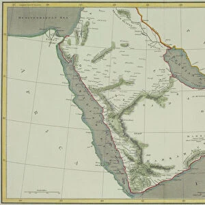
Map New York and vicinities 1889
Comprehensive Geography by James Monteith - American Book Company 1882, 1889
Unleash your creativity and transform your space into a visual masterpiece!
THEPALMER
Media ID 18357265
13.5"x11.5" (34x29cm) Premium Frame
Step back in time with our stunning Framed Print of "Map New York and Vicinities 1889" by THEPALMER from the Media Storehouse Fine Art Storehouse collection. This intricately detailed map, originally published in Comprehensive Geography by James Monteith with the American Book Company in 1882 and 1889, showcases the bustling streets and neighborhoods of New York City during a bygone era. Each print is meticulously framed in a classically designed frame, adding an elegant touch to any space. Bring history to life in your home or office with this unique and captivating piece.
Framed and mounted 9x7 print. Professionally handmade full timber moulded frames are finished off with framers tape and come with a hanging solution on the back. Outer dimensions are 13.5x11.5 inches (34x29cm). Quality timber frame frame moulding (20mm wide and 30mm deep) with frame colours in your choice of black, white, or raw oak and a choice of black or white card mounts. Frames have a perspex front providing a virtually unbreakable glass-like finish which is easily cleaned with a damp cloth.
Contemporary Framed and Mounted Prints - Professionally Made and Ready to Hang
Estimated Image Size (if not cropped) is 21.4cm x 21.4cm (8.4" x 8.4")
Estimated Product Size is 34cm x 29.2cm (13.4" x 11.5")
These are individually made so all sizes are approximate
Artwork printed orientated as per the preview above, with landscape (horizontal) or portrait (vertical) orientation to match the source image.
FEATURES IN THESE COLLECTIONS
> Fine Art Storehouse
> Map
> Historical Maps
> Maps and Charts
> Related Images
> North America
> United States of America
> New York
> New York
> Maps
> North America
> United States of America
> New York
> Related Images
EDITORS COMMENTS
In this print titled "Map New York and Vicinities 1889" we are transported back in time to the bustling streets of one of America's most iconic cities. The image, sourced from James Monteith's Comprehensive Geography published by the American Book Company in 1882 and updated in 1889, offers a unique glimpse into the past. The map itself is a testament to both artistry and historical accuracy. Every detail is meticulously crafted, showcasing the intricate network of roads, neighborhoods, and landmarks that defined New York City during this era. From Manhattan's towering skyscrapers to Brooklyn's charming brownstones, each borough tells its own story through its distinct architecture. As we explore this vintage cartographic gem captured by THEPALMER for Fine Art Storehouse, our imagination runs wild with thoughts of horse-drawn carriages traversing cobblestone streets and men donning top hats hurrying about their daily routines. It serves as a reminder of how much has changed over the years while also highlighting enduring symbols like Central Park or Lady Liberty that continue to shape New York's identity. This print not only appeals to history enthusiasts but also sparks curiosity among those eager to uncover hidden tales within these city blocks. Whether you're an avid collector or simply captivated by nostalgia, "Map New York and Vicinities 1889" transports us on an enchanting journey through time—a timeless piece that celebrates both artistry and history alike.
MADE IN AUSTRALIA
Safe Shipping with 30 Day Money Back Guarantee
FREE PERSONALISATION*
We are proud to offer a range of customisation features including Personalised Captions, Color Filters and Picture Zoom Tools
SECURE PAYMENTS
We happily accept a wide range of payment options so you can pay for the things you need in the way that is most convenient for you
* Options may vary by product and licensing agreement. Zoomed Pictures can be adjusted in the Cart.