Poster Print > North America > United States of America > New York > New York > Maps
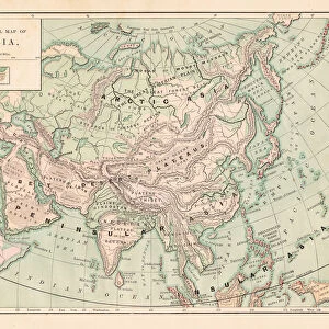
Poster Print : Map New York and vicinities 1889


![]()
Poster Prints from Fine Art Storehouse
Map New York and vicinities 1889
Comprehensive Geography by James Monteith - American Book Company 1882, 1889
Unleash your creativity and transform your space into a visual masterpiece!
THEPALMER
Media ID 18357265
A3 (42 x 29.7cm) Poster Print
Step back in time with our stunning vintage Map New York and Vicinities print from THEPALMER's Comprehensive Geography series, published by the American Book Company in 1889. This beautiful poster print showcases intricate details of New York City and its surroundings in 1889. Perfect for history enthusiasts, educators, or anyone who appreciates the beauty of historical maps. Bring a piece of the past into your home or office with this captivating and authentic poster print from Media Storehouse's Fine Art collection.
Premium quality poster prints are printed on luxurious semi-gloss satin 270 gsm paper. Our meticulously crafted poster prints offer an affordable option for decorating any space, making them ideal for living rooms, bedrooms, offices and beyond. To ensure your poster arrives in good condition, we roll and send them in strong mailing tubes.
Poster prints are budget friendly enlarged prints in standard poster paper sizes (A0, A1, A2, A3 etc). Whilst poster paper is sometimes thinner and less durable than our other paper types, they are still ok for framing and should last many years. Our Archival Quality Photo Prints and Fine Art Paper Prints are printed on higher quality paper and the choice of which largely depends on your budget.
Estimated Product Size is 42.6cm x 30.6cm (16.8" x 12")
These are individually made so all sizes are approximate
Artwork printed orientated as per the preview above, with landscape (horizontal) orientation to match the source image.
FEATURES IN THESE COLLECTIONS
> Fine Art Storehouse
> Map
> Historical Maps
> Maps and Charts
> Related Images
> North America
> United States of America
> New York
> New York
> Maps
> North America
> United States of America
> New York
> Related Images
EDITORS COMMENTS
In this print titled "Map New York and Vicinities 1889" we are transported back in time to the bustling streets of one of America's most iconic cities. The image, sourced from James Monteith's Comprehensive Geography published by the American Book Company in 1882 and updated in 1889, offers a unique glimpse into the past. The map itself is a testament to both artistry and historical accuracy. Every detail is meticulously crafted, showcasing the intricate network of roads, neighborhoods, and landmarks that defined New York City during this era. From Manhattan's towering skyscrapers to Brooklyn's charming brownstones, each borough tells its own story through its distinct architecture. As we explore this vintage cartographic gem captured by THEPALMER for Fine Art Storehouse, our imagination runs wild with thoughts of horse-drawn carriages traversing cobblestone streets and men donning top hats hurrying about their daily routines. It serves as a reminder of how much has changed over the years while also highlighting enduring symbols like Central Park or Lady Liberty that continue to shape New York's identity. This print not only appeals to history enthusiasts but also sparks curiosity among those eager to uncover hidden tales within these city blocks. Whether you're an avid collector or simply captivated by nostalgia, "Map New York and Vicinities 1889" transports us on an enchanting journey through time—a timeless piece that celebrates both artistry and history alike.
MADE IN AUSTRALIA
Safe Shipping with 30 Day Money Back Guarantee
FREE PERSONALISATION*
We are proud to offer a range of customisation features including Personalised Captions, Color Filters and Picture Zoom Tools
SECURE PAYMENTS
We happily accept a wide range of payment options so you can pay for the things you need in the way that is most convenient for you
* Options may vary by product and licensing agreement. Zoomed Pictures can be adjusted in the Cart.