Framed Print > Maps and Charts > Americas
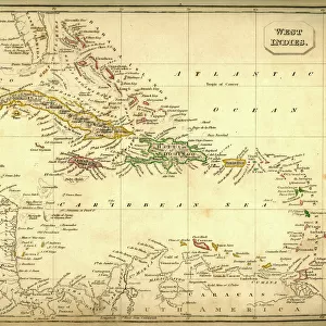
Framed Print : Map of West Indies and Central America 1900


![]()
Framed Photos from Fine Art Storehouse
Map of West Indies and Central America 1900
Meyers hand-Atlas Leipzig und Wien Verlag des Bibliographischen Instituts 1900
Unleash your creativity and transform your space into a visual masterpiece!
THEPALMER
Media ID 18106865
© 2014 Roberto Adrian Photography
13.5"x11.5" (34x29cm) Premium Frame
Step back in time with our exquisite framed print of the "Map of West Indies and Central America 1900" by THEPALMER from the Fine Art Storehouse collection. This stunning piece is taken from the esteemed Meyers Hand-Atlas published by the Bibliographischen Instituts Leipzig und Wien Verlag in 1900. The intricate details of this vintage map showcase the geography of the West Indies and Central America during a pivotal era in history. Add an air of sophistication and historical charm to any room with this beautifully framed and preserved piece of cartographical art.
Framed and mounted 9x7 print. Professionally handmade full timber moulded frames are finished off with framers tape and come with a hanging solution on the back. Outer dimensions are 13.5x11.5 inches (34x29cm). Quality timber frame frame moulding (20mm wide and 30mm deep) with frame colours in your choice of black, white, or raw oak and a choice of black or white card mounts. Frames have a perspex front providing a virtually unbreakable glass-like finish which is easily cleaned with a damp cloth.
Contemporary Framed and Mounted Prints - Professionally Made and Ready to Hang
Estimated Image Size (if not cropped) is 21.4cm x 21.4cm (8.4" x 8.4")
Estimated Product Size is 34cm x 29.2cm (13.4" x 11.5")
These are individually made so all sizes are approximate
Artwork printed orientated as per the preview above, with landscape (horizontal) or portrait (vertical) orientation to match the source image.
FEATURES IN THESE COLLECTIONS
> Fine Art Storehouse
> Map
> Historical Maps
EDITORS COMMENTS
This print showcases a historical gem, the "Map of West Indies and Central America 1900". Taken from the renowned Meyers hand-Atlas Leipzig und Wien Verlag des Bibliographischen Instituts 1900, this piece offers a fascinating glimpse into the cartographic mastery of yesteryears. Crafted by THEPALMER, this print captures the essence of an era long gone. The map itself is a testament to meticulous detail and precision. Every contour, river, and coastline has been intricately etched onto paper with utmost care. The vibrant colors used to delineate different territories evoke a sense of adventure and discovery that characterized this period in history. As we gaze upon this artwork, we are transported back in time to an age when exploration was at its peak. It serves as a visual reminder of how borders have shifted over time and how cultures have intermingled across these tropical lands. Beyond its historical significance, this print also stands as a testament to human curiosity and our innate desire for knowledge. It reminds us that maps not only guide us physically but also ignite our imagination by revealing uncharted territories waiting to be explored. "The Map of West Indies and Central America 1900" is more than just an antique relic; it represents the intersection between artistry and scientific accuracy. With every glance, it invites us on a journey through time while reminding us that even in today's digital age, there is still beauty in tangible works like these prints from Fine Art Storehouse
MADE IN AUSTRALIA
Safe Shipping with 30 Day Money Back Guarantee
FREE PERSONALISATION*
We are proud to offer a range of customisation features including Personalised Captions, Color Filters and Picture Zoom Tools
SECURE PAYMENTS
We happily accept a wide range of payment options so you can pay for the things you need in the way that is most convenient for you
* Options may vary by product and licensing agreement. Zoomed Pictures can be adjusted in the Cart.