Framed Print > Arts > Artists > D > Edward Duncan
Framed Print : Old Map of Acadie, Canada


![]()
Framed Photos from Fine Art Storehouse
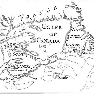
Old Map of Acadie, Canada
Vintage engraving of Old Map of Acadie. Acadia, French name for the former French colony today comprising roughly the Canadian provinces of Nova Scotia, New Brunswick, and Prince Edward Island
Unleash your creativity and transform your space into a visual masterpiece!
duncan1890
Media ID 18298713
© of Duncan P Walker
13.5"x11.5" (34x29cm) Premium Frame
Step back in time with our Old Map of Acadie, Canada Framed Print from the Media Storehouse Fine Art Storehouse collection. This vintage engraving beautifully captures the historical significance of Acadia, the French colony that once covered roughly the Canadian provinces of Nova Scotia, New Brunswick, and Prince Edward Island. The intricate details of the map are preserved in this high-quality framed print, making it a perfect addition to any home or office space. Bring a touch of history and charm to your decor with this captivating piece from the Fine Art Storehouse.
Framed and mounted 9x7 print. Professionally handmade full timber moulded frames are finished off with framers tape and come with a hanging solution on the back. Outer dimensions are 13.5x11.5 inches (34x29cm). Quality timber frame frame moulding (20mm wide and 30mm deep) with frame colours in your choice of black, white, or raw oak and a choice of black or white card mounts. Frames have a perspex front providing a virtually unbreakable glass-like finish which is easily cleaned with a damp cloth.
Contemporary Framed and Mounted Prints - Professionally Made and Ready to Hang
Estimated Image Size (if not cropped) is 21.4cm x 21.4cm (8.4" x 8.4")
Estimated Product Size is 34cm x 29.2cm (13.4" x 11.5")
These are individually made so all sizes are approximate
Artwork printed orientated as per the preview above, with landscape (horizontal) or portrait (vertical) orientation to match the source image.
FEATURES IN THESE COLLECTIONS
> Fine Art Storehouse
> Map
> Historical Maps
> Arts
> Artists
> D
> Edward Duncan
> Maps and Charts
> Related Images
> North America
> Canada
> Maps
> North America
> Canada
> Related Images
EDITORS COMMENTS
This print showcases an exquisite vintage engraving of the "Old Map of Acadie, Canada". Steeped in history and rich with cultural significance, this artwork takes us on a journey back in time to the former French colony known as Acadia. With its intricate details and delicate lines, the map offers a glimpse into the past, revealing the boundaries and geography of this remarkable region. Acadie, derived from its French name, encompasses what are now Nova Scotia, New Brunswick, and Prince Edward Island - provinces that have played a pivotal role in shaping Canadian heritage. As we gaze upon this mesmerizing piece, we can almost feel the echoes of centuries-old stories whispered by those who once called these lands home. The artist's careful restoration has breathed new life into this historical treasure. Every curve and contour is meticulously preserved to ensure authenticity while allowing us to appreciate its artistic beauty. The warm sepia tones evoke nostalgia for times long gone yet still cherished. Whether you are an avid historian or simply captivated by old-world charm, this Old Map of Acadie transports you to a different era. It serves as a reminder of our collective past and ignites curiosity about how these lands have evolved over time. With Duncan1890's masterful capture now available through Fine Art Storehouse, immerse yourself in the allure of Acadie – where culture meets artistry – right from your own walls.
MADE IN AUSTRALIA
Safe Shipping with 30 Day Money Back Guarantee
FREE PERSONALISATION*
We are proud to offer a range of customisation features including Personalised Captions, Color Filters and Picture Zoom Tools
SECURE PAYMENTS
We happily accept a wide range of payment options so you can pay for the things you need in the way that is most convenient for you
* Options may vary by product and licensing agreement. Zoomed Pictures can be adjusted in the Cart.