Framed Print > Aerial Photography > Related Images
Framed Print : New York State US State Road Map


![]()
Framed Photos from Fine Art Storehouse
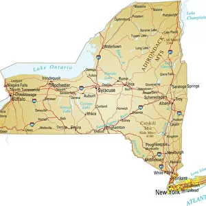
New York State US State Road Map
Vector Illustration of a Road Map of New York State State, USA.
All source data is in the public domain.
U.S. Geological Survey, US Topo
Used Layers:
USGS The National Map: National Hydrography Dataset (NHD)
USGS The National Map: National Transportation Dataset (NTD)
Unleash your creativity and transform your space into a visual masterpiece!
Frank Ramspott
Media ID 21006801
© Frank Ramspott, all rights reserved
Aerial View Brown Buffalo Computer Graphic Directly Above Hudson River Long Island New York City New York State Road Map Text Albany Cayuga Lake Digitally Generated Image Lake Champlain Rochester Seneca Lake Susquehanna River Syracuse Us State Watertown Yonkers
13.5"x11.5" (34x29cm) Premium Frame
Discover the beauty of New York State with our Framed Print of the "New York State US State Road Map" by Frank Ramspott from the Media Storehouse Fine Art collection. This stunning vector illustration, inspired by the U.S. Geological Survey, showcases the intricate details of New York's highways and roads in a fresh and artistic way. Bring the unique charm of the Empire State into your home or office with this conversational piece. The high-quality print is framed in a contemporary style, ensuring a sophisticated and timeless look. Explore the open roads and hidden gems of New York State with this beautiful and functional work of art.
Framed and mounted 9x7 print. Professionally handmade full timber moulded frames are finished off with framers tape and come with a hanging solution on the back. Outer dimensions are 13.5x11.5 inches (34x29cm). Quality timber frame frame moulding (20mm wide and 30mm deep) with frame colours in your choice of black, white, or raw oak and a choice of black or white card mounts. Frames have a perspex front providing a virtually unbreakable glass-like finish which is easily cleaned with a damp cloth.
Contemporary Framed and Mounted Prints - Professionally Made and Ready to Hang
Estimated Image Size (if not cropped) is 21.4cm x 21.4cm (8.4" x 8.4")
Estimated Product Size is 29.2cm x 34cm (11.5" x 13.4")
These are individually made so all sizes are approximate
Artwork printed orientated as per the preview above, with landscape (horizontal) or portrait (vertical) orientation to match the source image.
FEATURES IN THESE COLLECTIONS
> Fine Art Storehouse
> Map
> Reference Maps
> Aerial Photography
> Related Images
> Arts
> Contemporary art
> Digital artwork
> Street art
> Arts
> Landscape paintings
> Waterfall and river artworks
> River artworks
> Arts
> Portraits
> Pop art gallery
> Street art portraits
> Arts
> Street art graffiti
> Digital art
> Digital paintings
> Arts
> Street art graffiti
> Digital art
> Vector illustrations
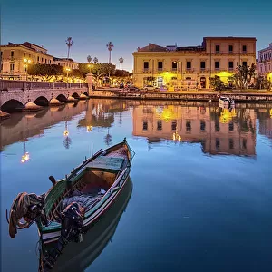
> Europe
> Italy
> Sicily
> Syracuse
> Maps and Charts
> Geological Map
> Maps and Charts
> Related Images
> North America
> United States of America
> Lakes
> Lake Champlain
EDITORS COMMENTS
This print showcases a meticulously detailed vector illustration of the New York State road map. With all source data in the public domain, this artwork is a testament to the incredible work of the U. S. Geological Survey and their topographic expertise. The map encompasses every aspect of New York State's geography, from its sprawling cities like New York City, Albany, Syracuse, Rochester, and Buffalo to its magnificent natural features such as Seneca Lake, Cayuga Lake, Oneida Lake, Hudson River, Lake Champlain, and Susquehanna River. The intricate network of streets and roads connects towns big and small across the state. Designed with precision and brought to life through digital generation techniques by Frank Ramspott, this visually stunning image offers an aerial view directly above New York State. The color palette predominantly consists of brown and red hues that beautifully represent both urban landscapes and natural elements. Perfect for enthusiasts of cartography or those with a deep appreciation for design aesthetics rooted in physical geography, this print is a must-have piece for any art collection. Its computer-generated graphics create a captivating visual experience that transports viewers into the heart of one of America's most iconic states – New York.
MADE IN AUSTRALIA
Safe Shipping with 30 Day Money Back Guarantee
FREE PERSONALISATION*
We are proud to offer a range of customisation features including Personalised Captions, Color Filters and Picture Zoom Tools
SECURE PAYMENTS
We happily accept a wide range of payment options so you can pay for the things you need in the way that is most convenient for you
* Options may vary by product and licensing agreement. Zoomed Pictures can be adjusted in the Cart.