Framed Print > Arts > Street art graffiti > Digital art > Vector illustrations
Framed Print : Richardson Texas US City Street Map


![]()
Framed Photos from Fine Art Storehouse
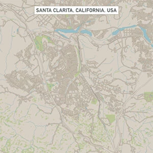
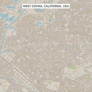
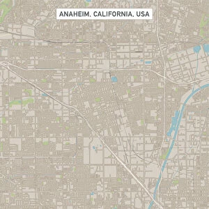
Richardson Texas US City Street Map
Vector Illustration of a City Street Map of Richardson, Texas, USA. Scale 1:60, 000.
All source data is in the public domain.
U.S. Geological Survey, US Topo
Used Layers:
USGS The National Map: National Hydrography Dataset (NHD)
USGS The National Map: National Transportation Dataset (NTD)
Unleash your creativity and transform your space into a visual masterpiece!
Frank Ramspott
Media ID 15192920
© Frank Ramspott, all rights reserved
Aerial View City Map Computer Graphic Directly Above Downtown District Gray Road Map Texas Text Digitally Generated Image Green Color Richardson White Color
13.5"x11.5" (34x29cm) Premium Frame
Add a touch of modern sophistication to your decor with the Media Storehouse Framed Print of "Richardson Texas US City Street Map" by Frank Ramspott from Fine Art Storehouse. This stunning vector illustration offers a detailed, 1:60,000 scale representation of the city streets of Richardson, Texas, USA. With all source data in the public domain and meticulously crafted, this framed print is not only an accurate geographical representation but also a beautiful work of art. Bring the charm of Richardson right into your home or office space.
Framed and mounted 9x7 print. Professionally handmade full timber moulded frames are finished off with framers tape and come with a hanging solution on the back. Outer dimensions are 13.5x11.5 inches (34x29cm). Quality timber frame frame moulding (20mm wide and 30mm deep) with frame colours in your choice of black, white, or raw oak and a choice of black or white card mounts. Frames have a perspex front providing a virtually unbreakable glass-like finish which is easily cleaned with a damp cloth.
Contemporary Framed and Mounted Prints - Professionally Made and Ready to Hang
Estimated Image Size (if not cropped) is 21.4cm x 21.4cm (8.4" x 8.4")
Estimated Product Size is 29.2cm x 34cm (11.5" x 13.4")
These are individually made so all sizes are approximate
Artwork printed orientated as per the preview above, with landscape (horizontal) or portrait (vertical) orientation to match the source image.
FEATURES IN THESE COLLECTIONS
> Fine Art Storehouse
> Map
> Street Maps
> Fine Art Storehouse
> Map
> USA Maps
> Aerial Photography
> Related Images
> Animals
> Insects
> Hemiptera
> Green Scale
> Arts
> Contemporary art
> Digital artwork
> Street art
> Arts
> Street art graffiti
> Digital art
> Digital paintings
> Arts
> Street art graffiti
> Digital art
> Vector illustrations
> Maps and Charts
> Geological Map
> Maps and Charts
> Related Images
> North America
> United States of America
> Lakes
> Related Images
> North America
> United States of America
> Maps
> North America
> United States of America
> Texas
> Related Images
EDITORS COMMENTS
This print showcases a detailed and visually stunning city street map of Richardson, Texas, USA. With a scale of 1:60,000, every intricate detail of this vibrant city is beautifully illustrated in vector format. The source data used for creating this masterpiece is from the public domain and provided by the U. S. Geological Survey's National Map. The various layers utilized in this artwork include the National Hydrography Dataset (NHD) and the National Transportation Dataset (NTD), both sourced from USGS' The National Map. These layers contribute to an accurate representation of the city's hydrography and transportation infrastructure. The image captures Richardson's downtown district along with its surrounding areas featuring a serene lake and river that add to its natural charm. The streets are clearly marked, making it easy to navigate through this bustling urban landscape. Designed using cutting-edge technology, this digitally generated image offers an aerial view directly above Richardson. The color palette includes shades of gray, blue, white, and green which enhance the visual appeal while maintaining clarity. Perfect for cartography enthusiasts or anyone seeking a unique piece of art showcasing their love for cities and maps, this print by Frank Ramspott is truly remarkable. It brings together elements of design and geography seamlessly into one captivating composition that will surely be admired by all who appreciate fine artistry.
MADE IN AUSTRALIA
Safe Shipping with 30 Day Money Back Guarantee
FREE PERSONALISATION*
We are proud to offer a range of customisation features including Personalised Captions, Color Filters and Picture Zoom Tools
SECURE PAYMENTS
We happily accept a wide range of payment options so you can pay for the things you need in the way that is most convenient for you
* Options may vary by product and licensing agreement. Zoomed Pictures can be adjusted in the Cart.