Framed Print > Europe > United Kingdom > England > Maps
Framed Print : Scilly Isles


![]()
Framed Photos from Fine Art Storehouse
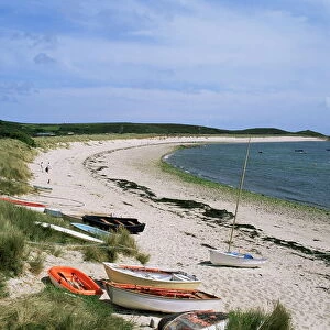
Scilly Isles
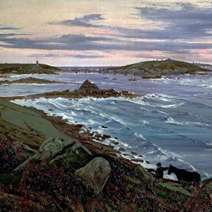
A map of the Scilly Isles, circa 1639. (Photo by Fox Photos/Hulton Archive/Getty Images)
Unleash your creativity and transform your space into a visual masterpiece!
Fox Photos
Media ID 11793034
© 2011 Getty Images
13.5"x11.5" (34x29cm) Premium Frame
Introducing the captivating Scilly Isles Framed Print from Media Storehouse's Fine Art Storehouse collection. This exquisite piece of art transports you to a bygone era with a vintage map of the Scilly Isles, dating back to circa 1639. This fascinating photograph from Fox Photos archives is expertly framed, adding an air of timeless elegance to your space. Immerse yourself in the rich history and beauty of the Scilly Isles with this stunning framed print. A perfect addition to any home or office, this unique piece is sure to inspire wonder and curiosity. Order yours today and bring a piece of history into your world.
Framed and mounted 9x7 print. Professionally handmade full timber moulded frames are finished off with framers tape and come with a hanging solution on the back. Outer dimensions are 13.5x11.5 inches (34x29cm). Quality timber frame frame moulding (20mm wide and 30mm deep) with frame colours in your choice of black, white, or raw oak and a choice of black or white card mounts. Frames have a perspex front providing a virtually unbreakable glass-like finish which is easily cleaned with a damp cloth.
Contemporary Framed and Mounted Prints - Professionally Made and Ready to Hang
Estimated Image Size (if not cropped) is 21.4cm x 21.4cm (8.4" x 8.4")
Estimated Product Size is 34cm x 29.2cm (13.4" x 11.5")
These are individually made so all sizes are approximate
Artwork printed orientated as per the preview above, with landscape (horizontal) or portrait (vertical) orientation to match the source image.
FEATURES IN THESE COLLECTIONS
> Fine Art Storehouse
> Fox Photo Library
> Fine Art Storehouse
> Photo Libraries
> Heritage Images
> Europe
> United Kingdom
> England
> Maps
> Maps and Charts
> Related Images
EDITORS COMMENTS
This print takes us back in time to the enchanting Scilly Isles, circa 1639. The map depicted here is a true testament to the rich history and allure of this archipelago off the southwestern coast of England. With its intricate details and delicate craftsmanship, it offers a glimpse into an era when cartography was both an art form and a means of exploration. The Scilly Isles have long been known for their breathtaking beauty, and this vintage map showcases their unique charm. Each island is meticulously outlined, revealing their individual shapes and sizes within the vast expanse of the Atlantic Ocean. It's fascinating to observe how these islands were positioned centuries ago, as they remain largely unchanged today. As we delve deeper into this historical piece, we are reminded of the importance of geography in understanding our world's past. The key provided allows us to decipher symbols that denote various landmarks or features on the map – from lighthouses guiding ships through treacherous waters to quaint villages dotting these idyllic islands. Thanks to Fox Photos' exceptional photography skills, this image captures not only the essence of a bygone era but also serves as a reminder that even in our modern age, there is still much wonderment left to explore. Whether you're an avid historian or simply appreciate fine art with historical significance, this print will transport you back in time while igniting your imagination about these mystical Scilly Isles.
MADE IN AUSTRALIA
Safe Shipping with 30 Day Money Back Guarantee
FREE PERSONALISATION*
We are proud to offer a range of customisation features including Personalised Captions, Color Filters and Picture Zoom Tools
SECURE PAYMENTS
We happily accept a wide range of payment options so you can pay for the things you need in the way that is most convenient for you
* Options may vary by product and licensing agreement. Zoomed Pictures can be adjusted in the Cart.