Framed Print > Arts > Artists > S > Walter Smalling
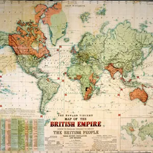
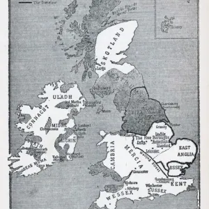
Framed Print : MAP: BRITISH EMPIRE, 1886. Map, 1886, of the British Empire by Walter Crane


![]()
Framed Photos from Granger
MAP: BRITISH EMPIRE, 1886. Map, 1886, of the British Empire by Walter Crane
MAP: BRITISH EMPIRE, 1886. Map, 1886, of the British Empire by Walter Crane. The small insert shows, in red, the extent of the British territories in 1786
Granger holds millions of images spanning more than 25,000 years of world history, from before the Stone Age to the dawn of the Space Age
Media ID 6620137
1886 Arts And Crafts Movement British Empire Colonialism Crane Walter World
21.5"x17.5" (55x44cm) Premium Frame
Discover the rich history of the British Empire with our stunning Framed Prints from Media Storehouse, featuring the iconic map by Walter Crane from The Granger Collection. This captivating map, created in 1886, showcases the vast expanse of the British Empire at the height of its power. The intricate details of the map are brought to life with vibrant colors, making it a perfect addition to any room in your home or office. The map includes an insert showing the earlier extent of British territories in red for an interesting comparison. Each Framed Print is carefully crafted with high-quality materials to ensure longevity and protection of the artwork. Transport yourself back in time and add a touch of history to your decor with this beautiful Framed Print of the British Empire by Walter Crane.
Framed and mounted 17x12 print. Professionally handmade full timber moulded frames are finished off with framers tape and come with a hanging solution on the back. Outer dimensions are 21.5x17.5 inches (546x444mm). Quality timber frame frame moulding (20mm wide and 30mm deep) with frame colours in your choice of black, white, or raw oak and a choice of black or white card mounts. Frames have a perspex front providing a virtually unbreakable glass-like finish which is easily cleaned with a damp cloth.
Contemporary Framed and Mounted Prints - Professionally Made and Ready to Hang
Estimated Image Size (if not cropped) is 41.8cm x 41.8cm (16.5" x 16.5")
Estimated Product Size is 54.6cm x 44.4cm (21.5" x 17.5")
These are individually made so all sizes are approximate
Artwork printed orientated as per the preview above, with landscape (horizontal) or portrait (vertical) orientation to match the source image.
FEATURES IN THESE COLLECTIONS
> Arts
> Artists
> C
> Walter Crane
> Arts
> Artists
> S
> Walter Smalling
> Maps and Charts
> British Empire Maps
> Maps and Charts
> Popular Maps
> Maps and Charts
> Related Images
> Maps and Charts
> World
> Granger Art on Demand
> Maps
EDITORS COMMENTS
This print showcases a historical map of the British Empire in 1886, masterfully created by Walter Crane. The intricate details and vibrant colors bring to life the vast expanse of territories under British rule during this era. As one explores the map, it becomes evident that the empire spanned across continents and oceans, leaving an indelible mark on world history. Walter Crane's artistic prowess is evident in this piece as he skillfully captures not only geographical accuracy but also conveys a sense of grandeur and power associated with colonialism. The inclusion of a small insert highlighting the extent of British territories in 1786 adds depth to our understanding of how much the empire expanded over time. This artwork serves as a poignant reminder of the late colonial period when Britain held significant global influence. It encapsulates an important chapter in world history, shedding light on both the achievements and controversies surrounding imperialism. As part of the Arts and Crafts movement, Walter Crane's work embodies his commitment to combining aesthetics with social commentary. This particular map print stands as a testament to his talent for merging artistry with education. The Granger Collection has once again curated an exceptional piece that invites viewers to delve into history through visual storytelling. Whether displayed at home or in educational settings, this print is sure to spark curiosity and ignite conversations about past empires' legacies.
MADE IN AUSTRALIA
Safe Shipping with 30 Day Money Back Guarantee
FREE PERSONALISATION*
We are proud to offer a range of customisation features including Personalised Captions, Color Filters and Picture Zoom Tools
SECURE PAYMENTS
We happily accept a wide range of payment options so you can pay for the things you need in the way that is most convenient for you
* Options may vary by product and licensing agreement. Zoomed Pictures can be adjusted in the Cart.