Framed Print > Europe > Republic of Ireland > Maps
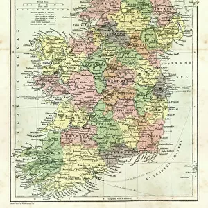
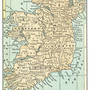
Framed Print : MAP: IRELAND, 1851. An engraved map of Ireland, 1851


![]()
Framed Photos from Granger
MAP: IRELAND, 1851. An engraved map of Ireland, 1851
Granger holds millions of images spanning more than 25,000 years of world history, from before the Stone Age to the dawn of the Space Age
Media ID 7514075
A2 Premium Frame with A3 Poster
Discover the rich history of Ireland with our stunning Framed Print of "MAP: IRELAND, 1851" from Media Storehouse and The Granger Collection. This captivating engraved map, originally from Granger Art on Demand, offers a glimpse into the past with intricate detail and vintage charm. Travel back in time as you explore the intricacies of Ireland's geography from 1851. Add this beautiful piece to your home or office decor to start a conversation about history and cartography. A perfect addition to any room, our high-quality framed print will surely be a conversation starter and a cherished piece in your collection.
Premium Paradise Wooden Range A2 Premium Poster Frame (62x45cm) with A3 Poster (42x30cm) and mounted behind a white matt board to make your photo really stand out. FSC Certified and Rainforest Alliance Certified for environmental, social, and economic sustainably. High transparency tempered glass window with a smooth finished frame. Great for filling empty walls, decorating blank spaces, or creating eye-catching gallery walls. Frames arrive ready to hang. Sent with secure, protective packaging. Smooth wooden veneer mimics the real wood look and feel with ultra-durable scratch resistance tempered glass.
Contemporary Framed and Mounted Prints - Professionally Made and Ready to Hang
Estimated Image Size (if not cropped) is 40.4cm x 40.4cm (15.9" x 15.9")
Estimated Product Size is 44.6cm x 62cm (17.6" x 24.4")
These are individually made so all sizes are approximate
Artwork printed orientated as per the preview above, with landscape (horizontal) or portrait (vertical) orientation to match the source image.
FEATURES IN THESE COLLECTIONS
> Europe
> Republic of Ireland
> Maps
> Maps and Charts
> Related Images
> Granger Art on Demand
> Maps
EDITORS COMMENTS
This print showcases an exquisite engraved map of Ireland from the year 1851. The intricate details and craftsmanship of this historical artifact transport us back to a time when cartography was both an art form and a vital tool for exploration. Every line, curve, and contour on this map tells a story of Ireland's rich history and geography. The middle section of the map captures the essence of Ireland with its lush green landscapes, rolling hills, and meandering rivers. It offers a glimpse into the country's diverse topography that has shaped its culture over centuries. As our eyes wander across the engraving, we can almost feel ourselves traversing through Irish towns and villages nestled along these winding waterways. Beyond its aesthetic appeal, this engraved map holds immense historical significance. It serves as a window into 19th-century Ireland – a period marked by political unrest, famine, and cultural revival. This piece is not just about geographical boundaries; it encapsulates the spirit of resilience embodied by the Irish people during challenging times. Thanks to Granger Art on Demand's meticulous preservation efforts, we are fortunate to have access to such remarkable artifacts like this one. Whether you are an avid historian or simply appreciate fine artistry, this print is sure to captivate your imagination while offering insights into Ireland's past like never before.
MADE IN AUSTRALIA
Safe Shipping with 30 Day Money Back Guarantee
FREE PERSONALISATION*
We are proud to offer a range of customisation features including Personalised Captions, Color Filters and Picture Zoom Tools
SECURE PAYMENTS
We happily accept a wide range of payment options so you can pay for the things you need in the way that is most convenient for you
* Options may vary by product and licensing agreement. Zoomed Pictures can be adjusted in the Cart.