Jigsaw Puzzle > Europe > Republic of Ireland > Maps
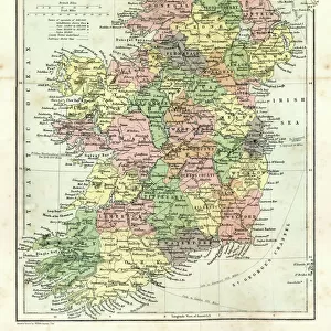
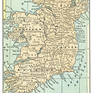
Jigsaw Puzzle : MAP: IRELAND, 1851. An engraved map of Ireland, 1851


![]()
Jigsaw Puzzles from Granger
MAP: IRELAND, 1851. An engraved map of Ireland, 1851
Granger holds millions of images spanning more than 25,000 years of world history, from before the Stone Age to the dawn of the Space Age
Media ID 7514075
Jigsaw Puzzle (1000 Pieces)
Discover the rich history of Ireland with our captivating jigsaw puzzle from Media Storehouse. This intricately designed puzzle features an engraved map of Ireland from 1851, taken from the esteemed archives of The Granger Collection. Immerse yourself in the details of this vintage map, showcasing the intricacies of Ireland's geography during that time. A perfect addition to any home or office, this puzzle is not only a fun and engaging activity, but also a beautiful way to learn and appreciate the history of this fascinating country. Bring the past to life, piece by piece, with our Media Storehouse jigsaw puzzle of "MAP: IRELAND, 1851."
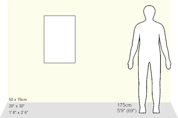
1000 piece puzzles are custom made in Australia and hand-finished on 100% recycled 1.6mm thick laminated puzzle boards. There is a level of repetition in jigsaw shapes with each matching piece away from its pair. The completed puzzle measures 76x50cm and is delivered packaged in an attractive presentation box specially designed to fit most mail slots with a unique magnetic lid
Jigsaw Puzzles are an ideal gift for any occasion
Estimated Product Size is 50.2cm x 76cm (19.8" x 29.9")
These are individually made so all sizes are approximate
Artwork printed orientated as per the preview above, with landscape (horizontal) or portrait (vertical) orientation to match the source image.
FEATURES IN THESE COLLECTIONS
> Granger Art on Demand
> Maps
> Europe
> Republic of Ireland
> Maps
> Maps and Charts
> Related Images
EDITORS COMMENTS
This print showcases an exquisite engraved map of Ireland from the year 1851. The intricate details and craftsmanship of this historical artifact transport us back to a time when cartography was both an art form and a vital tool for exploration. Every line, curve, and contour on this map tells a story of Ireland's rich history and geography. The middle section of the map captures the essence of Ireland with its lush green landscapes, rolling hills, and meandering rivers. It offers a glimpse into the country's diverse topography that has shaped its culture over centuries. As our eyes wander across the engraving, we can almost feel ourselves traversing through Irish towns and villages nestled along these winding waterways. Beyond its aesthetic appeal, this engraved map holds immense historical significance. It serves as a window into 19th-century Ireland – a period marked by political unrest, famine, and cultural revival. This piece is not just about geographical boundaries; it encapsulates the spirit of resilience embodied by the Irish people during challenging times. Thanks to Granger Art on Demand's meticulous preservation efforts, we are fortunate to have access to such remarkable artifacts like this one. Whether you are an avid historian or simply appreciate fine artistry, this print is sure to captivate your imagination while offering insights into Ireland's past like never before.
MADE IN AUSTRALIA
Safe Shipping with 30 Day Money Back Guarantee
FREE PERSONALISATION*
We are proud to offer a range of customisation features including Personalised Captions, Color Filters and Picture Zoom Tools
SECURE PAYMENTS
We happily accept a wide range of payment options so you can pay for the things you need in the way that is most convenient for you
* Options may vary by product and licensing agreement. Zoomed Pictures can be adjusted in the Cart.