Framed Print > Europe > United Kingdom > Wales > Maps
Framed Print : Map / England & Wales 1857


![]()
Framed Photos from Mary Evans Picture Library
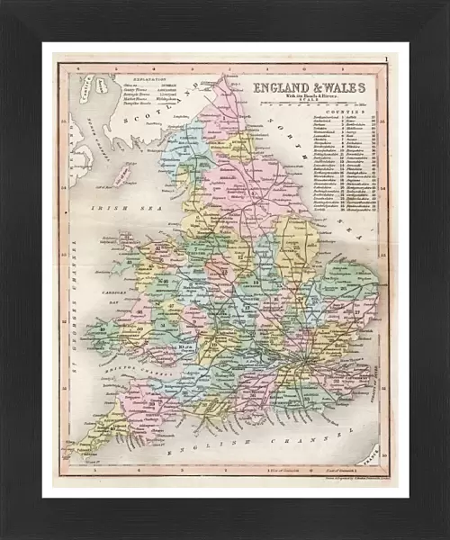
Map / England & Wales 1857
Map of England and Wales showing roads and rivers Date: circa 1857
Mary Evans Picture Library makes available wonderful images created for people to enjoy over the centuries
Media ID 14291473
© Mary Evans Picture Library
13.5"x11.5" (34x29cm) Premium Frame
Discover the rich history of England and Wales with our stunning Framed Prints from Media Storehouse. This exquisite piece showcases an intricately detailed map of the two countries, dating back to circa 1857. Sourced from Mary Evans Prints Online, this Rights Managed image beautifully illustrates the road networks and waterways of the time. Bring a piece of historical cartography into your home or office, and transport yourself back in time with every glance. Order now and add a touch of vintage charm to your space.
Framed and mounted 9x7 print. Professionally handmade full timber moulded frames are finished off with framers tape and come with a hanging solution on the back. Outer dimensions are 13.5x11.5 inches (34x29cm). Quality timber frame frame moulding (20mm wide and 30mm deep) with frame colours in your choice of black, white, or raw oak and a choice of black or white card mounts. Frames have a perspex front providing a virtually unbreakable glass-like finish which is easily cleaned with a damp cloth.
Contemporary Framed and Mounted Prints - Professionally Made and Ready to Hang
Estimated Image Size (if not cropped) is 21.4cm x 21.4cm (8.4" x 8.4")
Estimated Product Size is 29.2cm x 34cm (11.5" x 13.4")
These are individually made so all sizes are approximate
Artwork printed orientated as per the preview above, with landscape (horizontal) or portrait (vertical) orientation to match the source image.
FEATURES IN THESE COLLECTIONS
> Arts
> Landscape paintings
> Waterfall and river artworks
> River artworks
> Europe
> United Kingdom
> England
> Maps
> Europe
> United Kingdom
> England
> Posters
> Europe
> United Kingdom
> England
> Related Images
> Europe
> United Kingdom
> England
> Rivers
> Europe
> United Kingdom
> Wales
> Maps
> Europe
> United Kingdom
> Wales
> Posters
> Europe
> United Kingdom
> Wales
> Related Images
> Europe
> United Kingdom
> Wales
> Rivers
> Maps and Charts
> Related Images
EDITORS COMMENTS
1. Title: "A Journey Through Time: Exploring England & Wales in 1857 as Revealed in this Detailed Map" This antique map print, dating back to circa 1857, offers a fascinating glimpse into the geography of England and Wales during the Victorian era. The intricately detailed map showcases the roads and rivers that crisscrossed the two countries, providing valuable insight into the transportation networks of the time. The map's rich history is evident in its meticulous depiction of the British Isles, with the intricate winding roads and meandering rivers revealing the topography of the land. The map's vintage charm transports us back to an era when travel was an adventure, and the exploration of new territories was a source of wonder and discovery. England and Wales in 1857 were undergoing significant changes, with the Industrial Revolution transforming the landscape and the population continuing to grow. This map serves as a testament to the progress that had been made, as well as a reminder of the challenges and complexities of navigating the country during this period. The map's antique aesthetic, with its intricate border design and use of muted colors, adds to its allure, making it a beautiful addition to any home or office. Whether used as a conversation starter, a decorative piece, or a research tool, this map is sure to captivate anyone with an interest in history, geography, or the Victorian era. This map is not only a valuable historical document but also a reminder of the rich cultural heritage that makes up the fabric of England and Wales. It invites us to explore the past and to appreciate the evolution of our world over time.
MADE IN AUSTRALIA
Safe Shipping with 30 Day Money Back Guarantee
FREE PERSONALISATION*
We are proud to offer a range of customisation features including Personalised Captions, Color Filters and Picture Zoom Tools
SECURE PAYMENTS
We happily accept a wide range of payment options so you can pay for the things you need in the way that is most convenient for you
* Options may vary by product and licensing agreement. Zoomed Pictures can be adjusted in the Cart.