Framed Print > Europe > United Kingdom > England > London > Museums > National Army Museum
Framed Print : Map: The Invasions of England and Ireland - 1627


![]()
Framed Photos from Mary Evans Picture Library
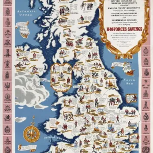
Map: The Invasions of England and Ireland - 1627
Map: The Invasions of England and Ireland With al [sic] their Civill [sic] Wars since the Conquest Corn Danckertsz sculpsit [London] George Humble, 1627 (c). Framed hand-coloured and engraved map by John Speed. Depicts the locations of various battles, invasions and naval engagements in the British Isles since 1066, including the Wars of the Roses (1455-1485) and the Spanish Armada (1586-1588). Date: circa 1627
Mary Evans Picture Library makes available wonderful images created for people to enjoy over the centuries
Media ID 14404162
© The National Army Museum / Mary Evans Picture Library
1627 Battles Conquest Corn Depicts Engraved Framed Humble Invasions Locations Speed Wars Sculpsit
13.5"x11.5" (34x29cm) Premium Frame
Step back in time with our exquisite Framed Prints from the Media Storehouse collection. This captivating piece, titled "Map: The Invasions of England and Ireland - 1627," is an intricately detailed antique map showcasing the invasions of England and Ireland, complete with their civil wars. Originally sculpted by Cornelis Danckerts and published in London by George Humble in 1627, this rare map is now available as a beautiful framed print, adding a touch of history and sophistication to any room. With its intricate details and rich history, this is a must-have for history buffs, map collectors, and those who appreciate the beauty of antique prints.
Framed and mounted 9x7 print. Professionally handmade full timber moulded frames are finished off with framers tape and come with a hanging solution on the back. Outer dimensions are 13.5x11.5 inches (34x29cm). Quality timber frame frame moulding (20mm wide and 30mm deep) with frame colours in your choice of black, white, or raw oak and a choice of black or white card mounts. Frames have a perspex front providing a virtually unbreakable glass-like finish which is easily cleaned with a damp cloth.
Contemporary Framed and Mounted Prints - Professionally Made and Ready to Hang
Estimated Image Size (if not cropped) is 21.4cm x 21.4cm (8.4" x 8.4")
Estimated Product Size is 34cm x 29.2cm (13.4" x 11.5")
These are individually made so all sizes are approximate
Artwork printed orientated as per the preview above, with landscape (horizontal) or portrait (vertical) orientation to match the source image.
FEATURES IN THESE COLLECTIONS
> Arts
> Artists
> S
> John Speed
> Europe
> Republic of Ireland
> Maps
> Europe
> Spain
> Related Images
> Europe
> United Kingdom
> England
> London
> Museums
> British Library
> Europe
> United Kingdom
> England
> London
> Museums
> British Museum
> Europe
> United Kingdom
> England
> London
> Museums
> National Army Museum
> Europe
> United Kingdom
> England
> London
> Sights
> British Museum
> Europe
> United Kingdom
> England
> Maps
EDITORS COMMENTS
This intricately detailed and beautifully hand-colored map, titled "The Invasions of England and Ireland with their Civil Wars since the Conquest," dates back to circa 1627. The map was created by the renowned English cartographer John Speed, with the sculpture by Cornelis Danckerts and published by George Humble in London. The map offers a comprehensive depiction of significant battles, invasions, and naval engagements that have shaped the history of England and Ireland since the Norman Conquest of 1066. The map covers the British Isles and highlights key locations such as Edinburgh, Dublin, London, and various other cities and towns. Notable historical events marked on the map include the Wars of the Roses (1455-1485), which saw the struggle for the English throne between the House of Lancaster and the House of York, and the Spanish Armada (1586-1588), a failed invasion attempt by the Spanish fleet under Philip II of Spain. The map's intricate detail and historical significance make it a valuable resource for scholars, historians, and anyone interested in the rich history of England and Ireland. The map's borders are adorned with elaborate decorative elements, and the hand-coloring adds an extra layer of visual interest. This map is a testament to the meticulous craftsmanship and historical knowledge of its creators, providing a fascinating glimpse into the past.
MADE IN AUSTRALIA
Safe Shipping with 30 Day Money Back Guarantee
FREE PERSONALISATION*
We are proud to offer a range of customisation features including Personalised Captions, Color Filters and Picture Zoom Tools
SECURE PAYMENTS
We happily accept a wide range of payment options so you can pay for the things you need in the way that is most convenient for you
* Options may vary by product and licensing agreement. Zoomed Pictures can be adjusted in the Cart.