Framed Print > Animals > Extinct > Dinosaurs
Framed Print : Map of the continents and seas in the Upper Triassic


![]()
Framed Photos from Mary Evans Picture Library
Map of the continents and seas in the Upper Triassic
Map of the continents and seas in the Upper Triassic period. North America, Atlantis, Europe, Asia, Gondwanaland. Colour print after an illustration from Wilhelm Bolsches Das Leben der Urwelt, Prehistoric Life, Georg Dollheimer, Leipzig, 1932
Mary Evans Picture Library makes available wonderful images created for people to enjoy over the centuries
Media ID 23381556
© Florilegius
Bolsche Continents Creature Cretaceous Dinosaur Dinosaurs Diplodocus Extinct Genus Giant Hugo Leben Lower Maage Paleontology Prehistoric Prehistory Seas Swamp Triassic Urwelt Wilhelm Wolff Upper
A2 Premium Frame with A3 Poster
Step back in time with our stunning Framed Print from the Media Storehouse collection, featuring a captivating illustration of the continents and seas during the Upper Triassic period. This beautiful color print, sourced from Mary Evans Picture Library via Mary Evans Prints Online, depicts the intriguing geological landscape of North America, Atlantis, Europe, Asia, and Gondwanaland as they appeared over 200 million years ago. Bring a touch of history and scientific wonder into your home or office with this engaging and educational piece of art. Order your Framed Print today and start a conversation about the fascinating world that came before us.
Premium Paradise Wooden Range A2 Premium Poster Frame (62x45cm) with A3 Poster (42x30cm) and mounted behind a white matt board to make your photo really stand out. FSC Certified and Rainforest Alliance Certified for environmental, social, and economic sustainably. High transparency tempered glass window with a smooth finished frame. Great for filling empty walls, decorating blank spaces, or creating eye-catching gallery walls. Frames arrive ready to hang. Sent with secure, protective packaging. Smooth wooden veneer mimics the real wood look and feel with ultra-durable scratch resistance tempered glass.
Contemporary Framed and Mounted Prints - Professionally Made and Ready to Hang
Estimated Image Size (if not cropped) is 40.4cm x 40.4cm (15.9" x 15.9")
Estimated Product Size is 62cm x 44.6cm (24.4" x 17.6")
These are individually made so all sizes are approximate
Artwork printed orientated as per the preview above, with landscape (horizontal) or portrait (vertical) orientation to match the source image.
FEATURES IN THESE COLLECTIONS
> Animals
> Extinct
> Dinosaurs
> Asia
> Related Images
> Maps and Charts
> Related Images
> North America
> Related Images
> Mary Evans Prints Online
> New Images August 2021
EDITORS COMMENTS
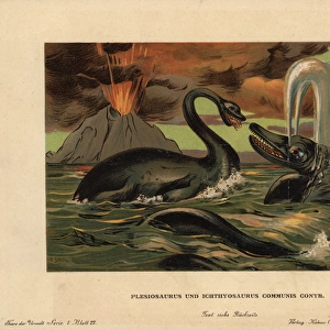
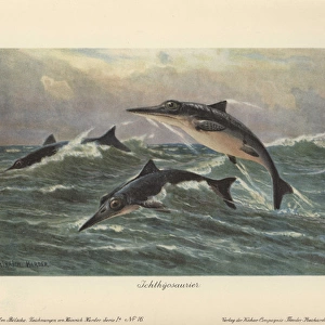
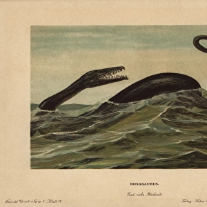
This color print depicts a map of the continents and seas during the Upper Triassic period, around 245 to 208 million years ago. At this time, the world looked dramatically different from today. North America is shown as a single landmass, while Europe and Asia were connected, forming part of the supercontinent Pangaea. To the south, the vast landmass of Gondwanaland began to split apart, eventually giving rise to the continents of South America, Antarctica, Australia, and Africa. The map also features various bodies of water, including the vast Tethys Sea, which stretched from the Atlantic Ocean to the Indian Ocean. In the northern hemisphere, a large inland sea covered much of what is now the western United States. Swamps and lakes dotted the landscape, providing habitats for early plant and animal life. This map is an illustration from Wilhelm Bolsche's Das Leben der Urwelt (Prehistoric Life), published in Leipzig, Germany, in 1932. The map was created by Hugo Maage, W. Wolff, and M. Maage. At the time, such illustrations were essential tools for paleontologists and zoologists studying the prehistory of life on Earth. The Upper Triassic period is an intriguing time in Earth's history, marked by the emergence of many groups of animals that would later dominate the planet, including the dinosaurs. One of the most famous dinosaurs, Diplodocus, a long-necked, plant-eating giant, roamed the lands that would later become North America. Marine creatures, such as ammonites and ichthyosaurs, thrived in the seas. Although the map does not show any of these extinct creatures, it offers a fascinating glimpse into the world they inhabited, a world that was vastly different from the one we know today.
MADE IN AUSTRALIA
Safe Shipping with 30 Day Money Back Guarantee
FREE PERSONALISATION*
We are proud to offer a range of customisation features including Personalised Captions, Color Filters and Picture Zoom Tools
SECURE PAYMENTS
We happily accept a wide range of payment options so you can pay for the things you need in the way that is most convenient for you
* Options may vary by product and licensing agreement. Zoomed Pictures can be adjusted in the Cart.