Framed Print > Arts > Artists > H > Franz Hogenberg
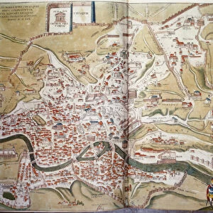
Framed Print : Spain. Castile and Leon. Burgos. Map, 1576 at Civitates


![]()
Framed Photos from Mary Evans Picture Library
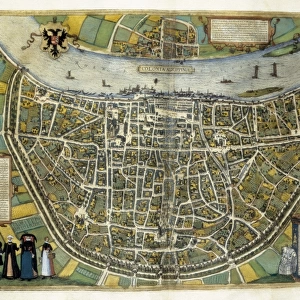
Spain. Castile and Leon. Burgos. Map, 1576 at Civitates
Spain. Castile and Leon. Burgos. Map, 1576 at Civitates Orbis Terrarum by Georg Braun (1541-1622) and Franz Hogenberg (1536-1590). Salamanca University Library
Mary Evans Picture Library makes available wonderful images created for people to enjoy over the centuries
Media ID 14406726
© Thaliastock / Mary Evans
1576 Burgos Cartography Castile Castilia Castilian Cattle Civitates Crop Donkey Farmer Flock Hogenberg Leon Livestock Orbis Raising Terrarum
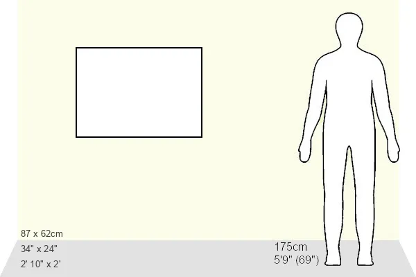
A1 Premium Frame with A2 Poster
Step back in time with our exquisite Framed Prints from Media Storehouse. This captivating piece showcases an intricately detailed map of Burgos, Castile and Leon, Spain from the year 1576. Originally published in the renowned Civitates Orbis Terrarum atlas, created by Georg Braun and Franz Hogenberg, this vintage map is now available as a beautiful framed print. The intricate lines and vibrant colors of the map transport you to a bygone era, making it a stunning addition to any room in your home or office. With our high-quality printing and elegant framing options, you can proudly display this piece as a conversation starter and a testament to historical cartography.
Premium Paradise Wooden Range A1 Premium Poster Frame (86x62cm) with A2 Poster (59x42cm) and mounted behind a white matt board to make your photo really stand out. FSC Certified and Rainforest Alliance Certified for environmental, social, and economic sustainably. High transparency tempered glass window with a smooth finished frame. Great for filling empty walls, decorating blank spaces, or creating eye-catching gallery walls. Frames arrive ready to hang. Sent with secure, protective packaging. Smooth wooden veneer mimics the real wood look and feel with ultra-durable scratch resistance tempered glass.
Contemporary Framed and Mounted Prints - Professionally Made and Ready to Hang
Estimated Image Size (if not cropped) is 57.8cm x 57.8cm (22.8" x 22.8")
Estimated Product Size is 86.6cm x 62cm (34.1" x 24.4")
These are individually made so all sizes are approximate
Artwork printed orientated as per the preview above, with landscape (horizontal) or portrait (vertical) orientation to match the source image.
FEATURES IN THESE COLLECTIONS
> Animals
> Farm
> Cattle
> Related Images
> Animals
> Farm
> Donkeys
> Related Images
> Animals
> Mammals
> Bovidae
> Cattle
> Arts
> Artists
> H
> Franz Hogenberg
> Arts
> Landscape paintings
> Landscape art
> Landscape paintings
> Europe
> France
> Canton
> Landes
> Europe
> Spain
> Related Images
> Maps and Charts
> Related Images
EDITORS COMMENTS
This map print, titled "Burgos" from the atlas "Civitates Orbis Terrarum," was created by the renowned cartographers Georg Braun and Franz Hogenberg in the year 1576. The map is part of the extensive collection housed in the historic Salamanca University Library in Spain. The map provides an intriguing glimpse into the geography and topography of Castile and Leon, specifically the province of Burgos during the 16th century. The intricate detail and vibrant colors of the map bring the landscape to life, depicting a diverse range of landscapes, from rolling hills and lush fields to sprawling cities and bustling markets. The map features several notable landmarks, including the city of Burgos, situated at the heart of the region. The city is shown with its impressive cathedral, surrounded by defensive walls and fortifications. The map also highlights several other towns and villages, connected by winding roads and rivers. The rural areas of the map are filled with images of farmers and herdsmen tending to their livestock, with cattle and sheep grazing in the fields. The use of color adds depth and texture to the map, with different crops depicted in various shades of green and brown. This map is a testament to the remarkable cartographic skills of Braun and Hogenberg, who meticulously documented the world as it was known at the time. It offers a fascinating window into the history and culture of Castile and Leon during the late 16th century, providing valuable insights into the daily life and economic activities of the region.
MADE IN AUSTRALIA
Safe Shipping with 30 Day Money Back Guarantee
FREE PERSONALISATION*
We are proud to offer a range of customisation features including Personalised Captions, Color Filters and Picture Zoom Tools
SECURE PAYMENTS
We happily accept a wide range of payment options so you can pay for the things you need in the way that is most convenient for you
* Options may vary by product and licensing agreement. Zoomed Pictures can be adjusted in the Cart.