Framed Print > Europe > Spain > Maps
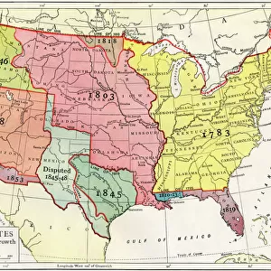
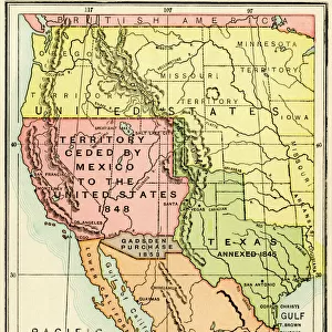
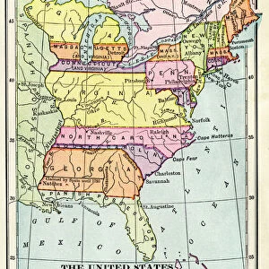
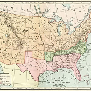
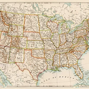
Framed Print : US territorial acquisition during the 1800s


![]()
Framed Photos from North Wind
US territorial acquisition during the 1800s
Map showiing the territorial growth of the continental US 1776 to 1899.
Hand-colored woodcut of a 19th-century illustration
North Wind Picture Archives brings history to life with stock images and hand-colored illustrations
Media ID 5877358
© North Wind Picture Archives
America Border Boundary Louisiana Louisiana Purchase Louisiana Territory Mexico New World Oregon Oregon Territory Spanish States Territory Texas War Of 1812 Annexation
21.5"x17.5" (55x44cm) Premium Frame
Step back in time with our captivating Framed Print from Media Storehouse, featuring an intricately detailed hand-colored woodcut of US territorial acquisition during the 1800s. This vintage map from North Wind Picture Archives showcases the growth of the continental United States from 1776 to 1899, offering a fascinating glimpse into history. Perfectly preserved behind a clear acrylic face and set in a classic frame, this print is a must-have for history enthusiasts and those who appreciate the beauty of antique cartography. Add this unique piece to your home or office décor and let the stories of the past come to life.
Framed and mounted 17x12 print. Professionally handmade full timber moulded frames are finished off with framers tape and come with a hanging solution on the back. Outer dimensions are 21.5x17.5 inches (546x444mm). Quality timber frame frame moulding (20mm wide and 30mm deep) with frame colours in your choice of black, white, or raw oak and a choice of black or white card mounts. Frames have a perspex front providing a virtually unbreakable glass-like finish which is easily cleaned with a damp cloth.
Contemporary Framed and Mounted Prints - Professionally Made and Ready to Hang
Estimated Image Size (if not cropped) is 41.8cm x 41.8cm (16.5" x 16.5")
Estimated Product Size is 54.6cm x 44.4cm (21.5" x 17.5")
These are individually made so all sizes are approximate
Artwork printed orientated as per the preview above, with landscape (horizontal) or portrait (vertical) orientation to match the source image.
FEATURES IN THESE COLLECTIONS
> Europe
> Spain
> Related Images
> Maps and Charts
> Spain
> Maps and Charts
> World
> North America
> Mexico
> Related Images
> North America
> Related Images
> North Wind Picture Archives
> American history
> North Wind Picture Archives
> Maps
EDITORS COMMENTS
This hand-colored woodcut print showcases the remarkable territorial growth of the United States during the 1800s. Spanning from 1776 to 1899, this vintage map provides a visual narrative of America's expansion and acquisition of new lands. The intricate illustration depicts various key moments in history that shaped the nation we know today. Starting with the original thirteen colonies, this map highlights significant events such as the Louisiana Purchase, which doubled America's size overnight in 1803. It also portrays Texas' annexation and its subsequent border disputes with Mexico, leading to conflicts like the Mexican-American War. The Oregon Territory is prominently featured, representing one of many instances where negotiations determined borders between nations. Spanish territories are clearly marked on this map too, reminding us of their influence before ceding Florida to the United States in 1819. As you explore this historical masterpiece, it becomes evident that each boundary represents a story - stories of exploration, diplomacy, conflict, and ambition. This artwork serves as a testament to our rich heritage and traditional values deeply rooted in American history. With its vibrant colors and meticulous details capturing every state line and region acquired over time – including notable purchases like Gadsden Purchase – this print offers an engaging glimpse into how North America transformed throughout these transformative centuries. Whether you're an art enthusiast or a history buff seeking insight into America's territorial development during the New World era; this stunning woodcut print will undoubtedly captivate your imagination for hours on end.
MADE IN AUSTRALIA
Safe Shipping with 30 Day Money Back Guarantee
FREE PERSONALISATION*
We are proud to offer a range of customisation features including Personalised Captions, Color Filters and Picture Zoom Tools
SECURE PAYMENTS
We happily accept a wide range of payment options so you can pay for the things you need in the way that is most convenient for you
* Options may vary by product and licensing agreement. Zoomed Pictures can be adjusted in the Cart.