Framed Print > Europe > United Kingdom > England > London > Towns > West Green
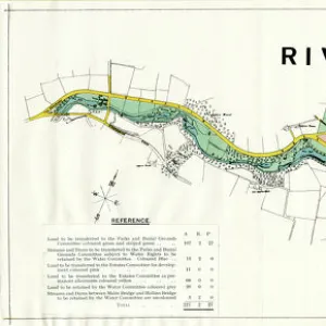
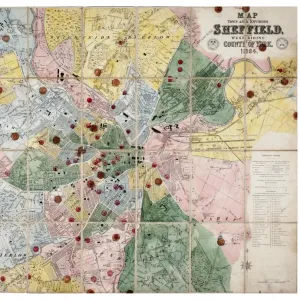
Framed Print : Contoured plan of Rivelin Valley Road, Sheffield, Yorkshire, c. 1900


![]()
Framed Photos from Sheffield City Archives
Contoured plan of Rivelin Valley Road, Sheffield, Yorkshire, c. 1900
Full title: Contoured plan of Rivelin Valley Road shewing land belonging to the Sheffield Water Department, c. 1900
From an original at Sheffield Libraries: arc02953
Scale 25 inches : 1 mile.
Surveyor: L. M. S. Marsh, Water Engineer.
Lithographers: Pawson and Brailsford.
The line edged pink belongs to the Sheffield Water Department and is available for laying out in building sites, etc. That coloured blue [actually green on the map?] belongs to the Water Department but is only available for recreation grounds and similar purposes.
From Rivelin Mill Bridge in the west to Holme Lane Bridge in the east.
Reading left to right:
Rivelin Mill Bridge
Mill Dam
Rivelin mills
Rails Road
Upper Coppice Wheel
Lower Coppice Wheel
Rivelin Wire Mill
The Coppice
Coppice Farm
Manchester Road
Coppice Wood
Rivelin Glen
Low Coppice House
Paper mill
Coppice House
Wolf Wheel
Tofts Lane
oak Farm
Under Tofts
Rivelin Hotel
Hagg Lane Cottages
Iron Wheel
Glen House
Glen Bridge
Upper Cut Wheel
Den Bank Plantation
Hagg Lane
New Wheel
Little London Wheel
Liberty Hill
Holme Head Wheel
Allotment gardens
Russel Wood
Roscoe Plantation
Roscoe Wheel
Roscoe Bridge
The Hagg
Haggs House
Reaps Wood
Back Lane
Spooners Wheels
Bole Hill Road
Staney Wood
Hollins Bridge Mill
Holly Bush Inn
St Michaels Mortuary Chapel / Roman Catholic Cemetery
Hollins Bridge
Rivelin Road
Walkley Bank Tilt
Mouse Hole Forge
Walkley Bank
Morley Street
Holme Lane Bridge
Malin Bridge
Part of Holme Lane
Part of Loxley New Road
Sheffield City Archives and Local Studies Library has an unrivalled collection of images of Sheffield, England
Media ID 19042530
© Sheffield City Council
A1 Premium Frame with A2 Poster
Discover the rich history of Sheffield with our stunning Framed Print of the Contoured plan of Rivelin Valley Road, dating back to circa 1900. This exquisite piece, taken from the Sheffield City Archives (arc02953), showcases the intricate details of the Sheffield Water Department's land along Rivelin Valley Road. The contoured plan, produced by OS14000_A0 #57863, provides a fascinating glimpse into the past, making it a perfect addition to any home or office. Bring history to life with our Framed Prints, expertly crafted to preserve and protect your chosen image for years to come.
Premium Paradise Wooden Range A1 Premium Poster Frame (86x62cm) with A2 Poster (59x42cm) and mounted behind a white matt board to make your photo really stand out. FSC Certified and Rainforest Alliance Certified for environmental, social, and economic sustainably. High transparency tempered glass window with a smooth finished frame. Great for filling empty walls, decorating blank spaces, or creating eye-catching gallery walls. Frames arrive ready to hang. Sent with secure, protective packaging. Smooth wooden veneer mimics the real wood look and feel with ultra-durable scratch resistance tempered glass.
Contemporary Framed and Mounted Prints - Professionally Made and Ready to Hang
Estimated Image Size (if not cropped) is 57.8cm x 57.8cm (22.8" x 22.8")
Estimated Product Size is 86.6cm x 62cm (34.1" x 24.4")
These are individually made so all sizes are approximate
Artwork printed orientated as per the preview above, with landscape (horizontal) or portrait (vertical) orientation to match the source image.
FEATURES IN THESE COLLECTIONS
> Animals
> Insects
> Hemiptera
> Green Scale
> Animals
> Insects
> Hemiptera
> Holly Scale
> Animals
> Mammals
> Muridae
> Little Wood Mouse
> Arts
> Artists
> R
> Roman Roman
> Europe
> France
> Canton
> Landes
> Europe
> United Kingdom
> England
> London
> Towns
> Mill Hill
> Europe
> United Kingdom
> England
> London
> Towns
> West Green
> Europe
> United Kingdom
> England
> London
> Towns
> West Hill
> Europe
> United Kingdom
> England
> London
> Towns
> Wood Green
> Sheffield City Archives
> Maps and Plans
> Maps of Sheffield
EDITORS COMMENTS
This vintage print showcases a contoured plan of Rivelin Valley Road in Sheffield, Yorkshire, dating back to around 1900. The detailed map, titled "Contoured plan of Rivelin Valley Road shewing land belonging to the Sheffield Water Department" provides valuable insight into the city's historical development and infrastructure. Created by surveyor L. M. S. Marsh, who served as the Water Engineer at that time, this map was skillfully lithographed by Pawson and Brailsford. It features a scale of 25 inches to 1 mile, allowing for precise measurements and accurate representation. The pink line on the map indicates land owned by the Sheffield Water Department that is available for potential building sites or other purposes. In contrast, areas colored blue (though appearing green on the map) are designated solely for recreational grounds and similar uses. Spanning from Rivelin Mill Bridge in the west to Holme Lane Bridge in the east, this comprehensive plan highlights various landmarks along Rivelin Valley Road such as mills, bridges, farms, cottages, wheels (used in manufacturing processes), plantations, allotment gardens, and even religious structures like St Michaels Mortuary Chapel/Roman Catholic Cemetery. Preserved within Sheffield Libraries' archives under reference arc02953 from an original source material held at Sheffield City Archives itself (#57863), this print offers a fascinating glimpse into both urban planning history and local water management practices during that era in Yorkshire's vibrant cityscape.
MADE IN AUSTRALIA
Safe Shipping with 30 Day Money Back Guarantee
FREE PERSONALISATION*
We are proud to offer a range of customisation features including Personalised Captions, Color Filters and Picture Zoom Tools
SECURE PAYMENTS
We happily accept a wide range of payment options so you can pay for the things you need in the way that is most convenient for you
* Options may vary by product and licensing agreement. Zoomed Pictures can be adjusted in the Cart.