Framed Print > Animals > Insects > Hemiptera > Hall Scale
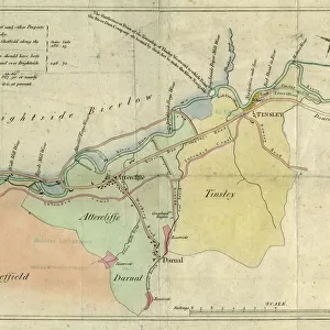
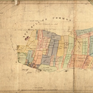
Framed Print : Plan of Carbrook Hall Estate, in the townships of Attercliffe cum Darnall and Tinsley, 1852


![]()
Framed Photos from Sheffield City Archives
Plan of Carbrook Hall Estate, in the townships of Attercliffe cum Darnall and Tinsley, 1852
Scale 1 inch : 3 chains.C. Bartholomew, Rotherham.Martin and Hood, Lithographers, LondonFull details of each lot are given in the sale particulars.Original at Sheffield Local Studies Library: Sale Plans 21 December 1852
Sheffield City Archives and Local Studies Library has an unrivalled collection of images of Sheffield, England
Media ID 14050796
© Sheffield City Council
Attercliffe Brightside Carbrook Hall Maps Plans Tinsley
13.5"x11.5" (34x29cm) Premium Frame
Step back in time with our stunning Framed Print from Media Storehouse's historical collection. This exquisite piece features an 1852 Plan of Carbrook Hall Estate, meticulously detailed and originally sourced from Sheffield City Archives. The Plan, which covers the townships of Attercliffe cum Darnall and Tinsley, was produced by renowned surveyors C. Bartholomew of Rotherham, and lithographers Martin and Hood of London. The intricate lines and precise details bring history to life, making this a perfect addition to any home or office. Each Framed Print comes with full details of the lot from the original sale particulars and is a true piece of Sheffield's rich history. Original at Sheffield Local Studies Library.
Framed and mounted 9x7 print. Professionally handmade full timber moulded frames are finished off with framers tape and come with a hanging solution on the back. Outer dimensions are 13.5x11.5 inches (34x29cm). Quality timber frame frame moulding (20mm wide and 30mm deep) with frame colours in your choice of black, white, or raw oak and a choice of black or white card mounts. Frames have a perspex front providing a virtually unbreakable glass-like finish which is easily cleaned with a damp cloth.
Contemporary Framed and Mounted Prints - Professionally Made and Ready to Hang
Estimated Image Size (if not cropped) is 21.4cm x 21.4cm (8.4" x 8.4")
Estimated Product Size is 29.2cm x 34cm (11.5" x 13.4")
These are individually made so all sizes are approximate
Artwork printed orientated as per the preview above, with landscape (horizontal) or portrait (vertical) orientation to match the source image.
FEATURES IN THESE COLLECTIONS
> Animals
> Insects
> Hemiptera
> Hall Scale
> Maps and Charts
> Related Images
> Sheffield City Archives
> Maps and Plans
EDITORS COMMENTS
This print showcases the intricate "Plan of Carbrook Hall Estate" from 1852, providing a fascinating glimpse into the townships of Attercliffe cum Darnall and Tinsley. Created by C. Bartholomew in Rotherham and skillfully lithographed by Martin and Hood in London, this detailed map offers a scale of 1 inch to 3 chains. The historical significance of this document is evident as it reveals the layout and boundaries of Carbrook Hall Estate during a pivotal era. The estate's rich history unfolds through its depiction on this plan, which was originally housed at Sheffield Local Studies Library under Sale Plans dated December 21st, 1852. While we are unable to delve into specific commercial details due to restrictions outlined by Sheffield City Archives, this print allows us to appreciate the craftsmanship involved in creating such an intricate map. Every lot within the estate is meticulously highlighted with full details provided in the accompanying sale particulars. Brightside residents will undoubtedly find delight in exploring their local area's past through this visual representation. Maps and plans enthusiasts alike will be captivated by the level of detail presented here, showcasing how land was divided during that period. Preserved for generations to come at Sheffield Local Studies Library, this remarkable print serves as a valuable resource for historians, researchers, or anyone curious about uncovering our city's vibrant heritage.
MADE IN AUSTRALIA
Safe Shipping with 30 Day Money Back Guarantee
FREE PERSONALISATION*
We are proud to offer a range of customisation features including Personalised Captions, Color Filters and Picture Zoom Tools
SECURE PAYMENTS
We happily accept a wide range of payment options so you can pay for the things you need in the way that is most convenient for you
* Options may vary by product and licensing agreement. Zoomed Pictures can be adjusted in the Cart.


![A map of the lands near Attercliffe and Darnall, [?1820s]](/sq/716/map-lands-near-attercliffe-darnall-1820s-18396317.jpg.webp)