Framed Print > Sheffield City Archives > Maps and Plans
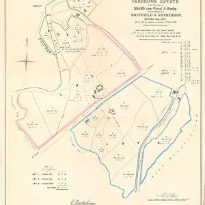
Framed Print : Plan of an Estate situate at Grimesthorpe belonging to Robert White esquire, 1866


![]()
Framed Photos from Sheffield City Archives
Plan of an Estate situate at Grimesthorpe belonging to Robert White esquire, 1866
Scale: 1.5 inches: 100 feet.Surveyor: S. F. Holmes.Original at Sheffield Local Studiess (5) 2 L
Sheffield City Archives and Local Studies Library has an unrivalled collection of images of Sheffield, England
Media ID 14049259
© Sheffield City Council
Brightside Grimesthorpe Lane Maps Road Street Bland Botham Carlisle Clifton Donald Draper Knowsley Lincoln Lynton Petre Ruthin Sharp
13.5"x11.5" (34x29cm) Premium Frame
Step back in time with our exquisite Framed Print from Media Storehouse. This stunning antique map depicts a meticulously detailed Plan of an Estate situated at Grimesthorpe, owned by Robert White, Esquire, in 1866. Surveying expertise was provided by S.F. Holmes. Gaze upon the intricacies of this historical document, now beautifully framed and ready to add character to your home or office. Original held at Sheffield Local Studies (5) 2 L. Scale: 1.5 inches : 100 feet. A captivating addition to your collection, this Framed Print is not just a decorative piece, but a window into history.
Framed and mounted 9x7 print. Professionally handmade full timber moulded frames are finished off with framers tape and come with a hanging solution on the back. Outer dimensions are 13.5x11.5 inches (34x29cm). Quality timber frame frame moulding (20mm wide and 30mm deep) with frame colours in your choice of black, white, or raw oak and a choice of black or white card mounts. Frames have a perspex front providing a virtually unbreakable glass-like finish which is easily cleaned with a damp cloth.
Contemporary Framed and Mounted Prints - Professionally Made and Ready to Hang
Estimated Image Size (if not cropped) is 21.4cm x 21.4cm (8.4" x 8.4")
Estimated Product Size is 34cm x 29.2cm (13.4" x 11.5")
These are individually made so all sizes are approximate
Artwork printed orientated as per the preview above, with landscape (horizontal) or portrait (vertical) orientation to match the source image.
EDITORS COMMENTS
This print showcases the detailed "Plan of an Estate situate at Grimesthorpe" in 1866, which belonged to the esteemed Robert White, Esquire. The scale of this plan is meticulously measured at 1.5 inches to represent every 100 feet of the estate's sprawling grounds. The skilled surveyor behind this masterpiece was none other than S. F. Holmes. Preserved within Sheffield Local Studies (5) 2 L, this historical document provides a fascinating glimpse into the past and offers valuable insights into the layout and structure of Grimesthorpe during that era. The map encompasses various streets such as Brightside, Sharp, Petre, Cockshutts Lane, Botham Carlisle Road, Hunsley Moss Bland Draper Clifton Adsetts Lincoln Place Lynton Donald Ruthin Knowsley. While admiring this exceptional print from Sheffield City Archives (please note that it is not associated with any commercial use), one can appreciate its significance in understanding the development and evolution of Grimesthorpe over time. It serves as a testament to both Robert White's ownership and his commitment to meticulous planning. With each intricate detail captured on paper by S. F. Holmes' expert handiwork, this photograph allows us to step back in time and immerse ourselves in the rich history surrounding Grimesthorpe estate.
MADE IN AUSTRALIA
Safe Shipping with 30 Day Money Back Guarantee
FREE PERSONALISATION*
We are proud to offer a range of customisation features including Personalised Captions, Color Filters and Picture Zoom Tools
SECURE PAYMENTS
We happily accept a wide range of payment options so you can pay for the things you need in the way that is most convenient for you
* Options may vary by product and licensing agreement. Zoomed Pictures can be adjusted in the Cart.


![The Duke of Norfolks estates in Brightside Bierlow, Sheffield, [mid 19th cent]](/sq/716/duke-norfolks-estates-brightside-bierlow-20355002.jpg.webp)