Fraud Blocker Skip to main content

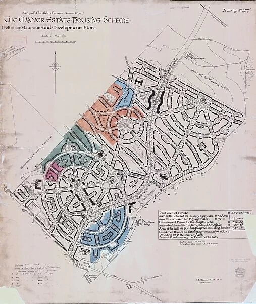
Preliminary layout and development plan of the Manor Estate Housing Scheme, 1924

Preliminary layout and development plan of the Manor Estate Housing Scheme, 1924
Sold 1
In Stock
We accept all major payment options so you can pay for the things you need in the way that is most convenient for you
Framed Photos
Buy from AU$119.99
Photo Prints
Buy from AU$12.99
Jigsaw Puzzles
Buy from AU$89.99
Poster Prints
Buy from AU$24.99
Canvas Prints
Buy from AU$124.99
Fine Art Prints
Buy from AU$92.53
Metal Prints
Buy from AU$43.99
Cards
Buy from AU$12.99
Home Decor
Buy from AU$24.99

Sheffield City Archives Photo Prints and Wall Art

Preliminary layout and development plan of the Manor Estate Housing Scheme, 1924

Sheffield City Council, Estates Committee.Original dimensions: 93 x 79 cm.Sheffield Local Studies Library:s (13) 4 L. Sheffield City Archives and Local Studies Library has an unrivalled collection of images of Sheffield, England. © Sheffield City Council

Media ID 14051848

Avenue Cemeteries Cemetery City Coal Collieries Crescent Farm House Housing Industry Lane Manor Maps Norfolk Park Plans Primary Queen Road School Schools Sheffield Street Wood Archdale Babington Beaumont Bowden Cary Colliery Council Crabtree Desmond Estate Fairfax Fold Harborough Leonard Navan Scotia Windy Woodthorpe

SECURE PAYMENTS
We accept all major payment options so you can pay for the things you need in the way that is most convenient for you

Made in Australia
Safe Shipping, Easy Returns

FREE PERSONALISATION
We are proud to offer a range of customisation including Cropping, Captions, and Filters. Zoom Cropping can be adjusted in the basket


EDITORS COMMENTS

This print showcases the preliminary layout and development plan of the Manor Estate Housing Scheme in Sheffield, dating back to 1924. The photograph, preserved by the Sheffield City Council's Estates Committee, offers a glimpse into the meticulous planning that went into creating this residential haven. With original dimensions of 93 x 79 cm, it is an invaluable piece housed in the Sheffield Local Studies Library. The intricate map reveals a network of roads and streets that intertwine throughout the estate. Prince Wales Road stands proudly as one of its main arteries, while Wulfric Windy House Lane meanders through charming corners. Fretson Harborough Avenue leads residents towards Norfolk Park Primary School and other educational institutions nearby. Notably, this housing scheme pays homage to Sheffield's coal industry heritage with references to Woodthorpe Colliery and other collieries scattered across the area. Additionally, Crabtree Farm adds a touch of rural charm amidst urban landscapes. As we explore further on this visual journey, names like Cary Travey Navan Fitzhubert catch our attention alongside Queen Mary Motehill and Noehill Bowden Housteads Woodlands Riddings Close Pipworth Beaumont Ravencarr Frecheville Waltheof Hastilar Archdale Bassledene Cullabine Leonard Desmond Crescent Fairfax Fold Babington Scotia. This historical gem from Sheffield City Archives reminds us of the city's rich past while offering insights into its visionary urban planning efforts for future generations to enjoy.


Framed Prints of Preliminary layout and development plan of the Manor Estate Housing Scheme, 1924

Step back in time with our exclusive Framed Print from Media Storehouse, featuring the Preliminary layout and development plan of the Manor Estate Housing Scheme from 1924. This historic document, originally from Sheffield City Archives, provides a fascinating insight into the early planning stages of this significant housing development. Display this beautifully preserved piece in your home or office to add a touch of timeless charm and historical significance to your space. Each Framed Print is meticulously crafted with museum-quality materials to ensure long-lasting durability and vibrant color representation. Order yours today and bring a piece of Sheffield's history into your home.


Photo Prints of Preliminary layout and development plan of the Manor Estate Housing Scheme, 1924

Experience a piece of Sheffield's history with our exclusive Media Storehouse Photographic Print of the Preliminary layout and development plan of the Manor Estate Housing Scheme from 1924. This historic image, sourced from Sheffield City Archives, provides a fascinating glimpse into the planning stages of one of the city's most significant housing developments. Bring this captivating piece of local history into your home or office and add character to any space. Order your Media Storehouse Photographic Print today and relive the past.


Poster Prints of Preliminary layout and development plan of the Manor Estate Housing Scheme, 1924

"Step back in time with our exquisite selection of historic poster prints from the Media Storehouse. This particular piece showcases an intriguing preliminary layout and development plan of the Manor Estate Housing Scheme from 1924, sourced from the Sheffield City Archives. With meticulous attention to detail and authenticity, this print transports you back to an era of architectural innovation and urban planning. A captivating addition to any home or office space, this vintage print not only serves as a beautiful decorative piece but also as a testament to the rich history of Sheffield's urban development. Order yours today and bring a piece of the past into your present."


Jigsaw Puzzles of Preliminary layout and development plan of the Manor Estate Housing Scheme, 1924

Discover the history of Sheffield's architectural past with the Media Storehouse Jigsaw Puzzle featuring the Preliminary Layout and Development Plan of the Manor Estate Housing Scheme from 1924. This intriguing puzzle showcases an original plan from the Sheffield City Archives, offering a unique glimpse into the urban planning of the time. Piece together this captivating jigsaw and transport yourself back to the early 20th century as you uncover the intricate details of this historic document. A perfect activity for history enthusiasts, families, and puzzle lovers alike.

diamond
Made With High Grade Materials
thumb_up
Professional Quality Finish
package_2
Carefully Packed To Aid Safe Arrival

You May Also Like


Map of the Town and Environs of Sheffield, 1864Map of the Town and Environs of Sheffield, 1864
Add to Basket
City of Sheffield Central Planning Scheme, Historical Growth, 1938City of Sheffield Central Planning Scheme, Historical Growth, 1938
Add to Basket
North Sheffield marked with bombing targets, c. 1940North Sheffield marked with bombing targets, c. 1940
Add to Basket
Plan of Sheffield, 19th centPlan of Sheffield, 19th cent
Add to Basket
A correct plan of the town of Sheffield by William Fairbank, 1771A correct plan of the town of Sheffield by William Fairbank, 1771
Add to Basket
Ordnance Survey map of north east Sheffield copied by the Germans, and marked with bombing targets, c. 1940Ordnance Survey map of north east Sheffield copied by the Germans, and marked with bombing targets, c. 1940
Add to Basket
Plan of Sheffield by Pawson and BrailsfordPlan of Sheffield by Pawson and Brailsford
Add to Basket
Map of the Rivelin Valley Estate, 1934Map of the Rivelin Valley Estate, 1934
Add to Basket
Plan of the Meersbrook Bank Estate near Sheffield, 1876Plan of the Meersbrook Bank Estate near Sheffield, 1876
Add to Basket
Sheffield Manor House, off Manor Lane, SheffieldSheffield Manor House, off Manor Lane, Sheffield
Add to Basket
Norton from the survey of W and J Fairbank, 1804Norton from the survey of W and J Fairbank, 1804
Add to Basket
Plan of Sheffield, 1838Plan of Sheffield, 1838
Add to Basket

Gallery Wall Inspiration

A new map of Yorkshire, divided into its ridings and wapentakes, exhibiting its roads, rivers, parks, etc. John Cary, 1810
A Plan of the town of Sheffield in the county of York drawn by W. Fairbank 1797. Engraved by Thomas Harris
Plan of Hillsborough Park, 1897
A plan of the intended canal from Sheffield to Tinsley by W. and J. Fairbank, 1815
Map of the parish of Sheffield by W. Fairbank and Son (engraved by J. Cary), 1795
Map of the Rivelin Valley Estate, 1934
South Yorkshire Coalfield, c. 1925
Plan of Navigable Rivers and Canals connected with the Aire and Calder Navigation; with a Proposed Canal from Knottingley to Goole, 1818
Proposed mode of laying out for building purposes the Sharrow and Kenwood Park Estates near Sheffield belonging to George Wostenholm, 1853
Plan of Endcliffe Park, 1897
Ordnance Survey map of north Sheffield copied by the Germans, and marked with bombing targets
Plan of the Meersbrook Bank Estate near Sheffield, 1876
Plan of The Crown and Glove Public house and other land and property at Stannington, for sale
Plan of Sheffield c. 1880
Sale plan for the Endcliffe Grange Estate, Endcliffe Vale Road, 1867
A map of Attercliffe Forge and the Farm, Tenements etc annxed thereto... belonging to the Duke of Norfolk and... Eliz Fell, 1768
Map of Sheffield
Street map of Nether Hallam
Plan of lands at Neepsend by The Sheffield Gas Company, 1929
Sheffield United Football Club, Bramall Lane, Sheffield - proposed new terracing, 1901
South Yorkshire Asylum - also referred to as Wadsley Asylum later Middlewood Hospital - plan of estate
Preliminary layout and development plan of the Manor Estate Housing Scheme, 1924
Sheffield (Central) Planning Scheme; Draft Scheme Map, 1939
Plan of Lydgate Hall Estate as allotted for sale, 1860
Plan of part of the Town of Sheffield shewing the existing markets, the property of His Grace the Duke of Norfolk, and the Projected improvements, 1847
Ordnance Survey map of north east Sheffield copied by the Germans, and marked with bombing targets, c. 1940
Ordnance Survey map: Totley, 1876


© Copyright Media Storehouse, All Rights Reserved 2003 - 2024
Facebook     Pinterest     100% Payment Secure     Reviews IO