Framed Print > Animals > Fishes > R > Red Grouper
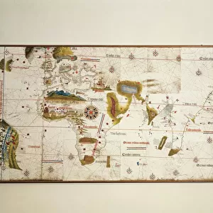
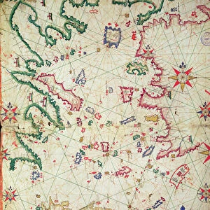
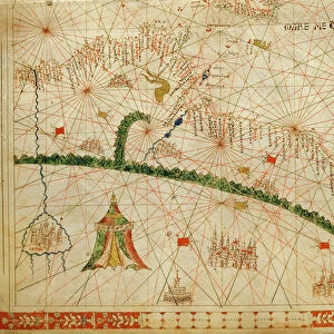
Framed Print : Map attributed to Paolo dal Pozzo Toscanelli, 1397-1482


![]()
Framed Photos from Universal Images Group (UIG)
Map attributed to Paolo dal Pozzo Toscanelli, 1397-1482
Cartography, Italy, 15th century. Map attributed to Paolo dal Pozzo Toscanelli (1397-1482)
Universal Images Group (UIG) manages distribution for many leading specialist agencies worldwide
Media ID 9570625
© DEA / PINAIDER
A2 Premium Frame with A3 Poster
Discover the rich history of cartography with our stunning Framed Prints from Media Storehouse. This exquisite piece showcases a map attributed to the renowned Italian cartographer, Paolo dal Pozzo Toscanelli (1397-1482). Dating back to the 15th century, this captivating map from Universal Images Group (UIG) adds an air of sophistication and intrigue to any room. With meticulous attention to detail, our framing enhances the beauty of this historical treasure, making it a perfect addition to your home or office decor. Bring the past to life with this beautiful and authentic work of art.
Premium Paradise Wooden Range A2 Premium Poster Frame (62x45cm) with A3 Poster (42x30cm) and mounted behind a white matt board to make your photo really stand out. FSC Certified and Rainforest Alliance Certified for environmental, social, and economic sustainably. High transparency tempered glass window with a smooth finished frame. Great for filling empty walls, decorating blank spaces, or creating eye-catching gallery walls. Frames arrive ready to hang. Sent with secure, protective packaging. Smooth wooden veneer mimics the real wood look and feel with ultra-durable scratch resistance tempered glass.
Contemporary Framed and Mounted Prints - Professionally Made and Ready to Hang
Estimated Image Size (if not cropped) is 40.4cm x 40.4cm (15.9" x 15.9")
Estimated Product Size is 62cm x 44.6cm (24.4" x 17.6")
These are individually made so all sizes are approximate
Artwork printed orientated as per the preview above, with landscape (horizontal) or portrait (vertical) orientation to match the source image.
FEATURES IN THESE COLLECTIONS
> Animals
> Fishes
> R
> Red Grouper
> Europe
> Italy
> Related Images
> Maps and Charts
> Italy
> Maps and Charts
> Related Images
> Universal Images Group (UIG)
> Art
> Painting, Sculpture & Prints
> Cartography
EDITORS COMMENTS
This print showcases a remarkable piece of history - a map attributed to the renowned Italian cartographer, Paolo dal Pozzo Toscanelli. Created in the 15th century, this exquisite work of art offers a glimpse into the world of early cartography and Italy's rich geographical landscape. The map is beautifully presented with its vibrant red hue dominating the horizontal composition. Its intricate details and topographical accuracy are testaments to Toscanelli's expertise in his craft. The elliptical shape adds an element of uniqueness, setting it apart from conventional maps. As we delve into this masterpiece, we are transported back in time, imagining how travelers and explorers relied on such maps for navigation during an era when technology was limited. It serves as a reminder of human curiosity and our innate desire to explore uncharted territories. While devoid of people, this photograph allows us to appreciate the sheer beauty and artistic merit behind Toscanelli's creation. Every stroke and line on this illustration-turned-painting tells a story about Italy's past - its cities, rivers, mountains, and coastlines that have shaped its identity throughout centuries. This print from Universal Images Group (UIG) provides us with an opportunity to admire one man's contribution to cartography while also appreciating the historical significance embedded within this ancient artifact. Let it serve as a visual testament to humanity's quest for knowledge and understanding through artistry.
MADE IN AUSTRALIA
Safe Shipping with 30 Day Money Back Guarantee
FREE PERSONALISATION*
We are proud to offer a range of customisation features including Personalised Captions, Color Filters and Picture Zoom Tools
SECURE PAYMENTS
We happily accept a wide range of payment options so you can pay for the things you need in the way that is most convenient for you
* Options may vary by product and licensing agreement. Zoomed Pictures can be adjusted in the Cart.