Framed Print > Europe > United Kingdom > Scotland > Highlands > Alness
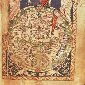
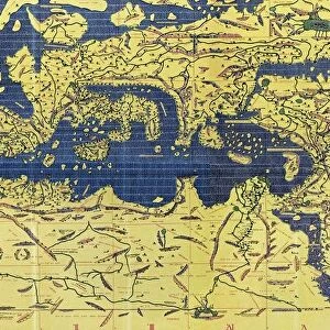
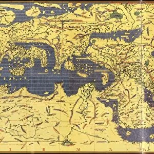
Framed Print : Copy made in Cairo in 1456 of the world map prepared by the Arab geographer Muhammad al-Idrisi


![]()
Framed Photos from Universal Images Group (UIG)
Copy made in Cairo in 1456 of the world map prepared by the Arab geographer Muhammad al-Idrisi
Copy made in Cairo in 1456 of the world map prepared by the Arab geographer Muhammad al-Idrisi (1100-1165) for Roger II (1095-1154) King of Sicily from 1130. In this map, North is at the bottom
Universal Images Group (UIG) manages distribution for many leading specialist agencies worldwide
Media ID 9756859
© Universal History Archive/Universal Images Group
12th Arab Bottom Cairo Century Commerce Copy Geographer King Muhammad North Prepared Roger Sicily Trade Twelfth 1130 1456 Al Idrisi
13.5"x11.5" (34x29cm) Premium Frame
Introducing the Media Storehouse Framed Print of the ancient world map, a captivating masterpiece created in Cairo in 1456. This exquisite print showcases the intricate work of the renowned Arab geographer Muhammad al-Idrisi, meticulously crafted for King Roger II of Sicily. With North depicted at the bottom, this map represents a fascinating glimpse into the cartography of the medieval world. Let this beautiful piece transport you back in time and add a touch of history to your space.
Framed and mounted 9x7 print. Professionally handmade full timber moulded frames are finished off with framers tape and come with a hanging solution on the back. Outer dimensions are 13.5x11.5 inches (34x29cm). Quality timber frame frame moulding (20mm wide and 30mm deep) with frame colours in your choice of black, white, or raw oak and a choice of black or white card mounts. Frames have a perspex front providing a virtually unbreakable glass-like finish which is easily cleaned with a damp cloth.
Contemporary Framed and Mounted Prints - Professionally Made and Ready to Hang
Estimated Image Size (if not cropped) is 21.4cm x 21.4cm (8.4" x 8.4")
Estimated Product Size is 29.2cm x 34cm (11.5" x 13.4")
These are individually made so all sizes are approximate
Artwork printed orientated as per the preview above, with landscape (horizontal) or portrait (vertical) orientation to match the source image.
FEATURES IN THESE COLLECTIONS
> Europe
> Italy
> Sicily
> Related Images
> Europe
> United Kingdom
> Scotland
> Highlands
> Alness
> Maps and Charts
> Related Images
> Maps and Charts
> World
> Universal Images Group (UIG)
> History
EDITORS COMMENTS
This print showcases a remarkable piece of history - a copy made in Cairo in 1456 of the world map prepared by the esteemed Arab geographer Muhammad al-Idrisi for Roger II, the King of Sicily during the 12th century. In this intricate map, an intriguing twist awaits as North is depicted at the bottom rather than its conventional position at the top. The significance of this map lies not only in its stunning cartography but also in its representation of a pivotal era marked by exploration and trade. It serves as a testament to the flourishing commerce and cultural exchange that characterized this period between different regions across the globe. Muhammad al-Idrisi's meticulous craftsmanship and geographical knowledge are evident through his detailed depiction of various lands, seas, and continents. This masterpiece provides invaluable insights into how people perceived and understood our world centuries ago. As we delve into this image, we are transported back to Cairo in 1456 when skilled artisans worked diligently to reproduce al-Idrisi's original creation for future generations to admire. The delicate lines and vibrant colors bring life to each corner of this ancient map, inviting us on an imaginary journey through time. Let us marvel at this extraordinary artifact that bridges cultures, connects historical figures like Roger II with Muhammad al-Idrisi, and reminds us of humanity's ceaseless quest for knowledge about our planet.
MADE IN AUSTRALIA
Safe Shipping with 30 Day Money Back Guarantee
FREE PERSONALISATION*
We are proud to offer a range of customisation features including Personalised Captions, Color Filters and Picture Zoom Tools
SECURE PAYMENTS
We happily accept a wide range of payment options so you can pay for the things you need in the way that is most convenient for you
* Options may vary by product and licensing agreement. Zoomed Pictures can be adjusted in the Cart.