Fraud Blocker Skip to main content

Compass Rose Collection

"Exploring the World through Compass Rose

Background imageCompass Rose Collection: VIRGINIA MAP, 1612. Captain John Smiths map of Virginia, 1612

VIRGINIA MAP, 1612. Captain John Smiths map of Virginia, 1612

Background imageCompass Rose Collection: Map of Sicily region, by Joan Blaeu

Map of Sicily region, by Joan Blaeu
Cartography, Italy, 17th century. Map of Sicily region, by Joan Blaeu

Background imageCompass Rose Collection: Map of Eden and Mount Ararat, copperplate engraving, published 1774

Map of Eden and Mount Ararat, copperplate engraving, published 1774
A Map of the Situation of the Garden of Eden as also of Mount Ararat whereon the Ark rested. Copperplate engraving, published in 1774

Background imageCompass Rose Collection: cartography, compass rose, indian ocean, map, melanesia, mercator projection

cartography, compass rose, indian ocean, map, melanesia, mercator projection, micronesia, new zealand, no people, oceania, pacific ocean, political map, polynesia, tropic of capricorn, australia

Background imageCompass Rose Collection: Atlas compass, 16th century

Atlas compass, 16th century
Atlas compass in a 1544 copy of the Agnese Atlas. Several copies of this atlas were produced between 1536 and 1564, in Venice, by the Italian mapmaker Battista Agnese

Background imageCompass Rose Collection: Map of India and Indian Ocean, from Miller Atlas by Pedro and Jorge Reinel, Lopo Homen

Map of India and Indian Ocean, from Miller Atlas by Pedro and Jorge Reinel, Lopo Homen
Cartography, 16th century. Map of India and Indian Ocean, from Miller Atlas, by Pedro and Jorge Reinel, Lopo Homen (cartographers) and Antonio de Holanda (miniaturist), 1519

Background imageCompass Rose Collection: A compass rose showing the cardinal points

A compass rose showing the cardinal points
5310230 A compass rose showing the cardinal points; (add.info.: Woodblock engraving depicting a compass rose showing the cardinal points)

Background imageCompass Rose Collection: Analematic sundial (by projecting the shadow of the gnomon) for latitude 51 degrees

Analematic sundial (by projecting the shadow of the gnomon) for latitude 51 degrees, c.1697 (copper and steel)
MMM5469097 Analematic sundial (by projecting the shadow of the gnomon) for latitude 51 degrees, c.1697 (copper and steel); National Maritime Museum, London

Background imageCompass Rose Collection: Plan of Memel (present-day Klaipeda, Lithuania), during the surrender of the city

Plan of Memel (present-day Klaipeda, Lithuania), during the surrender of the city, 27 June to 5 July 1757
MMM5482024 Plan of Memel (present-day Klaipeda, Lithuania), during the surrender of the city, 27 June to 5 July 1757. Etching water in 1764 colors.; National Maritime Museum, London

Background imageCompass Rose Collection: Astronomical compendium for unknown latitude, 17th century (brass)

Astronomical compendium for unknown latitude, 17th century (brass)
MMM5475258 Astronomical compendium for unknown latitude, 17th century (brass); National Maritime Museum, London, UK; (add.info.: Astronomical compendium for unknown latitude)

Background imageCompass Rose Collection: Portable horizontal sundial with magnetic compass Silver and ivory instrument

Portable horizontal sundial with magnetic compass Silver and ivory instrument, c.1650-1700 (silver and ivory)
MMM5474404 Portable horizontal sundial with magnetic compass Silver and ivory instrument, c.1650-1700 (silver and ivory); National Maritime Museum, London

Background imageCompass Rose Collection: Butterfield sundial Brass instrument, late 17th century, by Chapotot (?) (brass)

Butterfield sundial Brass instrument, late 17th century, by Chapotot (?) (brass)
MMM5473359 Butterfield sundial Brass instrument, late 17th century, by Chapotot (?) (brass); National Maritime Museum, London, UK; (add.info.: Butterfield sundial Brass instrument, late 17th century)

Background imageCompass Rose Collection: 19th Century Windrose compass with 32-dash subvision

19th Century Windrose compass with 32-dash subvision
3078434 19th Century Windrose compass with 32-dash subvision; (add.info.: 19th Century Windrose compass with 32-dash subvision. Dated 19th Century.); Universal History Archive/UIG.

Background imageCompass Rose Collection: Atlantic coasts of Europe, Norway to Finisterre, 1666 (vellum)

Atlantic coasts of Europe, Norway to Finisterre, 1666 (vellum)
7340461 Atlantic coasts of Europe, Norway to Finisterre, 1666 (vellum) by Comberford, Nicholas (d.1673); 79x27 cm; National Maritime Museum, London

Background imageCompass Rose Collection: The battle off the Isle of Wight on 4 August, 1588, c.1590 (coloured engraving)

The battle off the Isle of Wight on 4 August, 1588, c.1590 (coloured engraving)
7340031 The battle off the Isle of Wight on 4 August, 1588, c.1590 (coloured engraving) by Adams, Robert (1540-95) (after); 38x50 cm; National Maritime Museum, London

Background imageCompass Rose Collection: Map of the journey of the Israelites, since their exit from Egypt, 1739 (engraving)

Map of the journey of the Israelites, since their exit from Egypt, 1739 (engraving)
8822197 Map of the journey of the Israelites, since their exit from Egypt, 1739 (engraving); Private Collection; (add.info)

Background imageCompass Rose Collection: Latitude 49 degree sundial and magnetic compass, with lid, 17th century (copper and ivory)

Latitude 49 degree sundial and magnetic compass, with lid, 17th century (copper and ivory)
MMM5470060 Latitude 49 degree sundial and magnetic compass, with lid, 17th century (copper and ivory); National Maritime Museum, London

Background imageCompass Rose Collection: Sundial with lid, with gnomon mounted on the circle of hours, c.1700 (brass)

Sundial with lid, with gnomon mounted on the circle of hours, c.1700 (brass)
MMM5475190 Sundial with lid, with gnomon mounted on the circle of hours, c.1700 (brass); National Maritime Museum, London, UK; (add.info.: Sundial with lid)

Background imageCompass Rose Collection: 'Rhodes and Symi (Greek islands) facing the Turkish coast

'Rhodes and Symi (Greek islands) facing the Turkish coast
MMM5474179 'Rhodes and Symi (Greek islands) facing the Turkish coast; National Maritime Museum, London, UK; (add.info.: Rhodes and Symi (Greek islands) facing the Turkish coast

Background imageCompass Rose Collection: The solar system.Theory of the seasons. 1865 (engraving)

The solar system.Theory of the seasons. 1865 (engraving)
8766902 The solar system.Theory of the seasons. 1865 (engraving); Private Collection; (add.info.: The solar system.Theory of the seasons.Engraved by J)

Background imageCompass Rose Collection: Plan of the Battle of Copenhagen (Denmark) (1801)

Plan of the Battle of Copenhagen (Denmark) (1801)
MMM5484862 Plan of the Battle of Copenhagen (Denmark) (1801); National Maritime Museum, London, UK; (add.info.: Plan of the Battle of Copenhagen (Denmark) (1801)

Background imageCompass Rose Collection: Atlantic Ocean, 5 degrees south to 57 degrees north, 1650 (vellum)

Atlantic Ocean, 5 degrees south to 57 degrees north, 1650 (vellum)
7340456 Atlantic Ocean, 5 degrees south to 57 degrees north, 1650 (vellum) by Comberford, Nicholas (d.1673); 71x24 cm; National Maritime Museum, London

Background imageCompass Rose Collection: Sepia map of the United Kingdom

Sepia map of the United Kingdom
Rosana Laiz Blursbyai

Background imageCompass Rose Collection: Taupe map of the United Kingdom

Taupe map of the United Kingdom
Rosana Laiz Blursbyai

Background imageCompass Rose Collection: Compass rose, 1645 (engraving)

Compass rose, 1645 (engraving)
8698330 Compass rose, 1645 (engraving) by Blaeu, Joan (1596-1673); (add.info.: Science. Meteorology. Compass rose or wind rose. Engraving in: Le theatre du monde, atlas by G)

Background imageCompass Rose Collection: Map of Rosendael Castle, c.1650-before 1722. Creator: Anon

Map of Rosendael Castle, c.1650-before 1722. Creator: Anon
Map of Rosendael Castle, c.1650-before 1722. Map of the castle and the gardens. Bottom left a compass with a scale: Rijnlande rods

Background imageCompass Rose Collection: Map of California shown as an island, c 1650. Creator: Johannes Vingboons

Map of California shown as an island, c 1650. Creator: Johannes Vingboons
Map of California shown as an island, c 1650. This map from around 1650 shows California as an island. A half-century would pass before Spanish explorers determined with certainty that California was

Background imageCompass Rose Collection: Map of the mining district of California, 1850. Creator: William A. Jackson

Map of the mining district of California, 1850. Creator: William A. Jackson
Map of the mining district of California, 1850. The California gold rush of 1849 began with the strikes at Sutter's Mill on the American River near Sacramento

Background imageCompass Rose Collection: Map of the mining district of California, 1851. Creator: William A. Jackson

Map of the mining district of California, 1851. Creator: William A. Jackson
Map of the mining district of California, 1851. This map, produced in two parts in the early years after the California Gold Rush of 1849

Background imageCompass Rose Collection: Classic world map in watercolor, Piper

Classic world map in watercolor, Piper
Rosana Laiz Blursbyai

Background imageCompass Rose Collection: Classic world map in watercolor, Therese

Classic world map in watercolor, Therese
Rosana Laiz Blursbyai

Background imageCompass Rose Collection: Aquamarine watercolor map of the United Kingdom

Aquamarine watercolor map of the United Kingdom
Rosana Laiz Blursbyai

Background imageCompass Rose Collection: Pink watercolor world map with cities, Alheli

Pink watercolor world map with cities, Alheli
Rosana Laiz Blursbyai

Background imageCompass Rose Collection: Grayscale watercolor world map with cities, Rylan

Grayscale watercolor world map with cities, Rylan
Rosana Laiz Blursbyai

Background imageCompass Rose Collection: Map of the Coast of Flanders, Normandy and England, 1580-81 (engraving)

Map of the Coast of Flanders, Normandy and England, 1580-81 (engraving)
7415458 Map of the Coast of Flanders, Normandy and England, 1580-81 (engraving) by Doetecum, Joannes van (1530-1605); 32 -- 51.2 cm; Rijksmuseum, Amsterdam

Background imageCompass Rose Collection: Map of the English coast between the Isle of Wight and Dover, 1580-83 (engraving)

Map of the English coast between the Isle of Wight and Dover, 1580-83 (engraving)
7415468 Map of the English coast between the Isle of Wight and Dover, 1580-83 (engraving) by Doetecum, Joannes van (1530-1605); 32.5 -- 51.0 cm; Rijksmuseum, Amsterdam

Background imageCompass Rose Collection: Map of the South England coast between the Isle of Wight and Dover, 1580-83 (engraving)

Map of the South England coast between the Isle of Wight and Dover, 1580-83 (engraving)
7415466 Map of the South England coast between the Isle of Wight and Dover, 1580-83 (engraving) by Doetecum, Joannes van (1530-1605); 32.5 -- 50.8 cm; Rijksmuseum, Amsterdam

Background imageCompass Rose Collection: Map part of the coast of Norway and Sweden, 1580-83 (engraving)

Map part of the coast of Norway and Sweden, 1580-83 (engraving)
7415471 Map part of the coast of Norway and Sweden, 1580-83 (engraving) by Doetecum, Joannes van (1530-1605); 33-- 51.5 cm; Rijksmuseum, Amsterdam

Background imageCompass Rose Collection: Map of the coast of Norway and Sweden between Merdoy and Uddevalla, 1580-83 (engraving)

Map of the coast of Norway and Sweden between Merdoy and Uddevalla, 1580-83 (engraving)
7415469 Map of the coast of Norway and Sweden between Merdoy and Uddevalla, 1580-83 (engraving) by Doetecum, Joannes van (1530-1605); 33 -- 51.5 cm; Rijksmuseum, Amsterdam

Background imageCompass Rose Collection: Map of the North coast of England near Newcastle upon Tyne, 1580-83 (engraving)

Map of the North coast of England near Newcastle upon Tyne, 1580-83 (engraving)
7415467 Map of the North coast of England near Newcastle upon Tyne, 1580-83 (engraving) by Doetecum, Joannes van (1530-1605); 33 -- 51.3 cm; Rijksmuseum, Amsterdam

Background imageCompass Rose Collection: Map of the countries around the Arctic Circle with the three voyages of the Dutch in 1598

Map of the countries around the Arctic Circle with the three voyages of the Dutch in 1598, 1878 (litho)
7415818 Map of the countries around the Arctic Circle with the three voyages of the Dutch in 1598, 1878 (litho) by Doetechum, Baptista van (active 1583-1611) (after) ; 43.5 x 56.5 cm; Rijksmuseum

Background imageCompass Rose Collection: Map of the coast of Sweden between Kalmar and Stockholm, 1580-83 (engraving)

Map of the coast of Sweden between Kalmar and Stockholm, 1580-83 (engraving)
7415470 Map of the coast of Sweden between Kalmar and Stockholm, 1580-83 (engraving) by Doetecum, Joannes van (1530-1605); 33 -- 50.7 cm; Rijksprentenkabinet, Amsterdam

Background imageCompass Rose Collection: Dutch Trade Map of the Baltic Sea

Dutch Trade Map of the Baltic Sea
Dutch Trade map of the Baltic Sea (hand-coloured engraving) During the last decades of the 16th century and throughout the 17th century Dutch merchants

Background imageCompass Rose Collection: View of the Siege of Gibraltar in 1704 (w / c on paper)

View of the Siege of Gibraltar in 1704 (w / c on paper)
CHT176885 View of the Siege of Gibraltar in 1704 (w/c on paper) by French School, (18th century); Bibliotheque Nationale, Paris, France; eArchives Charmet; French, out of copyright

Background imageCompass Rose Collection: The Arrival of Vice-Admiral Wybrandt Van Warwijcks Flotilla at the South East Port

The Arrival of Vice-Admiral Wybrandt Van Warwijcks Flotilla at the South East Port
CHT169419 The Arrival of Vice-Admiral Wybrandt Van Warwijcks Flotilla at the South East Port of Mauritius in September 1598 (engraving) by Dutch School, (16th century); Bibliotheque Nationale, Paris

Background imageCompass Rose Collection: Map of Florida and Cuba by Jacques Le Moyne, 1591 (engraving)

Map of Florida and Cuba by Jacques Le Moyne, 1591 (engraving)
3036188 Map of Florida and Cuba by Jacques Le Moyne, 1591 (engraving) by Le Moyne, Jacques (de Morgues) (1533-88); (add.info.: Map of Florida and Cuba by Jacques Le Moyne (French, c)


All Professionally Made to Order for Quick Shipping

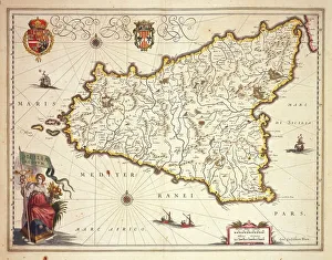
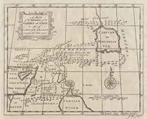
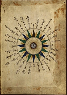
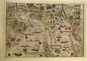
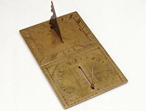
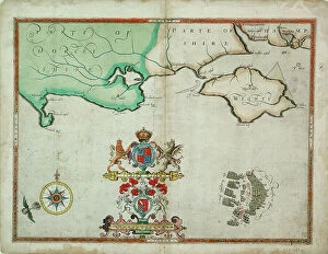
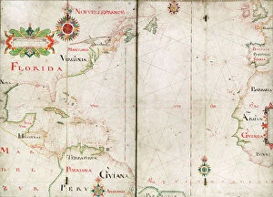
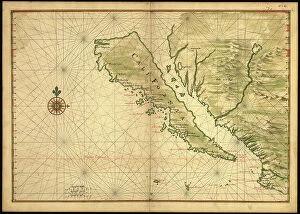
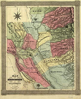
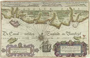
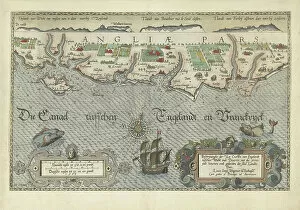
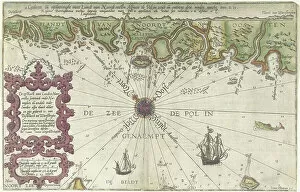
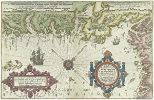
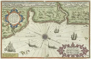
"Exploring the World through Compass Rose: A Journey of Cartographic Marvels" Embark on a captivating voyage through time and space as we unravel the intricate beauty of compass roses adorning historical maps. Let us begin our expedition with Captain John Smith's remarkable Virginia Map from 1612, where the delicate compass rose guides us to uncharted territories. Venturing further, we encounter Joan Blaeu's Sicily region map, adorned with an exquisite compass rose that beckons explorers to navigate its shores. The allure continues with a copperplate engraving published in 1774 depicting Eden and Mount Ararat, showcasing a meticulously crafted compass rose guiding seekers towards paradise. As we delve deeper into cartography's rich tapestry, the Indian Ocean unfolds before our eyes. Melanesia emerges on Mercator projection maps while an Atlas compass from the 16th century stands as a testament to mankind's insatiable curiosity for discovery. Our journey takes an enthralling turn towards India and the Indian Ocean as depicted in Pedro and Jorge Reinel's Miller Atlas from 1519. Here, a masterful blend of cartography meets artistry under Antonio de Holanda’s skilled hand; their creation showcases a mesmerizing compass rose leading intrepid travelers across vast oceans. Returning closer to home, aquamarine watercolor washes over United Kingdom maps evoking coastal charm while sepia tones evoke nostalgia for bygone eras. Meanwhile, taupe hues lend sophistication to these depictions of British landscapes. In this kaleidoscope of exploration, classic world maps painted in vibrant watercolors by Piper or Therese transport us across continents – each adorned with their own unique interpretation of the timeless compass rose symbolizing direction amidst boundless possibilities. Finally, Alheli presents us with her pink watercolor world map embellished with cities – an artistic marvel that reminds us how even within modernity lies room for creativity and wonder.