Home > Animals > Aquatic > Cetacea > Whale
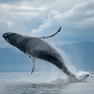
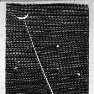
Map of the South England coast between the Isle of Wight and Dover, 1580-83 (engraving)
")
![]()
Wall Art and Photo Gifts from Fine Art Finder
Map of the South England coast between the Isle of Wight and Dover, 1580-83 (engraving)
7415466 Map of the South England coast between the Isle of Wight and Dover, 1580-83 (engraving) by Doetecum, Joannes van (1530-1605); 32.5 -- 50.8 cm; Rijksmuseum, Amsterdam, The Netherlands; (add.info.: By Joannes van Doetechum (I))
Media ID 32180792
© Bridgeman Images
Aquatic Mammal British Channel C16h Cartography Coast Line Compass Card Compass Rose Compass Star Dover English Channel Fishes Flemish Flemish Artist Humpback Whale Isle Of Wight Kent Marine Mammal Marine Mammals Sail Boat Sail Boats Sailboat Sailboats Sailing Boat Sailing Ship Sailing Vessel Sea Mammal Seas Seawater Ships Sail Unpopulated Whale Wind Rose Without People 16 16th Xvi Xvith Sixteenth Century Britisch Britisch Coast Scene Egnland Flemish Art Means Of Conveyance Uk United Kingdom Without Anyone
FEATURES IN THESE COLLECTIONS
> Animals
> Aquatic
> Cetacea
> Whale
> Animals
> Aquatic
> Related Images
> Animals
> Birds
> Columbiformes
> Doves
> Related Images
> Animals
> Fishes
> Related Images
> Animals
> Mammals
> Balaenopteridae
> Humpback Whale
> Animals
> Mammals
> Humpback Whale
> Europe
> Netherlands
> Amsterdam
> Europe
> Netherlands
> Maps
> Europe
> Netherlands
> Posters
> Europe
> Netherlands
> Related Images
> Fine Art Finder
> Artists
> Joannes van Doetecum
> Fine Art Finder
> Artists
> William Blake
EDITORS COMMENTS
This engraving, titled "Map of the South England coast between the Isle of Wight and Dover" offers a fascinating glimpse into the maritime history of 16th-century England. Created by Flemish artist Joannes van Doetecum in 1580-83, this intricate artwork measures 32.5 by 50.8 cm and is currently housed at the Rijksmuseum in Amsterdam. The map showcases the stunning coastline stretching from the Isle of Wight to Dover, providing valuable insights into navigation routes and geographical features during that era. With its meticulous attention to detail, it serves as both a navigational tool and a work of art. As we explore this historical masterpiece, our eyes are drawn to various elements within its composition. The vibrant colors used in this engraved piece bring life to every inch of land and sea depicted on it. From rolling hills to jagged cliffs, each contour is meticulously etched onto paper with remarkable precision. One cannot help but be captivated by the presence of marine mammals gracefully swimming through these waters. A humpback whale majestically breaches above the waves while other aquatic creatures dotting the seascape add an element of enchantment. This map not only provides us with invaluable information about coastal geography but also transports us back in time to an era when exploration was at its peak. It stands as a testament to human curiosity and ingenuity while showcasing Van Doetecum's mastery as an engraver. Through this print from Fine Art Finder brought to you by Bridgeman Images, we can appreciate how art intertwines with cartography, creating a visual representation that transcends mere utility and becomes a true work of art for generations to admire.
MADE IN AUSTRALIA
Safe Shipping with 30 Day Money Back Guarantee
FREE PERSONALISATION*
We are proud to offer a range of customisation features including Personalised Captions, Color Filters and Picture Zoom Tools
SECURE PAYMENTS
We happily accept a wide range of payment options so you can pay for the things you need in the way that is most convenient for you
* Options may vary by product and licensing agreement. Zoomed Pictures can be adjusted in the Cart.