Home > Animals > Mammals > Pitheciidae > Baptista
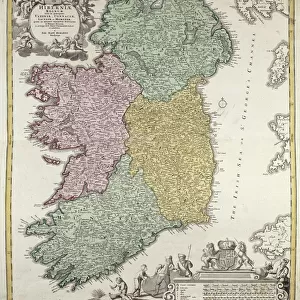
Map of the countries around the Arctic Circle with the three voyages of the Dutch in 1598, 1878 (litho)
")
![]()
Wall Art and Photo Gifts from Fine Art Finder
Map of the countries around the Arctic Circle with the three voyages of the Dutch in 1598, 1878 (litho)
7415818 Map of the countries around the Arctic Circle with the three voyages of the Dutch in 1598, 1878 (litho) by Doetechum, Baptista van (active 1583-1611) (after) ; 43.5 x 56.5 cm; Rijksmuseum, Amsterdam, The Netherlands; (add.info.: print maker: Arnaud A.J. Pistoor, after Baptista van Doetechum)
Media ID 32180428
© Bridgeman Images
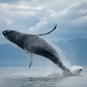
Aquatic Mammal Arctic Arctic Circle C16h Cartography Compass Card Compass Rose Compass Star Danish Denmark Excursion Expedition Explore Finland Finnish Fishes Geographer Greenland Humpback Whale Islands Isles Lithographic Lithos Litography Marine Mammal Marine Mammals North Pole Norway Norway Norwegian Norwegian Norwegians Sail Boat Sail Boats Sailboat Sailboats Sailing Boat Sailing Ship Sailing Vessel Sea Lion Sea Mammal Seal Sealions Ships Sail Unpopulated Whale Wind Rose Without People 16 16th Xvi Xvith Sixteenth Century Dutch Netherlands Hollander Hollanders Means Of Conveyance Mzprint Netherland Netherlands Holland Dutch The Netherland Without Anyone
FEATURES IN THESE COLLECTIONS
> Animals
> Aquatic
> Cetacea
> Whale
> Animals
> Aquatic
> Related Images
> Animals
> Fishes
> Related Images
> Animals
> Mammals
> Balaenopteridae
> Humpback Whale
> Animals
> Mammals
> Humpback Whale
> Animals
> Mammals
> Pitheciidae
> Baptista
> Europe
> Denmark
> Related Images
EDITORS COMMENTS
This print showcases a detailed map of the countries surrounding the Arctic Circle, highlighting the three significant Dutch voyages in 1598 and 1878. Measuring at 43.5 x 56.5 cm, this lithograph is housed in the prestigious Rijksmuseum in Amsterdam, Netherlands. The artist behind this masterpiece is Baptista van Doetechum, an active figure during the late 16th century. The print was later reproduced by Arnaud A. J. Pistoor, paying homage to Doetechum's original work. The map not only serves as a visual representation of geographical features but also sheds light on exploration and cartography during that era. It invites viewers to embark on an imaginary journey through these icy lands while tracing the routes taken by Dutch explorers centuries ago. In addition to its historical significance, this artwork captures the beauty and diversity of marine life within these Arctic waters. Amongst them is a majestic humpback whale gracefully swimming through the sea – a reminder of nature's wonders that await those who dare to venture into uncharted territories. With Finland, Greenland, Denmark, and other Scandinavian countries prominently featured on this map, it offers valuable insights into European geography from both past and present perspectives. Overall, this print stands as a testament to human curiosity and our relentless pursuit of knowledge about our planet's most remote regions.
MADE IN AUSTRALIA
Safe Shipping with 30 Day Money Back Guarantee
FREE PERSONALISATION*
We are proud to offer a range of customisation features including Personalised Captions, Color Filters and Picture Zoom Tools
SECURE PAYMENTS
We happily accept a wide range of payment options so you can pay for the things you need in the way that is most convenient for you
* Options may vary by product and licensing agreement. Zoomed Pictures can be adjusted in the Cart.