Fraud Blocker Skip to main content

Nautical Chart Collection

Discover the captivating world of nautical charts, where art and navigation intertwine

Background imageNautical Chart Collection: The Selden Map of China. Artist: Chinese Master

The Selden Map of China. Artist: Chinese Master
The Selden Map of China. Found in the collection of the Bodleian Library, Oxford

Background imageNautical Chart Collection: Portsmouth and Southampton

Portsmouth and Southampton
Antique map of a Portsmouth and Southampton

Background imageNautical Chart Collection: The Cantino planisphere, 1502. Artist: Anonymous master

The Cantino planisphere, 1502. Artist: Anonymous master
The Cantino planisphere, 1502. Found in the collection of the Biblioteca Estense Universitaria, Modena

Background imageNautical Chart Collection: Pilot's Book of the Majorcan scientist Banet-Paredes, depicting the basin of the Mediterranean Sea

Pilot's Book of the Majorcan scientist Banet-Paredes, depicting the basin of the Mediterranean Sea, Europe and the Black Sea

Background imageNautical Chart Collection: Pilot's Book of a scientist from Siena, Giulio Cesare Petrucci

Pilot's Book of a scientist from Siena, Giulio Cesare Petrucci, depicting the basin of the Mediterranean Sea, Europe and the Black Sea

Background imageNautical Chart Collection: Captain's log depicting the British Islands. The photo was taken for the occasion of

Captain's log depicting the British Islands. The photo was taken for the occasion of the Exhibition of the History of Science from 1929, Florence. The work is preserved in Venice

Background imageNautical Chart Collection: Room with cases in the center and maps on the wall. In the case in the back are different types of

Room with cases in the center and maps on the wall. In the case in the back are different types of magnetic compasses; in the second case are an antique water clock

Background imageNautical Chart Collection: Pilot's book representing a detail of the British Islands. The picture was taken during

Pilot's book representing a detail of the British Islands. The picture was taken during the Exhibition of Science History in 1929, in Florence

Background imageNautical Chart Collection: Pilot?s book of the senese Giulio Cesare Petrucci representing the British Islands

Pilot?s book of the senese Giulio Cesare Petrucci representing the British Islands. The paper is dated 1571 and is preserved in the Astronomic Observatory of Bologna

Background imageNautical Chart Collection: Pilot's Book of the Majorcan scientist, Matteo Brunes depicting the basin of the Mediterranean Sea

Pilot's Book of the Majorcan scientist, Matteo Brunes depicting the basin of the Mediterranean Sea, Europe and the Black Sea. The paper is preserved in the Astronomic Observatory of Bologna

Background imageNautical Chart Collection: Pilot's Book of a scientist from Ancona, Rocco dall'Olmo depicting the basin of the Mediterranean

Pilot's Book of a scientist from Ancona, Rocco dall'Olmo depicting the basin of the Mediterranean Sea, Europe and the Black Sea

Background imageNautical Chart Collection: Carta Pisana, ca 1275-1300. Artist: Anonymous master

Carta Pisana, ca 1275-1300. Artist: Anonymous master
Carta Pisana, ca 1275-1300. Found in the collection of the Bibliotheque Nationale de France

Background imageNautical Chart Collection: Chart of the Mediterranean, Black Sea, and the coasts of western Europe

Chart of the Mediterranean, Black Sea, and the coasts of western Europe
5054668 Chart of the Mediterranean, Black Sea, and the coasts of western Europe and northwest Africa, c.1559 (parchment) by Prunes, Matteo (fl.1560); Private Collection; Italian, out of copyright

Background imageNautical Chart Collection: Detail of tall mast ships from the Nautical Chart by Grazioso Benincasa (Rot)

Detail of tall mast ships from the Nautical Chart by Grazioso Benincasa (Rot. 3), in the University Library of Bologna
3565053 Detail of tall mast ships from the Nautical Chart by Grazioso Benincasa (Rot.3), in the University Library of Bologna

Background imageNautical Chart Collection: Portolan chart of the Mediterranean Sea, the Black Sea, Sea of Azov…, 16th century

Portolan chart of the Mediterranean Sea, the Black Sea, Sea of Azov…, 16th century
Portolan chart of the Mediterranean Sea, the Black Sea, Sea of Azov and Atlantic coasts of Europe and Africa, 16th century. Found in the Collection of Biblioteca Nacional, Madrid

Background imageNautical Chart Collection: Central America, from an Atlas of the World in 33 Maps, Venice, 1st September 1553

Central America, from an Atlas of the World in 33 Maps, Venice, 1st September 1553
XOT330962 Central America, from an Atlas of the World in 33 Maps, Venice, 1st September 1553 (ink on vellum) (detail from 330960) by Agnese, Battista (1514-64); Museo Correr, Venice, Italy; Italian

Background imageNautical Chart Collection: Nautical world map. (Australia is suggested but still unknown territory and, California

Nautical world map. (Australia is suggested but still unknown territory and, California is shown as an island), 1634. Found in the Collection of Bibliothe que Nationale de France

Background imageNautical Chart Collection: Nautical chart, 1558

Nautical chart, 1558. Found in the collection of British Museum

Background imageNautical Chart Collection: Nautical chart of the Mediterranean Sea, 1508

Nautical chart of the Mediterranean Sea, 1508. Found in the collection of Museo Maritimo, Barcelona

Background imageNautical Chart Collection: Nautical chart of the Mediterranean Sea and the Black Sea, 1440s. Artist: Rossell (Rosselli)

Nautical chart of the Mediterranean Sea and the Black Sea, 1440s. Artist: Rossell (Rosselli)
Nautical chart of the Mediterranean Sea and the Black Sea, 1440s. Found in the collection of the Bibliotheque Nationale de France

Background imageNautical Chart Collection: World Map (Propoganda), 1529. Artist: Ribeiro, Diogo (?-1533)

World Map (Propoganda), 1529. Artist: Ribeiro, Diogo (?-1533)
World Map (Propoganda), 1529. Found in the collection of the Biblioteca Apostolica Vaticana

Background imageNautical Chart Collection: Nautical chart portion south coast Portugal Passport chart

Nautical chart portion south coast Portugal Passport chart
Nautical chart of a portion of the south coast of Portugal Passport chart of a portion of the coast of Portugal starting from Zurara to 7 a 8 myl besuyde de Barlenges

Background imageNautical Chart Collection: 1862, U. S. Coast Survey Map of the Kennebec and Sheepscot Rivers, Maine, Nautical Chart

1862, U. S. Coast Survey Map of the Kennebec and Sheepscot Rivers, Maine, Nautical Chart
1862, U.S. Coast Survey Map of the Kennebec and Sheepscot Rivers, Maine, Nautical Chart

Background imageNautical Chart Collection: Victorian map of the North Polar Regions

Victorian map of the North Polar Regions
Vintage engraving showing a Victorian map of the North Polar Regions

Background imageNautical Chart Collection: Map of plant geography

Map of plant geography

Background imageNautical Chart Collection: Maps for history of geography

Maps for history of geography

Background imageNautical Chart Collection: The Pacific Ocean, from an Atlas of the World in 33 Maps, Venice, 1st September 1553

The Pacific Ocean, from an Atlas of the World in 33 Maps, Venice, 1st September 1553
XOT330960 The Pacific Ocean, from an Atlas of the World in 33 Maps, Venice, 1st September 1553 (ink on vellum) (see also 330962) by Agnese, Battista (1514-64); 29x49 cm; Museo Correr, Venice

Background imageNautical Chart Collection: India and Malaysia, from an Atlas of the World in 33 Maps, Venice, 1st September 1553

India and Malaysia, from an Atlas of the World in 33 Maps, Venice, 1st September 1553
XOT330958 India and Malaysia, from an Atlas of the World in 33 Maps, Venice, 1st September 1553 (ink on vellum) (detail from 330955) by Agnese, Battista (1514-64); Museo Correr, Venice

Background imageNautical Chart Collection: The Indian Ocean, from an Atlas of the World in 33 Maps, Venice, 1st September 1553

The Indian Ocean, from an Atlas of the World in 33 Maps, Venice, 1st September 1553
XOT330955 The Indian Ocean, from an Atlas of the World in 33 Maps, Venice, 1st September 1553 (ink on vellum) (see also 330956) by Agnese, Battista (1514-64); 29x49 cm; Museo Correr, Venice

Background imageNautical Chart Collection: The New World, from an Atlas of the World in 33 Maps, Venice, 1st September 1553

The New World, from an Atlas of the World in 33 Maps, Venice, 1st September 1553
XOT330959 The New World, from an Atlas of the World in 33 Maps, Venice, 1st September 1553 (ink on vellum) (see also 330961) by Agnese, Battista (1514-64); 29x49 cm; Museo Correr, Venice

Background imageNautical Chart Collection: Madagascar, from an Atlas of the World in 33 Maps, Venice, 1st September 1553 (ink on vellum)

Madagascar, from an Atlas of the World in 33 Maps, Venice, 1st September 1553 (ink on vellum)
XOT330957 Madagascar, from an Atlas of the World in 33 Maps, Venice, 1st September 1553 (ink on vellum) (detail from 330955) by Agnese, Battista (1514-64); Museo Correr, Venice, Italy; Italian

Background imageNautical Chart Collection: Part of Africa, from an Atlas of the World in 33 Maps, Venice, 1st September 1553

Part of Africa, from an Atlas of the World in 33 Maps, Venice, 1st September 1553
XOT330956 Part of Africa, from an Atlas of the World in 33 Maps, Venice, 1st September 1553 (ink on vellum) (detail from 330955) by Agnese, Battista (1514-64); Museo Correr, Venice, Italy; Italian

Background imageNautical Chart Collection: The Continent of Europe, from an Atlas of the World in 33 Maps, Venice, 1st September 1553

The Continent of Europe, from an Atlas of the World in 33 Maps, Venice, 1st September 1553
XOT330949 The Continent of Europe, from an Atlas of the World in 33 Maps, Venice, 1st September 1553 (ink on vellum) (see also 330950) by Agnese, Battista (1514-64); 29x49 cm; Museo Correr, Venice

Background imageNautical Chart Collection: The Kingdoms of England and Scotland, from an Atlas of the World in 33 Maps, Venice

The Kingdoms of England and Scotland, from an Atlas of the World in 33 Maps, Venice
XOT330950 The Kingdoms of England and Scotland, from an Atlas of the World in 33 Maps, Venice, 1st September 1553 (ink on vellum) (detail from 330949) by Agnese, Battista (1514-64); Museo Correr

Background imageNautical Chart Collection: Portrait of David Vlugh, print maker: Hendrik Bary, Jan de Bisschop, Egbert van den Hoof

Portrait of David Vlugh, print maker: Hendrik Bary, Jan de Bisschop, Egbert van den Hoof, 1667 - 1707

Background imageNautical Chart Collection: Nautical charts by Angelino Dulcert, two sheets of parchment glued, 1339

Nautical charts by Angelino Dulcert, two sheets of parchment glued, 1339
Cartography, 14th century. Nautical charts by Angelino Dulcert, 1339. Two sheets of parchment glued, 102 x 75 cm

Background imageNautical Chart Collection: Nautical chart of Mediterranean Sea by Francesco Rosselli, 15th-16th Century

Nautical chart of Mediterranean Sea by Francesco Rosselli, 15th-16th Century
Cartography, 11th century. Nautical chart of the Mediterranean Sea, designed by Francesco Rosselli

Background imageNautical Chart Collection: Nautical chart of limits of the North Sea by Hessel Gerritsz, 17th Century

Nautical chart of limits of the North Sea by Hessel Gerritsz, 17th Century
Cartography, 17th century. Nautical chart of the limits of the North Sea, created by Hessel Gerritsz


All Professionally Made to Order for Quick Shipping

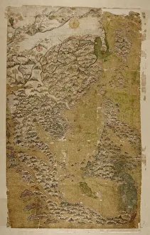
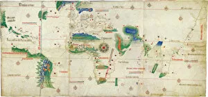
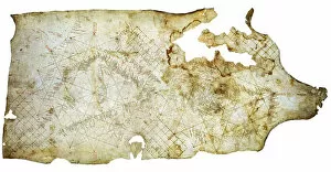
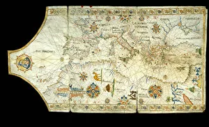
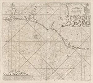
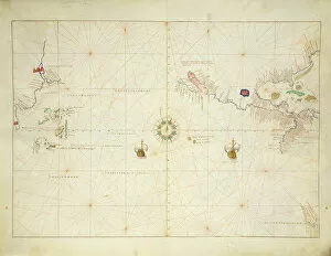
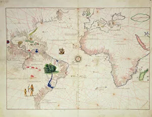
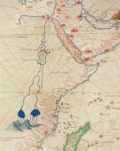
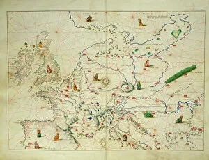
Discover the captivating world of nautical charts, where art and navigation intertwine. From the intricate details of the Selden Map of China, crafted by a Chinese master, to the Portsmouth and Southampton maps that guided sailors through treacherous waters. Dive into ocean currents with a mesmerizing map showcasing their ebb and flow. Uncover mysteries with the enigmatic Cantino planisphere, an anonymous masterpiece from 1502. Marvel at tall mast ships depicted in Grazioso Benincasa's Nautical Chart, transporting you back in time to an era of exploration. Traverse the Mediterranean Sea, Black Sea, and western European coasts through a meticulously crafted chart. Embark on a visual journey as you explore a portolan chart depicting seas like Azov in stunning detail during the 16th century. Witness Central America come alive in an Atlas of the World from Venice dated September 1st, 1553. Encounter uncharted territories such as Australia and California on an intriguing nautical world map. Immerse yourself further with historical gems like a nautical chart from 1558 or delve into ancient navigational knowledge with a Mediterranean Sea chart dating back to 1508. Finally, let Pere Rossell's exquisite craftsmanship transport you to the Black Sea region during his active years between 1446-1489. These remarkable nautical charts not only served as vital tools for seafarers but also stand as testaments to human ingenuity and artistic prowess throughout history. Step aboard this voyage through time and witness how these extraordinary works shaped our understanding of oceans and distant lands.