Fraud Blocker Skip to main content

Pitsmoor Collection

Background imagePitsmoor Collection: Ordnance Survey Map, Fowler Street, Pitsmoor area of Sheffield, 1889 (Yorkshire sheet no. 294. 4)

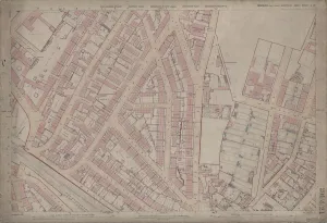
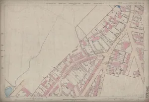
Ordnance Survey Map, Fowler Street, Pitsmoor area of Sheffield, 1889 (Yorkshire sheet no. 294. 4. 21)
This map features: Top left: Rutland Road, [Woodside Board School] School (Girls and Infants), Playground, Botsford Street, Rutland Street, Woodside Lane Birley Street, Fowler Street, Grove Street

Background imagePitsmoor Collection: Ordnance Survey Map, Pitsmoor area of Sheffield, 1889 (Yorkshire sheet 294. 4. 16)

Ordnance Survey Map, Pitsmoor area of Sheffield, 1889 (Yorkshire sheet 294. 4. 16)
This map features Top left: n/a [blank] Top right: Pitsmoor Road, Nottingham Street, Forton Lodge, Throstle Grove, Vicarage [Christ Church Pitsmoor], Wood Fold, Woodside House, Brittain Villas

Background imagePitsmoor Collection: Christ Church, Pitsmoor, Sheffield (engraving)

Christ Church, Pitsmoor, Sheffield (engraving)
1096774 Christ Church, Pitsmoor, Sheffield (engraving) by English School, (19th century); Private Collection; (add.info.: Christ Church, Pitsmoor, Sheffield)

Background imagePitsmoor Collection: Sheffield S3 9 Map

Sheffield S3 9 Map
Postcode Sector Map of Sheffield S3 9

Background imagePitsmoor Collection: Map of the Pitsmoor district in the Parish of Sheffield, 1846

Map of the Pitsmoor district in the Parish of Sheffield, 1846
Size 21 x 15 cm. Original at Local Studies Library: S(15)4VS

Background imagePitsmoor Collection: Plan of Nottingham Cliff Recreation Ground, 1897

Plan of Nottingham Cliff Recreation Ground, 1897
Image from Sheffield City Council, General Purposes and Parks Committee - Plans and Description of Parks and Recreation Grounds (Local Studies Library 352.7 SQ)

Background imagePitsmoor Collection: Pyebank School, Andover Street, Architects Design, 1874

Pyebank School, Andover Street, Architects Design, 1874
In the Ecclesiastical District of Pitsmoor, in Andover Street West, and Nottingham Cliff.The site, which is freehold, contains 2500 square yards, nett

Background imagePitsmoor Collection: Royal Visit of Prince and Princess of Wales, decorative arch at Pitsmoor Toll Bar, sheffield, 1875

Royal Visit of Prince and Princess of Wales, decorative arch at Pitsmoor Toll Bar, sheffield, 1875
Full title: Royal Visit of Prince and Princess of Wales, decorative arch at Pitsmoor Toll Bar, Barnsley Road/Burngreave Rod From an original at Sheffield Libraries: y00772

Background imagePitsmoor Collection: Toll Bar House, Pitsmoor, Burngreave Road / Pitsmoor Road (right)

Toll Bar House, Pitsmoor, Burngreave Road / Pitsmoor Road (right)
Built 1836 with gates that swung across Pitsmoor Road and Burngreave Road replacing the earlier one of 1759

Background imagePitsmoor Collection: Sheffield and Wakefield Turpike Road - tolls to be let by auction, 1836

Sheffield and Wakefield Turpike Road - tolls to be let by auction, 1836
Also the Pitsmoor Toll Bar to be moved, etc. Printed by G. Ridge, printer, Mercuty Office, Sheffield.Original at Sheffield Local Studies Library: MP 57 M

Background imagePitsmoor Collection: Pitsmoor Road, Sheffield, looking towards Christ Church, 1881

Pitsmoor Road, Sheffield, looking towards Christ Church, 1881
Artist: John Taylor. From an original at Sheffield Libraries: s18792


All Professionally Made to Order for Quick Shipping