Home > Maps and Charts > Related Images
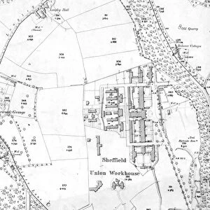
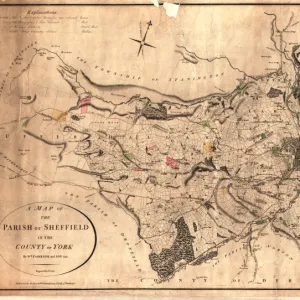
Map of the Pitsmoor district in the Parish of Sheffield, 1846

![]()
Wall Art and Photo Gifts from Sheffield City Archives
Map of the Pitsmoor district in the Parish of Sheffield, 1846
Size 21 x 15 cm. Original at Local Studies Library: S(15)4VS
Sheffield City Archives and Local Studies Library has an unrivalled collection of images of Sheffield, England
Media ID 14047699
© Sheffield City Council
FEATURES IN THESE COLLECTIONS
> Maps and Charts
> Related Images
> Sheffield City Archives
> Maps and Plans
EDITORS COMMENTS
This print showcases a historical gem, the "Map of the Pitsmoor district in the Parish of Sheffield, 1846". Measuring at a modest size of 21 x 15 cm, this original piece can be found at the esteemed Local Studies Library: S (15)4VS within Sheffield City Archives. Transporting us back to an era long gone, this map provides a fascinating glimpse into the vibrant community that once thrived in Pitsmoor. With intricate details and precise cartography, it unveils the layout and structure of this district during its formative years. Every street corner, building, and landmark is meticulously depicted on this remarkable artifact. As we immerse ourselves in its rich history, we discover how Pitsmoor evolved from humble beginnings into a bustling hub within Sheffield's parish. The map serves as an invaluable resource for researchers and enthusiasts alike who seek to understand urban development patterns or trace their ancestral roots. Beyond its academic significance lies an aesthetic appeal that cannot be ignored. The delicate lines and faded hues evoke nostalgia while reminding us of our connection to those who came before us. This print acts as a portal through time—a tangible link between past and present. While commercial use is not mentioned here due to restrictions associated with copyright laws or licensing agreements, one cannot deny the immense value this map holds for educational purposes or personal enrichment. It stands as both a testament to human progress and a tribute to those who shaped Pitsmoor's identity
MADE IN AUSTRALIA
Safe Shipping with 30 Day Money Back Guarantee
FREE PERSONALISATION*
We are proud to offer a range of customisation features including Personalised Captions, Color Filters and Picture Zoom Tools
SECURE PAYMENTS
We happily accept a wide range of payment options so you can pay for the things you need in the way that is most convenient for you
* Options may vary by product and licensing agreement. Zoomed Pictures can be adjusted in the Cart.

![A map of the lands at and near Crooks [Crookes] part in Ecclesall and part in Nether Hallam, 1790](/sq/716/map-lands-near-crooks-crookes-ecclesall-nether-14049486.jpg.webp)