Home > North America > United States of America > Georgia > Atlanta
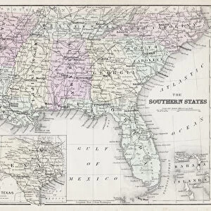
Map illustrating the Siege of Atlanta, Georgia, by the U. S. Forces under the command of Major General William Tecumseh Sherman, May-September 1864

![]()
Wall Art and Photo Gifts from Granger
Map illustrating the Siege of Atlanta, Georgia, by the U. S. Forces under the command of Major General William Tecumseh Sherman, May-September 1864
MAP: SIEGE OF ATLANTA 1864.
Map illustrating the Siege of Atlanta, Georgia, by the U.S. Forces under the command of Major General William Tecumseh Sherman, May-September 1864
Granger holds millions of images spanning more than 25,000 years of world history, from before the Stone Age to the dawn of the Space Age
Media ID 10409298
1864 Atlanta Canvassing Major Marching Plan September Sherman Siege Tecumseh Union Union Army United States William Yankee Southeast
FEATURES IN THESE COLLECTIONS
> Arts
> Landscape paintings
> Waterfall and river artworks
> River artworks
> Granger Art on Demand
> Maps
> Granger Art on Demand
> Plans and Diagrams
> North America
> United States of America
> Georgia
> Atlanta
EDITORS COMMENTS
This print showcases a historically significant map illustrating the intense Siege of Atlanta, Georgia, during the American Civil War. The map depicts the strategic movements and plans of the U. S. Forces led by Major General William Tecumseh Sherman from May to September 1864. As one gazes at this intricate piece, they are transported back in time to witness the relentless march of Union soldiers through the middle and southern regions of America. The image captures Major General Sherman's meticulous canvassing of Atlanta as he masterminded his siege plan against Confederate forces. It serves as a testament to his unwavering determination and tactical brilliance that ultimately led to victory for the Union Army. The significance of this historical event cannot be overstated; it marked a turning point in the war and solidified Sherman's reputation as one of America's greatest military leaders. This print allows us to appreciate not only the artistry behind cartography but also its ability to convey vital information during times of conflict. As we delve into this visual representation, we can almost hear echoes from history: cannon fire reverberating across battlefields, troops marching with Yankee resolve, and rivers flowing symbolically between divided states. This powerful image reminds us of our nation's past struggles while honoring those who fought bravely for their cause on both sides.
MADE IN AUSTRALIA
Safe Shipping with 30 Day Money Back Guarantee
FREE PERSONALISATION*
We are proud to offer a range of customisation features including Personalised Captions, Color Filters and Picture Zoom Tools
SECURE PAYMENTS
We happily accept a wide range of payment options so you can pay for the things you need in the way that is most convenient for you
* Options may vary by product and licensing agreement. Zoomed Pictures can be adjusted in the Cart.