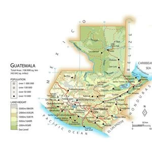
Home > North America > Guatemala > Maps
PACIFIC COAST MAP, 1600s. English map of the Pacific coast of Central and South America, probably 17th century

![]()
Wall Art and Photo Gifts from Granger
PACIFIC COAST MAP, 1600s. English map of the Pacific coast of Central and South America, probably 17th century
Granger holds millions of images spanning more than 25,000 years of world history, from before the Stone Age to the dawn of the Space Age
Media ID 7560159
17th Century Central America Chile Coast Geography Guatemala Marine Navigation Nicaragua Pacific Panama Peru South America Patagonia
FEATURES IN THESE COLLECTIONS
> North America
> Guatemala
> Maps
> North America
> Nicaragua
> Maps
> North America
> Panama
> Maps
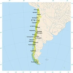
> South America
> Chile
> Maps
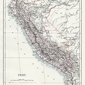
> South America
> Peru
> Maps
EDITORS COMMENTS
This print showcases a remarkable English map of the Pacific coast of Central and South America, believed to have been created in the 17th century. The intricate engraving depicts a comprehensive representation of the coastal regions, offering an invaluable glimpse into the geography and marine navigation of that era. The map spans from Panama to Chile, encompassing countries such as Guatemala, Peru, Nicaragua, and Patagonia. Its meticulous details highlight major landmarks and geographical features along this vast coastline. Nautical enthusiasts will be enthralled by the accuracy with which this ancient cartographer captured every bay, inlet, and promontory. As we delve into history through this mesmerizing piece of art from Granger Art on Demand's Carousel Collection, it is evident that this map served as an indispensable tool for explorers venturing across these uncharted waters centuries ago. It not only facilitated trade routes but also provided vital information for early settlers seeking new lands in Central and South America. The craftsmanship exhibited in this print is truly exceptional; each stroke meticulously etched onto paper tells a story of adventure and discovery. Whether you are fascinated by historical maps or simply appreciate fine engravings from the past, this Pacific Coast Map transports you back to an era when maritime exploration was at its peak.
MADE IN AUSTRALIA
Safe Shipping with 30 Day Money Back Guarantee
FREE PERSONALISATION*
We are proud to offer a range of customisation features including Personalised Captions, Color Filters and Picture Zoom Tools
SECURE PAYMENTS
We happily accept a wide range of payment options so you can pay for the things you need in the way that is most convenient for you
* Options may vary by product and licensing agreement. Zoomed Pictures can be adjusted in the Cart.