Greetings Card > Fine Art Storehouse > Map
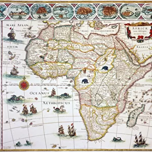
Greetings Card : Map of the World 1883
![]()

Cards from Fine Art Storehouse
Map of the World 1883
Warrens Common School Geography
Unleash your creativity and transform your space into a visual masterpiece!
THEPALMER
Media ID 13669325
© This content is subject to copyright
North America Paper South America
Greetings Card (7"x5")
Discover the wonders of our interconnected world with Media Storehouse's exquisite range of greeting cards. Featuring the captivating Map of the World 1883 by THEPALMER from Fine Art Storehouse, these cards transport you back in time to the intriguing era of Warrens Common School Geography. Express your thoughts and feelings with a touch of history and elegance. Whether for birthdays, anniversaries, or just to say hello, our Map of the World greeting cards are a unique and thoughtful choice.
Folded Greeting Cards (12.5x17.5 cm) have a laminate finish and are supplied with an envelope. The front and inside can be personalised with text in a selection of fonts, layouts and colours.
Greetings Cards suitable for Birthdays, Weddings, Anniversaries, Graduations, Thank You and much more
Estimated Product Size is 12.5cm x 17.5cm (4.9" x 6.9")
These are individually made so all sizes are approximate
Artwork printed orientated as per the preview above, with landscape (horizontal) or portrait (vertical) orientation to match the source image.
FEATURES IN THESE COLLECTIONS
> Fine Art Storehouse
> The Magical World of Illustration
> Palmer Illustrated Collection
> Fine Art Storehouse
> Map
> Historical Maps
EDITORS COMMENTS
This photo print, titled "Map of the World 1883 (Warrens Common School Geography)" by THEPALMER, takes us on a mesmerizing journey through time. The image showcases an exquisite piece of history that beautifully captures the essence of cartography in the late 19th century. The map itself is a true work of art, meticulously engraved onto aged paper with intricate details and precision. It offers a glimpse into how our world was perceived over a century ago, presenting Europe, Asia, Africa, North America, South America, and even the United States in their geographical glory. As we gaze upon this antique masterpiece, we are transported back to an era when physical geography played a vital role in understanding our planet's vastness. The engraving technique used adds depth and texture to every contour line and coastline depicted on this remarkable map. With its faded colors and delicate lines etched onto paper that has stood the test of time, this print evokes nostalgia for simpler times when maps were cherished possessions guiding explorers across uncharted territories. "The Map of the World 1883" invites us to appreciate not only its historical significance but also its artistic value. It serves as a reminder that knowledge is ever-evolving; what once represented truth may now be seen through different lenses. This photograph preserves both the beauty and educational importance encapsulated within this stunning piece from THEPALMER's collection at Fine Art Storehouse.
MADE IN AUSTRALIA
Safe Shipping with 30 Day Money Back Guarantee
FREE PERSONALISATION*
We are proud to offer a range of customisation features including Personalised Captions, Color Filters and Picture Zoom Tools
SECURE PAYMENTS
We happily accept a wide range of payment options so you can pay for the things you need in the way that is most convenient for you
* Options may vary by product and licensing agreement. Zoomed Pictures can be adjusted in the Cart.


