Greetings Card > North America > United States of America > New York > New York > Maps
Greetings Card : Palestine map 1875


![]()
Cards from Fine Art Storehouse
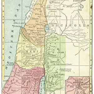
Palestine map 1875
The Independent Course Comprehensive Geography by James Monteith, A.S. Barnes & Co, New York & Chicago 1875
Unleash your creativity and transform your space into a visual masterpiece!
THEPALMER
Media ID 13612199
© This content is subject to copyright
Globe Navigational Equipment Palestine Paper Drawing Art Product Palestinian Territories
Greetings Card (7"x5")
Introducing the Media Storehouse collection of beautifully crafted greeting cards, featuring the captivating "Palestine Map 1875" by THEPALMER from the Fine Art Storehouse. Each card showcases a high-quality reproduction of this intriguing historical map, taken from The Independent Course in Comprehensive Geography by James Monteith, published by A.S. Barnes & Co, New York & Chicago in 1875. Transport your recipients back in time as they admire the intricate detail and vintage charm of this antique map, making for a unique and thoughtful greeting. Whether for a history buff, an avid collector, or someone who appreciates the beauty of the past, these cards are sure to leave a lasting impression. Order yours today and add a touch of history to your correspondence.
Folded Greeting Cards (12.5x17.5 cm) have a laminate finish and are supplied with an envelope. The front and inside can be personalised with text in a selection of fonts, layouts and colours.
Greetings Cards suitable for Birthdays, Weddings, Anniversaries, Graduations, Thank You and much more
Estimated Product Size is 17.5cm x 12.5cm (6.9" x 4.9")
These are individually made so all sizes are approximate
Artwork printed orientated as per the preview above, with landscape (horizontal) or portrait (vertical) orientation to match the source image.
FEATURES IN THESE COLLECTIONS
> Fine Art Storehouse
> The Magical World of Illustration
> Palmer Illustrated Collection
> Fine Art Storehouse
> Map
> Historical Maps
> Asia
> Palestine
> Related Images
> Maps and Charts
> Related Images
> North America
> United States of America
> Maps
> North America
> United States of America
> New York
> New York
> Maps
> North America
> United States of America
> New York
> Related Images
EDITORS COMMENTS
This print showcases a historical gem, the "Palestine map 1875" from James Monteith's renowned book, "The Independent Course Comprehensive Geography". Published by A. S. Barnes & Co in New York and Chicago back in 1875, this exquisite piece of cartography takes us on a journey through time. The image captures the essence of an era when maps were meticulously hand-drawn and engraved with utmost precision. Displayed vertically against a backdrop of nature's beauty, this old paper print exudes an air of authenticity that transports us to the past. Its intricate details are brought to life through delicate etching and engraving techniques, showcasing the mastery of artistry during that period. As we gaze upon this antique masterpiece, our eyes are drawn to Palestine's geographical features depicted with great accuracy. This illustration serves as a valuable resource for understanding the physical geography of Palestinian territories at that time. "The Palestine map 1875" is not just an ordinary drawing; it represents a significant milestone in cartographic history. It reminds us how far we have come in terms of navigational equipment and mapping technologies since then. Courtesy of THEPALMER from Fine Art Storehouse, this print allows us to appreciate both its artistic value and historical significance. It serves as a reminder that art can transcend time and space while providing insight into our world's rich heritage.
MADE IN AUSTRALIA
Safe Shipping with 30 Day Money Back Guarantee
FREE PERSONALISATION*
We are proud to offer a range of customisation features including Personalised Captions, Color Filters and Picture Zoom Tools
SECURE PAYMENTS
We happily accept a wide range of payment options so you can pay for the things you need in the way that is most convenient for you
* Options may vary by product and licensing agreement. Zoomed Pictures can be adjusted in the Cart.