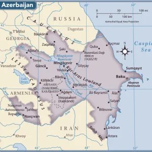
Greetings Card > Asia > Iran > Lakes > Caspian Sea
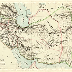
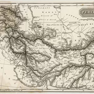
Greetings Card : Ancient map of Persia, lithograph, published in 1877


![]()
Cards from Fine Art Storehouse
Ancient map of Persia, lithograph, published in 1877
Ancient map of Persia. Lithograph, published in 1877
Unleash your creativity and transform your space into a visual masterpiece!
Media ID 13666775
© ZU_09
78279 Azerbaijan Caspian Sea Contour Drawing Country Geographic Area Ethnocultural History Iran Iraq Land Middle East Ninawa Persian Culture Persian Gulf Persian Gulf Countries Topographic Map Topography Arbil Baghdad Erbil Image Created 19th Century Kurdistan Mosul Tehran Yerevan
Greetings Card (7"x5")
"Step back in time with our exquisite Ancient Map of Persia Greeting Cards from Media Storehouse. These beautifully crafted cards feature a captivating lithograph, published in 1877, showcasing an intricate and detailed representation of the ancient Persian empire. Transport your loved ones to a world of history and culture with each thoughtful message. Perfect for birthdays, anniversaries, or just to brighten someone's day, these unique cards are a thoughtful and artistic expression of your affection. Add a touch of history to your correspondence with Media Storehouse's Ancient Map of Persia Greeting Cards."
Folded Greeting Cards (12.5x17.5 cm) have a laminate finish and are supplied with an envelope. The front and inside can be personalised with text in a selection of fonts, layouts and colours.
Greetings Cards suitable for Birthdays, Weddings, Anniversaries, Graduations, Thank You and much more
Estimated Product Size is 12.5cm x 17.5cm (4.9" x 6.9")
These are individually made so all sizes are approximate
Artwork printed orientated as per the preview above, with landscape (horizontal) or portrait (vertical) orientation to match the source image.
FEATURES IN THESE COLLECTIONS
> Fine Art Storehouse
> Map
> Historical Maps
> Asia
> Azerbaijan
> Lakes
> Caspian Sea
> Asia
> Azerbaijan
> Maps
> Asia
> Azerbaijan
> Related Images
> Asia
> Iran
> Lakes
> Caspian Sea
> Asia
> Iran
> Related Images
> Asia
> Iraq
> Related Images
EDITORS COMMENTS
This lithograph, published in 1877, showcases an ancient map of Persia that takes us on a journey through time. With its intricate details and exquisite craftsmanship, this engraved image offers a glimpse into the rich history and culture of the Persian Gulf countries. The topographic map spans across Erbil, Tehran, Yerevan, Ninawa, Mosul, Baghdad and other significant capital cities of the Middle East. It beautifully captures the land encompassing Iraq and Iran while highlighting key geographical features such as the Caspian Sea and Persian Gulf. As we delve into this antique piece from the 19th century, we are transported to a bygone era where cartography played a vital role in understanding our world. The horizontal layout allows us to explore every contour drawing with awe-inspiring precision. Beyond its aesthetic appeal lies a deeper significance - it serves as a testament to the ethnocultural history of Azerbaijan and Kurdistan. This print encapsulates not only borders but also narratives woven by diverse communities inhabiting this country geographic area. Whether you are an avid collector or simply fascinated by historical artifacts, this lithograph is sure to captivate your imagination. Let it transport you back in time as you marvel at the beauty of ancient Persia captured within its delicate lines.
MADE IN AUSTRALIA
Safe Shipping with 30 Day Money Back Guarantee
FREE PERSONALISATION*
We are proud to offer a range of customisation features including Personalised Captions, Color Filters and Picture Zoom Tools
SECURE PAYMENTS
We happily accept a wide range of payment options so you can pay for the things you need in the way that is most convenient for you
* Options may vary by product and licensing agreement. Zoomed Pictures can be adjusted in the Cart.