Greetings Card > Fine Art Storehouse > Map
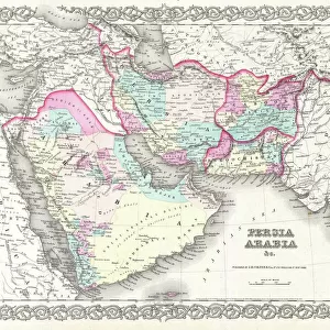
Greetings Card : Antique map of Arabia and adjacent Africa and Persia


![]()
Cards from Fine Art Storehouse
Antique map of Arabia and adjacent Africa and Persia
Unleash your creativity and transform your space into a visual masterpiece!
Hemera Technologies
Media ID 13609519
© Getty Images
Abyssinia Arabia Border Coordinates Direction Document Egypt Ethiopia Geography Horn Horn Of Africa Indian Ocean Israel Jordan Jordan Middle East Latitude Legend Libya Location Longitude Middle East Nile River Nubia Persian Gulf Place Positioning Red Sea Scale Sudan Lybia
Greetings Card (7"x5")
Discover the rich history and culture of Arabia, Africa, and Persia with our exquisite Antique Map Greeting Cards from Media Storehouse, in partnership with Fine Art Storehouse and Hemera Technologies. Each card features a beautifully detailed antique map, showcasing the intricate borders and geographical features of the region during a bygone era. Perfect for history enthusiasts or as a thoughtful and unique gift, these cards are a beautiful way to express your sentiments while transporting the recipient on a journey through time. Add a personal touch with a handwritten message and make every occasion a memorable one.
Folded Greeting Cards (12.5x17.5 cm) have a laminate finish and are supplied with an envelope. The front and inside can be personalised with text in a selection of fonts, layouts and colours.
Greetings Cards suitable for Birthdays, Weddings, Anniversaries, Graduations, Thank You and much more
Estimated Product Size is 12.5cm x 17.5cm (4.9" x 6.9")
These are individually made so all sizes are approximate
Artwork printed orientated as per the preview above, with landscape (horizontal) or portrait (vertical) orientation to match the source image.
FEATURES IN THESE COLLECTIONS
> Fine Art Storehouse
> Map
> Historical Maps
EDITORS COMMENTS
This print showcases an exquisite antique map of Arabia, adjacent Africa, and Persia. A true testament to the artistry of cartography, this archival piece takes us on a historical journey through time. The intricate details and precision engraving transport us to a bygone era where explorers relied on maps like these for navigation. The map encompasses vast regions including Abyssinia, Egypt, Israel, Jordan, Libya, Nubia, Sudan, and the Horn of Africa. It highlights key geographical features such as the Nile River, Red Sea, Persian Gulf, Indian Ocean and more. With its carefully marked coordinates and legends denoting important locations and borders along with a scale for accurate measurement - it becomes a valuable document that reveals the knowledge of ancient civilizations. Displayed in horizontal format with vibrant colors preserved over time; this vintage masterpiece evokes a sense of wonder about our world's rich history. As we gaze upon it without any human presence captured within its frame or modern distractions surrounding it; we are reminded of the importance placed on physical geography during those times. Photographed by Hemera Technologies for Fine Art Storehouse - this image allows us to appreciate both the beauty and significance behind antique maps while igniting our curiosity about past cultures' understanding of their surroundings.
MADE IN AUSTRALIA
Safe Shipping with 30 Day Money Back Guarantee
FREE PERSONALISATION*
We are proud to offer a range of customisation features including Personalised Captions, Color Filters and Picture Zoom Tools
SECURE PAYMENTS
We happily accept a wide range of payment options so you can pay for the things you need in the way that is most convenient for you
* Options may vary by product and licensing agreement. Zoomed Pictures can be adjusted in the Cart.