Greetings Card > Arts > Street art graffiti > Digital art > Digital paintings
Greetings Card : Early Map of the City and Capitol of Washington, D. C. United States, Antique American Illustration, 1900


![]()
Cards from Fine Art Storehouse
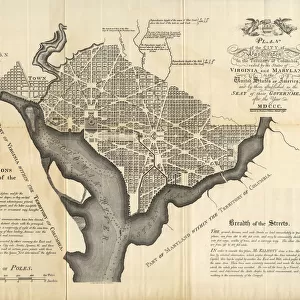
Early Map of the City and Capitol of Washington, D. C. United States, Antique American Illustration, 1900
Antique American Photograph: Early Map of the City and Capitol of Washington, D.C. United States, Antique American Illustration, 1900: Original edition from my own archives. Copyright has expired on this artwork. Digitally restored. Historic maps of the city were featured in 1900 as part of the Washington D.C. Centennial Celebration
Unleash your creativity and transform your space into a visual masterpiece!
bauhaus1000
Media ID 15488351
© This content is subject to copyright
Greetings Card (7"x5")
Step back in time with our exquisite Early Map of the City and Capitol of Washington, D.C. Greeting Card from Media Storehouse. This antique illustration, created in 1900 by bauhaus1000, showcases an intricately detailed map of the early days of the United States capital. The vintage charm of this fine art print is sure to transport you back to an era of history, making it a thoughtful and unique gift for history enthusiasts, collectors, or anyone who appreciates the beauty of the past. Order now and add a touch of timeless elegance to your correspondence.
Folded Greeting Cards (12.5x17.5 cm) have a laminate finish and are supplied with an envelope. The front and inside can be personalised with text in a selection of fonts, layouts and colours.
Greetings Cards suitable for Birthdays, Weddings, Anniversaries, Graduations, Thank You and much more
Estimated Product Size is 17.5cm x 12.5cm (6.9" x 4.9")
These are individually made so all sizes are approximate
Artwork printed orientated as per the preview above, with landscape (horizontal) or portrait (vertical) orientation to match the source image.
FEATURES IN THESE COLLECTIONS
> Fine Art Storehouse
> Map
> Historical Maps
> Arts
> Street art graffiti
> Digital art
> Digital paintings
> Maps and Charts
> Early Maps
> Maps and Charts
> Related Images
EDITORS COMMENTS
This print showcases an early map of the city and Capitol of Washington, D. C. , dating back to 1900. The antique American illustration takes us on a journey through time, offering a glimpse into the rich history and development of this iconic city. With its original edition sourced from the archives of bauhaus1000, this artwork holds immense historical value. The digitized restoration process has breathed new life into this piece, allowing us to appreciate intricate details that may have faded over time. This remarkable map was prominently featured during the Washington D. C. Centennial Celebration in 1900, serving as a testament to the significance and pride associated with our nation's capital. As we explore this vintage masterpiece, we are transported back to an era when Washington D. C. 's landscape was still evolving. Streets were laid out meticulously while landmarks such as the Capitol building stood tall amidst a growing metropolis. This photograph invites us to reflect upon how far our beloved city has come since its humble beginnings. With copyright restrictions expired on this artwork, it is now available for all enthusiasts of history and art alike to enjoy freely. Let this stunning print grace your walls and serve as a reminder of the enduring legacy embedded within every corner of Washington D. C. 's streetscape.
MADE IN AUSTRALIA
Safe Shipping with 30 Day Money Back Guarantee
FREE PERSONALISATION*
We are proud to offer a range of customisation features including Personalised Captions, Color Filters and Picture Zoom Tools
SECURE PAYMENTS
We happily accept a wide range of payment options so you can pay for the things you need in the way that is most convenient for you
* Options may vary by product and licensing agreement. Zoomed Pictures can be adjusted in the Cart.