Greetings Card > Arts > Artists > O > Oceanic Oceanic
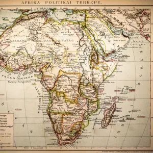
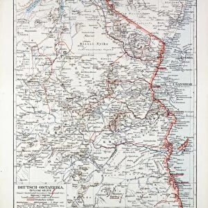
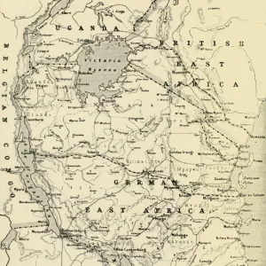
Greetings Card : Map of formerly German colony East Africa, lithograph, published 1897


![]()
Cards from Fine Art Storehouse
Map of formerly German colony East Africa, lithograph, published 1897
Map of the formerly German colony East Africa between 1885 and 1918, (present-day Burundi, Rwanda, and the mainland part of Tanzania). Lithograph, published in 1897
Unleash your creativity and transform your space into a visual masterpiece!
Media ID 14756162
© This content is subject to copyright
20th Century African Culture Colonial Colonialism Colony East Africa German Culture Indian Ocean Kenya Kilimanjaro Mount Rwanda Tanzania Topographic Map Topography Zanzibar Burundi Multi Colored
Greetings Card (7"x5")
Step back in time with our exquisite selection of Greetings Cards from Media Storehouse. This unique design features a captivating lithograph of a historic map, published in 1897, showcasing the formerly German colony of East Africa. Explore the intricate details of this intriguing piece, which once depicted the territories of present-day Burundi, Rwanda, and the mainland part of Tanzania under German rule. Add a touch of history and culture to your correspondence with this beautifully vintage greeting card from our Fine Art Storehouse collection.
Folded Greeting Cards (12.5x17.5 cm) have a laminate finish and are supplied with an envelope. The front and inside can be personalised with text in a selection of fonts, layouts and colours.
Greetings Cards suitable for Birthdays, Weddings, Anniversaries, Graduations, Thank You and much more
Estimated Product Size is 17.5cm x 12.5cm (6.9" x 4.9")
These are individually made so all sizes are approximate
Artwork printed orientated as per the preview above, with landscape (horizontal) or portrait (vertical) orientation to match the source image.
FEATURES IN THESE COLLECTIONS
> Fine Art Storehouse
> Map
> Historical Maps
> Africa
> Burundi
> Related Images
> Africa
> Kenya
> Related Images
> Africa
> Related Images
> Africa
> Rwanda
> Related Images
> Africa
> Tanzania
> Related Images
> Arts
> Artists
> O
> Oceanic Oceanic
EDITORS COMMENTS
This lithograph, published in 1897, showcases a historical map of the once German colony East Africa. The intricate details and vibrant colors bring to life the topography and cultural richness of this region between 1885 and 1918. Present-day Burundi, Rwanda, and mainland Tanzania are depicted with precision on this print. As we delve into this piece, it becomes evident that it is not merely a geographical representation but also a testament to the era of colonialism. It serves as a reminder of how European powers sought to exert their influence over vast territories across Africa during the late 19th and early 20th centuries. The map reveals various landmarks such as Mount Kilimanjaro majestically towering over the landscape while the Indian Ocean's coastline stretches along its eastern border. Zanzibar emerges as an important hub within this colonial network alongside Kenya. Through this lithograph, we gain insight into both African and German cultures intertwining within these lands. It invites us to reflect upon the complexities brought about by colonization - its impact on local populations, traditions, and histories. With its vertical format and meticulous engravings, this print captures our attention with every glance. It stands not only as an artistic creation but also as a valuable historical artifact that sheds light on an era defined by exploration, conquests, struggles for independence, and ultimately shaping nations in East Africa.
MADE IN AUSTRALIA
Safe Shipping with 30 Day Money Back Guarantee
FREE PERSONALISATION*
We are proud to offer a range of customisation features including Personalised Captions, Color Filters and Picture Zoom Tools
SECURE PAYMENTS
We happily accept a wide range of payment options so you can pay for the things you need in the way that is most convenient for you
* Options may vary by product and licensing agreement. Zoomed Pictures can be adjusted in the Cart.